Pelleautier (Pelleautier)
- commune in Hautes-Alpes, France
 Hiking in Pelleautier
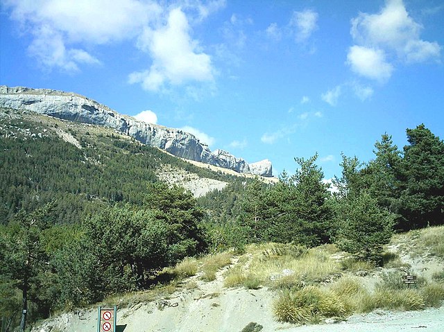
Pelleautier is a beautiful commune located in the Hautes-Alpes region of southeastern France. Nestled near the foot of the Écrins mountains and close to the city of Gap, it offers a range of hiking opportunities that cater to various skill levels.
Hiking Trails
-
Local Trails: Pelleautier provides access to several local trails that wind through forests, meadows, and provide stunning panoramic views of the surrounding mountains. These trails are often less crowded, allowing for a more peaceful hiking experience.
-
Sentier de l'Ermitage: This is a popular trail that leads to a small hermitage, offering beautiful views of the valley and the mountains beyond. It is a moderate hike and is suitable for families.
-
Ecrins National Park: While not directly in Pelleautier, the nearby Ecrins National Park is an incredible place for hiking, featuring a variety of trails ranging from easy walks to challenging climbs. The park is known for its stunning landscapes, alpine meadows, and diverse wildlife.
Tips for Hiking in Pelleautier
-
Gear Up: Ensure you have proper hiking boots, weather-appropriate clothing, and a good backpack. Trekking poles can be useful on steeper trails.
-
Stay Hydrated and Nourished: Carry enough water and snacks to keep your energy up during hikes. It's important to stay hydrated, especially in the warmer months.
-
Check Weather Conditions: The weather can change quickly in the mountains. Always check forecasts and be prepared for sudden changes.
-
Navigation Tools: While many trails may be well-marked, having a map or a GPS device can help ensure you stay on the right path.
-
Wildlife Awareness: Keep an eye out for the local wildlife and respect their habitat. Avoid feeding animals and maintain a safe distance.
-
Leave No Trace: Practice responsible hiking by cleaning up after yourself, staying on designated trails, and minimizing your impact on the environment.
Best Time to Hike
The best time for hiking in Pelleautier is during the spring through fall months (April to October), when the weather is mild, and trails are more accessible. Summer can get quite busy, so if you prefer solitude, consider hiking in the shoulder seasons.
Local Attractions
After a day of hiking, you may want to explore the local village, enjoy regional cuisine, or visit nearby attractions such as the town of Gap, where you can find shops, restaurants, and cultural sites.
Whether you're looking for a peaceful day hike or an adventurous trek, Pelleautier and its surroundings offer a rich experience for outdoor enthusiasts. Happy hiking!
- Country:

- Postal Code: 05000
- Coordinates: 44° 31' 1" N, 6° 1' 0" E


- GPS tracks (wikiloc): [Link]
- Area: 12.81 sq km
- Population: 684
- Wikipedia en: wiki(en)
- Wikipedia: wiki(fr)
- Wikidata storage: Wikidata: Q1087604
- Wikipedia Commons Category: [Link]
- Freebase ID: [/m/03mfpw1]
- Freebase ID: [/m/03mfpw1]
- GeoNames ID: Alt: [6425607]
- GeoNames ID: Alt: [6425607]
- SIREN number: [210501003]
- SIREN number: [210501003]
- PACTOLS thesaurus ID: [pcrtLVfkNRFiPM]
- PACTOLS thesaurus ID: [pcrtLVfkNRFiPM]
- WOEID: [615941]
- WOEID: [615941]
- INSEE municipality code: 05100
- INSEE municipality code: 05100
Shares border with regions:
Châteauneuf-d'Oze
- commune in Hautes-Alpes, France
Hiking in Châteauneuf-d'Oze
Châteauneuf-d'Oze is a charming village located in the Hautes-Alpes region of southeastern France. Nestled in the picturesque Oisans area, it's surrounded by stunning mountain scenery, making it an attractive destination for hikers. Here are some highlights and tips for hiking in and around Châteauneuf-d'Oze:...
- Country:
- Postal Code: 05400
- Coordinates: 44° 30' 42" N, 5° 51' 53" E
- GPS tracks (wikiloc): [Link]
- Area: 26.23 sq km
- Population: 27
Neffes
- commune in Hautes-Alpes, France
Hiking in Neffes
Neffes is not a widely recognized hiking destination, so it’s possible that you’re referring to a specific area or trail that's less known. If you’re referring to a particular region, here are a few general tips and considerations for hiking in lesser-known areas:...
- Country:
- Postal Code: 05000
- Coordinates: 44° 30' 16" N, 6° 1' 20" E
- GPS tracks (wikiloc): [Link]
- Area: 8.36 sq km
- Population: 744

Manteyer
- commune in Hautes-Alpes, France
Hiking in Manteyer
Manteyer is a charming village located in the Hautes-Alpes region of France, offering a variety of hiking opportunities that cater to different skill levels and interests. The area is characterized by its stunning natural landscapes, including rolling hills, forests, and panoramic views of the surrounding Alpine terrain....
- Country:
- Postal Code: 05400
- Coordinates: 44° 32' 16" N, 5° 57' 50" E
- GPS tracks (wikiloc): [Link]
- Area: 25.63 sq km
- Population: 424
- Web site: [Link]

Sigoyer
- commune in Hautes-Alpes, France
Hiking in Sigoyer
Sigoyer is a charming village located in the Hautes-Alpes region of southeastern France. It offers a picturesque setting and is an excellent base for outdoor enthusiasts looking to explore the scenic beauty of the surrounding area. Here are some highlights for hiking in and around Sigoyer:...
- Country:
- Postal Code: 05130
- Coordinates: 44° 28' 40" N, 5° 58' 33" E
- GPS tracks (wikiloc): [Link]
- Area: 24.38 sq km
- Population: 664
- Web site: [Link]

Gap
- commune in Hautes-Alpes, France
Hiking in Gap
Gap, located in the Hautes-Alpes region of southeastern France, is a wonderful destination for hiking enthusiasts. Surrounded by majestic mountains and alpine landscapes, it offers a variety of trails that cater to all levels of hikers, from beginners to experienced trekkers....
- Country:
- Postal Code: 05000
- Coordinates: 44° 33' 31" N, 6° 4' 40" E
- GPS tracks (wikiloc): [Link]
- Area: 110.43 sq km
- Population: 40776
- Web site: [Link]

La Freissinouse
- commune in Hautes-Alpes, France
Hiking in La Freissinouse
La Freissinouse is a charming village located in the Hautes-Alpes department of southeastern France, nestled in the heart of the French Alps. The region is known for its stunning natural beauty, making it a great destination for hiking enthusiasts....
- Country:
- Postal Code: 05000
- Coordinates: 44° 32' 5" N, 6° 0' 35" E
- GPS tracks (wikiloc): [Link]
- Area: 8.32 sq km
- Population: 786