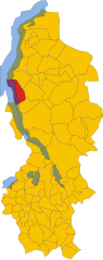
Perledo (Perledo)
.svg)
- Italian comune
 Hiking in Perledo
Perledo is a charming village located in the province of Lecco, in the Lombardy region of Italy, perched above the eastern shore of Lake Como. It offers stunning views of the lake and the surrounding mountains, making it an attractive destination for hikers. Here are some key points to consider when hiking in and around Perledo:
Popular Hiking Trails
-
Sentiero del Viandante: This historical path stretches along the eastern shore of Lake Como and passes through villages, including Perledo. It offers beautiful views of the lake, olive groves, and terraced vineyards. The trail is well-marked, and segments can be adjusted to suit your fitness level.
-
Cerro di Riva (Monte di Riva): This hike takes you to the summit of Cerro di Riva, providing panoramic views of Lake Como and the surrounding mountains. The ascent is moderate and quite rewarding, particularly at the top.
-
Trail to Vezio Castle: A short hike from Perledo leads to Castello di Vezio, an ancient castle with stunning views over the lake. The castle is accessible via a well-marked trail and offers a glimpse into local history and your opportunity to enjoy scenic vistas.
-
Strada Regia: An ancient royal road that runs along the hillside offering beautiful views of Lake Como. The trail connects various villages and makes for a lovely day hike among nature.
Tips for Hiking in Perledo
-
Difficulty Levels: Make sure to choose trails that match your skill level. Some paths may be steep and rocky, while others are more relaxed and family-friendly.
-
Weather Considerations: The weather can change rapidly in the mountains. Always check the forecast, dress in layers, and bring rain gear just in case.
-
Hydration and Snacks: Carry enough water and snacks, especially on longer hikes, as facilities might be limited along some paths.
-
Local Maps and Guides: Though trails are generally well-marked, having a local map or guide can enhance your experience and help you navigate.
-
Wildlife and Flora: Keep an eye out for the local flora and fauna, including wildflowers, birds, and possibly even deer or foxes along the trails.
Conclusion
Hiking in Perledo can be a delightful experience, combining breathtaking landscapes, rich history, and the charm of Italian culture. Whether you're an experienced hiker or a beginner, there's something for everyone in this beautiful part of Italy. Enjoy your trekking adventures, and don't forget your camera to capture the stunning views!
- Country:

- Postal Code: 23828
- Local Dialing Code: 0341
- Licence Plate Code: LC
- Coordinates: 46° 1' 0" N, 9° 18' 0" E


- GPS tracks (wikiloc): [Link]
- AboveSeaLevel: 395 м m
- Area: 13.68 sq km
- Population: 916
- Web site: http://www.comune.perledo.lc.it
- Wikipedia en: wiki(en)
- Wikipedia: wiki(it)
- Wikidata storage: Wikidata: Q42529
- Wikipedia Commons Category: [Link]
- Freebase ID: [/m/0gr4dp]
- GeoNames ID: Alt: [6543339]
- OSM relation ID: [46722]
- MusicBrainz area ID: [de989384-755a-4ba1-bae5-8313bfbf6867]
- ISTAT ID: 097067
- Italian cadastre code: G456
- LombardiaBeniCulturali toponym ID: 5000267
Shares border with regions:
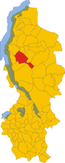
Parlasco
- Italian comune
Hiking in Parlasco
Parlasco is a charming village located in the Lombardy region of Italy, nestled in the upper Valassina valley and surrounded by the scenic Grigna and Resegone mountain ranges. It offers a range of hiking opportunities for outdoor enthusiasts, making it a great destination for both casual walkers and experienced hikers....
- Country:
- Postal Code: 23837
- Local Dialing Code: 0341
- Licence Plate Code: LC
- Coordinates: 46° 1' 0" N, 9° 21' 0" E
- GPS tracks (wikiloc): [Link]
- AboveSeaLevel: 679 м m
- Area: 3 sq km
- Population: 140
- Web site: [Link]

Varenna
- Italian comune
Hiking in Varenna
Varenna, a picturesque village on the eastern shore of Lake Como in Italy, is an excellent destination for hiking enthusiasts. The area offers a beautiful mix of natural beauty, cultural heritage, and well-maintained trails....
- Country:
- Postal Code: 23829
- Local Dialing Code: 0341
- Licence Plate Code: LC
- Coordinates: 46° 0' 39" N, 9° 17' 2" E
- GPS tracks (wikiloc): [Link]
- AboveSeaLevel: 220 м m
- Area: 12.57 sq km
- Population: 739
- Web site: [Link]


Bellano
- Italian comune
Hiking in Bellano
Bellano is a charming village located on the eastern shore of Lake Como in Italy, known for its beautiful landscapes and hiking opportunities. Here are some highlights about hiking in Bellano:...
- Country:
- Postal Code: 23822
- Local Dialing Code: 0341
- Licence Plate Code: LC
- Coordinates: 46° 2' 36" N, 9° 18' 22" E
- GPS tracks (wikiloc): [Link]
- AboveSeaLevel: 202 м m
- Area: 10.23 sq km
- Population: 3203
- Web site: [Link]

Esino Lario
- ancient village of Lake Como
Hiking in Esino Lario
Esino Lario, located in the Lombardy region of Italy, is a beautiful destination for hikers, offering stunning views of the surrounding mountains and Lake Como. The village is situated at an altitude of about 1,000 meters (3,300 feet), making it a fantastic starting point for various hiking trails. Here’s an overview of what to expect when hiking in Esino Lario:...
- Country:
- Postal Code: 23825
- Local Dialing Code: 0341
- Coordinates: 45° 59' 38" N, 9° 19' 59" E
- GPS tracks (wikiloc): [Link]
- AboveSeaLevel: 910 м m
- Area: 18.05 sq km
- Population: 747
- Web site: [Link]


Menaggio
- Italian comune
Hiking in Menaggio
Menaggio, located on the western shore of Lake Como in Italy, is a fantastic destination for hiking enthusiasts. The area offers stunning views, diverse trails, and a beautiful natural landscape that attracts visitors year-round. Here are some things to know about hiking in Menaggio:...
- Country:
- Postal Code: 22017
- Local Dialing Code: 0344
- Licence Plate Code: CO
- Coordinates: 46° 1' 0" N, 9° 14' 0" E
- GPS tracks (wikiloc): [Link]
- AboveSeaLevel: 202 м m
- Area: 11.77 sq km
- Population: 3107
- Web site: [Link]


San Siro
- Italian comune
Hiking in San Siro
San Siro, located in the province of Como in Northern Italy, is a beautiful area known for its stunning natural landscapes and picturesque hiking trails. It's situated along the western shore of Lake Como, and the combination of mountains and the lake provides hikers with breathtaking views and diverse terrain. Here are some highlights for hiking in San Siro:...
- Country:
- Postal Code: 22010
- Local Dialing Code: 0344
- Licence Plate Code: CO
- Coordinates: 46° 3' 53" N, 9° 16' 0" E
- GPS tracks (wikiloc): [Link]
- AboveSeaLevel: 220 м m
- Area: 18.79 sq km
- Population: 1744
- Web site: [Link]