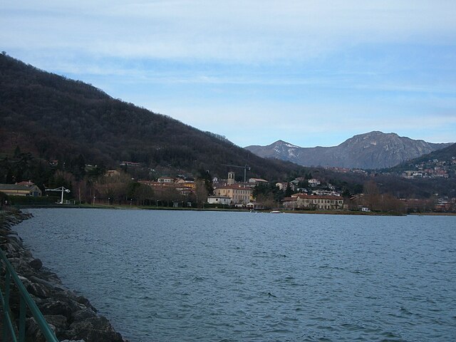
Pescate (Pescate)
.svg)
- Italian comune
 Hiking in Pescate
Pescate, a small town located in the Lombardy region of Italy, offers a stunning backdrop for hiking enthusiasts due to its proximity to beautiful natural landscapes, including Lake Lecco and the surrounding mountains. Here are some highlights for those interested in hiking in the Pescate area:
Trails and Routes
-
Sentiero del Fiume Adda: This trail follows the Adda River and offers scenic views of the water, as well as the surrounding flora and fauna. It's suitable for various skill levels and is ideal for a leisurely hike.
-
Mountain Trails: The nearby mountains, including those in the Grigna Regional Park, provide more challenging hikes. There are multiple trails ranging from moderate to difficult, perfect for hikers looking for a bit of adventure.
-
Lake Views: Many trails around Pescate offer stunning views of Lake Como and the surrounding peaks. The panoramas can be breathtaking, especially at sunrise or sunset.
Season Considerations
- Best Time to Hike: The best seasons for hiking around Pescate are spring (April to June) and fall (September to October). During these months, the weather is usually mild, and the natural scenery is at its most vibrant.
Hiking Preparation
- Gear: Make sure to wear proper hiking boots and clothing suitable for the conditions. A good backpack with water, snacks, and a first-aid kit is essential.
- Navigation: While many trails are well-marked, having a detailed map or a GPS-enabled device can be beneficial, especially for more challenging routes.
Local Amenities
- Pescate has basic amenities like cafes and restaurants where you can refuel after a hike. Always check the operating hours, especially in the off-peak season.
Wildlife and Environment
- The area around Pescate is rich in biodiversity. Keep an eye out for various bird species and native plants. Respect the environment by staying on marked paths and following the Leave No Trace principles.
Safety Considerations
- Always inform someone about your hiking plans, especially if you are hiking alone or in remote areas.
- It's advisable to check the weather forecast before heading out to ensure safe hiking conditions.
Hiking around Pescate can be a rewarding experience, offering both tranquility and adventure amid some of Italy's most stunning landscapes.
- Country:

- Postal Code: 23855
- Local Dialing Code: 0341
- Licence Plate Code: LC
- Coordinates: 45° 50' 0" N, 9° 24' 0" E


- GPS tracks (wikiloc): [Link]
- AboveSeaLevel: 214 м m
- Area: 2.1 sq km
- Population: 2231
- Web site: http://www.comune.pescate.lc.it
- Wikipedia en: wiki(en)
- Wikipedia: wiki(it)
- Wikidata storage: Wikidata: Q42550
- Wikipedia Commons Category: [Link]
- Freebase ID: [/m/0gr4fd]
- GeoNames ID: Alt: [6543340]
- OSM relation ID: [46245]
- UN/LOCODE: [ITPSE]
- ISTAT ID: 097068
- Italian cadastre code: G485
Shares border with regions:

Garlate
- Italian comune
Hiking in Garlate
Garlate is a small town located in the province of Lecco in northern Italy, situated near the shores of Lake Garlate. The area offers beautiful scenery, making it a pleasant destination for hiking enthusiasts. Here are some highlights and tips for hiking in and around Garlate:...
- Country:
- Postal Code: 23852
- Local Dialing Code: 0341
- Licence Plate Code: LC
- Coordinates: 45° 48' 0" N, 9° 24' 0" E
- GPS tracks (wikiloc): [Link]
- AboveSeaLevel: 205 м m
- Area: 3.3 sq km
- Population: 2731
- Web site: [Link]
Galbiate
- Italian comune
Hiking in Galbiate
Galbiate, located in the province of Lecco in Lombardy, Italy, is a delightful destination for hiking enthusiasts. Nestled close to Lake Como and surrounded by stunning natural landscapes, it offers various trails catering to different skill levels. Here are some key highlights of hiking in Galbiate:...
- Country:
- Postal Code: 23851
- Local Dialing Code: 0341
- Licence Plate Code: LC
- Coordinates: 45° 48' 0" N, 9° 23' 0" E
- GPS tracks (wikiloc): [Link]
- AboveSeaLevel: 371 м m
- Area: 15.64 sq km
- Population: 8545
- Web site: [Link]


Lecco
- Italian comune
Hiking in Lecco
Lecco, located in the Lombardy region of northern Italy, is a fantastic destination for hiking enthusiasts. Nestled at the southeastern tip of Lake Como, it offers stunning natural landscapes, diverse trails, and breathtaking views of the surrounding mountains, including the Grigna and Resegone ranges....
- Country:
- Postal Code: 23900
- Local Dialing Code: 0341
- Licence Plate Code: LC
- Coordinates: 45° 51' 0" N, 9° 24' 0" E
- GPS tracks (wikiloc): [Link]
- AboveSeaLevel: 214 м m
- Area: 45.14 sq km
- Population: 48177
- Web site: [Link]