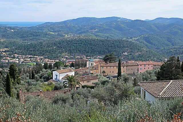
Peymeinade (Peymeinade)
- commune in Alpes-Maritimes, France
 Hiking in Peymeinade
Peymeinade, a charming village located in the Alpes-Maritimes region of France, is an excellent starting point for hiking enthusiasts. Nestled in the foothills of the picturesque Provencal countryside, it offers a variety of trails that cater to all skill levels.
Hiking Trails
-
Sentier de la Chapelle
- This is a relatively easy hike that takes you through scenic landscapes and olive groves. The trail leads to the charming Chapelle Saint-Bernard, where you can enjoy panoramic views of the surrounding area.
-
Les Gorges du Loup
- A short drive from Peymeinade, this area features stunning cliffs and the beautiful Gorges du Loup river. The hikes here can vary in difficulty but are generally well-marked, making them accessible for most hikers.
-
Montagne de la Louve
- For those looking for a more challenging trek, the Montagne de la Louve offers several paths, with the chance to reach higher altitudes and witness breathtaking views of the French Riviera.
-
Network of Trails
- There are numerous interconnected trails around Peymeinade, which allows for creating custom hikes depending on your stamina and interests. Many routes intertwine with pathways that date back to ancient times, adding a historic flavor to your hike.
Tips for Hiking in Peymeinade
- Best Time to Hike: Spring and fall are ideal due to mild temperatures. Summer can be quite hot, so it's best to start hikes early in the day.
- Gear: Wear comfortable hiking boots, bring plenty of water, a map or GPS device, and sun protection (hat, sunscreen).
- Local Wildlife: Keep an eye out for local flora and fauna. The area is rich in biodiversity, and you may spot various bird species and wildflowers.
- Respect Nature: Follow Leave No Trace principles and stay on marked trails to preserve the natural beauty of the region.
Local Amenities
Peymeinade offers cafes and restaurants where you can enjoy local cuisine after your hike. Additionally, there are accommodation options ranging from quaint inns to vacation rentals for those wishing to extend their stay and explore more of the surrounding region.
Conclusion
Hiking in Peymeinade provides a wonderful opportunity to immerse yourself in the stunning landscapes of the French Riviera while enjoying the peaceful countryside. Whether you're a casual walker or an experienced hiker, the variety of trails here will surely satisfy your adventurous spirit.
- Country:

- Postal Code: 06530
- Coordinates: 43° 38' 32" N, 6° 52' 33" E


- GPS tracks (wikiloc): [Link]
- Area: 9.76 sq km
- Population: 8116
- Web site: http://www.peymeinade.fr/
- Wikipedia en: wiki(en)
- Wikipedia: wiki(fr)
- Wikidata storage: Wikidata: Q643248
- Wikipedia Commons Category: [Link]
- Freebase ID: [/m/03m4zkm]
- Freebase ID: [/m/03m4zkm]
- GeoNames ID: Alt: [6446727]
- GeoNames ID: Alt: [6446727]
- SIREN number: [210600953]
- SIREN number: [210600953]
- VIAF ID: Alt: [239657251]
- VIAF ID: Alt: [239657251]
- PACTOLS thesaurus ID: [pcrtEji8zq6yBc]
- PACTOLS thesaurus ID: [pcrtEji8zq6yBc]
- Quora topic ID: [Peymeinade]
- Quora topic ID: [Peymeinade]
- INSEE municipality code: 06095
- INSEE municipality code: 06095
Shares border with regions:


Grasse
- commune in Alpes-Maritimes, France
Hiking in Grasse
Grasse, located in the Alpes-Maritimes department in the Provence-Alpes-Côte d'Azur region of France, is famous for its perfume industry and beautiful landscapes. Hiking in and around Grasse offers a range of trails, stunning views, and a chance to experience the rich natural and cultural heritage of the area....
- Country:
- Postal Code: 06520; 06130
- Coordinates: 43° 39' 29" N, 6° 55' 31" E
- GPS tracks (wikiloc): [Link]
- AboveSeaLevel: 333 м m
- Area: 44.44 sq km
- Population: 50937
- Web site: [Link]


Spéracèdes
- commune in Alpes-Maritimes, France
Hiking in Spéracèdes
Spéracèdes is a charming village located in the Alpes-Maritimes department in the Provence-Alpes-Côte d'Azur region of France. It offers a variety of hiking opportunities amidst stunning landscapes, rolling hills, and nearby natural parks. Here are some highlights and tips for hiking in and around Spéracèdes:...
- Country:
- Postal Code: 06530
- Coordinates: 43° 38' 55" N, 6° 51' 31" E
- GPS tracks (wikiloc): [Link]
- Area: 3.46 sq km
- Population: 1295


Auribeau-sur-Siagne
- commune in Alpes-Maritimes, France
Hiking in Auribeau-sur-Siagne
Auribeau-sur-Siagne is a picturesque village located in the Alpes-Maritimes region of France, near the French Riviera. It's nestled in the hills and offers a variety of hiking opportunities that showcase its natural beauty and the surrounding landscape....
- Country:
- Postal Code: 06810
- Coordinates: 43° 36' 3" N, 6° 54' 40" E
- GPS tracks (wikiloc): [Link]
- Area: 5.48 sq km
- Population: 3219
- Web site: [Link]

Cabris
- commune in Alpes-Maritimes, France
Hiking in Cabris
Cabris is a charming village located in the Alpes-Maritimes department of the Provence-Alpes-Côte d'Azur region in southeastern France. Perched on a hill, it offers stunning views of the surrounding countryside, making it a wonderful base for hiking enthusiasts. Here are some highlights of hiking in the Cabris area:...
- Country:
- Postal Code: 06530
- Coordinates: 43° 39' 22" N, 6° 52' 25" E
- GPS tracks (wikiloc): [Link]
- Area: 5.43 sq km
- Population: 1295
- Web site: [Link]

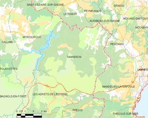
Tanneron
- commune in Var, France
Hiking in Tanneron
Tanneron is a picturesque village located in the Alpes-Maritimes department in the Provence-Alpes-Côte d'Azur region of southeastern France. Known for its stunning natural landscapes, the area offers a variety of hiking opportunities that cater to different experience levels....
- Country:
- Postal Code: 83440
- Coordinates: 43° 35' 26" N, 6° 52' 32" E
- GPS tracks (wikiloc): [Link]
- Area: 52.78 sq km
- Population: 1572

Le Tignet
- commune in Alpes-Maritimes, France
Hiking in Le Tignet
Le Tignet is a charming village located in the Alpes-Maritimes region of France, not far from the French Riviera. It's known for its beautiful landscapes, picturesque views, and proximity to the Verdon Gorge and the hills of the Provence hinterlands. Here are some key aspects of hiking in this area:...
- Country:
- Postal Code: 06530
- Coordinates: 43° 37' 45" N, 6° 50' 37" E
- GPS tracks (wikiloc): [Link]
- Area: 11.26 sq km
- Population: 3311