Peyrecave (Peyrecave)

- commune in Gers, France
- Country:

- Postal Code: 32340
- Coordinates: 43° 59' 49" N, 0° 49' 11" E


- GPS tracks (wikiloc): [Link]
- Area: 5.07 sq km
- Population: 71
- Wikipedia en: wiki(en)
- Wikipedia: wiki(fr)
- Wikidata storage: Wikidata: Q1004890
- Wikipedia Commons Category: [Link]
- Freebase ID: [/m/03nrryw]
- GeoNames ID: Alt: [6612475]
- SIREN number: [213203144]
- BnF ID: [15255900x]
- INSEE municipality code: 32314
Shares border with regions:


Lachapelle
- commune in Tarn-et-Garonne, France
- Country:
- Postal Code: 82120
- Coordinates: 43° 59' 7" N, 0° 50' 33" E
- GPS tracks (wikiloc): [Link]
- Area: 10.87 sq km
- Population: 116
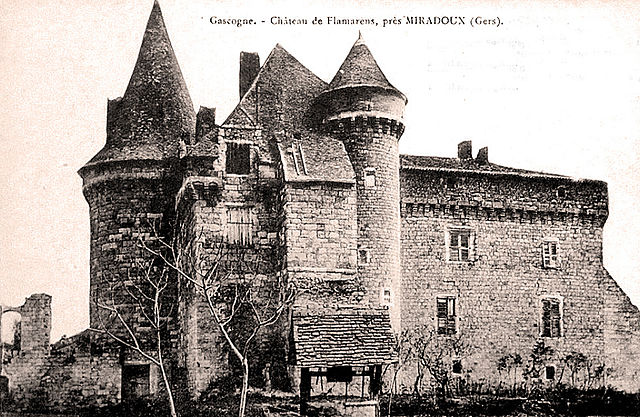
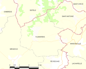
Flamarens
- commune in Gers, France
- Country:
- Postal Code: 32340
- Coordinates: 44° 1' 1" N, 0° 47' 34" E
- GPS tracks (wikiloc): [Link]
- Area: 14.36 sq km
- Population: 139


Miradoux
- commune in Gers, France
- Country:
- Postal Code: 32340
- Coordinates: 43° 59' 52" N, 0° 45' 21" E
- GPS tracks (wikiloc): [Link]
- Area: 34.58 sq km
- Population: 508


Mansonville
- commune in Tarn-et-Garonne, France
- Country:
- Postal Code: 82120
- Coordinates: 44° 0' 59" N, 0° 50' 27" E
- GPS tracks (wikiloc): [Link]
- Area: 15.45 sq km
- Population: 286