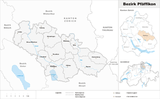
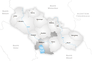
Pfäffikon District (Bezirk Pfäffikon)
- district of the canton of Zürich, Switzerland
Pfäffikon District, located in the canton of Zurich, Switzerland, offers a picturesque landscape that's ideal for hiking enthusiasts. It's characterized by rolling hills, lush forests, and scenic lakes, making it a beautiful destination for outdoor activities.
Hiking Trails
There are several well-marked hiking trails in the area suitable for different fitness levels:
-
Pfäffikersee Lake Loop: This trail encircles Lake Pfäffikon, offering stunning views of the water and surrounding landscapes. It's a relatively easy hike, making it perfect for families and beginners.
-
Zürich Oberland Trail: Parts of this long-distance trail pass through the district. It presents an excellent opportunity for more seasoned hikers looking for a challenge, with varied terrain and breathtaking views.
-
Hiking in the Forests: The district has several forest trails where you can enjoy a peaceful hike and perhaps catch a glimpse of local wildlife. The routes vary in difficulty, from easy walks to more gradual climbs.
Points of Interest
-
Pfäffikersee Nature Reserve: This area is not only great for hiking but also for birdwatching and enjoying the local flora and fauna. The nature reserve protects the lake and its surroundings, ensuring a tranquil hiking experience.
-
Historical Sites: While hiking, you might encounter historical sites, including old churches and charming villages like Rüti or Wetzikon, where you can take breaks and explore local culture.
Best Times to Hike
The best time to hike in Pfäffikon District is during the spring and fall months when the weather is mild, and the scenery is particularly vibrant. Summer can also be enjoyable, but be prepared for warmer temperatures, and always stay hydrated.
Tips for Hiking
- Gear: Wear sturdy hiking shoes and dress in layers to adapt to changing weather conditions.
- Navigation: Carry a map or use a reliable hiking app to navigate the trails, especially on less marked paths.
- Leave No Trace: Be sure to respect the natural environment by following Leave No Trace principles. Keep the area clean and avoid disturbing wildlife.
Whether you're looking for a leisurely walk by the lake or a challenging hike through the woods, Pfäffikon District has something to offer for everyone. Enjoy your adventure!
- Country:

- Capital: Pfäffikon
- Licence Plate Code: ZH
- Coordinates: 47° 24' 0" N, 8° 47' 0" E


- GPS tracks (wikiloc): [Link]
- AboveSeaLevel: 715 м m
- Area: 163.55 sq km
- Wikipedia en: wiki(en)
- Wikipedia: wiki(de)
- Wikidata storage: Wikidata: Q660395
- Freebase ID: [/m/026n289]
- GeoNames ID: Alt: [6458852]
- archINFORM location ID: [42726]
- HDS ID: [122]
Includes regions:


Illnau-Effretikon
- municipality in Switzerland
Illnau-Effretikon is a municipality located in the canton of Zurich, Switzerland. It's a lovely region that offers a variety of beautiful landscapes and hiking opportunities, making it an excellent destination for outdoor enthusiasts....
- Country:

- Postal Code: 8308; 8307
- Local Dialing Code: 052
- Licence Plate Code: ZH
- Coordinates: 47° 24' 57" N, 8° 43' 11" E


- GPS tracks (wikiloc): [Link]
- AboveSeaLevel: 516 м m
- Area: 25.28 sq km
- Population: 16928
- Web site: [Link]


Lindau
- municipality in Switzerland
Lindau, while often known as a beautiful island town in Lake Constance, is also a great starting point for various hiking adventures in the surrounding areas of Switzerland and Germany. Here are some highlights and information for hiking in and around Lindau:...
- Country:

- Postal Code: 8315
- Local Dialing Code: 052
- Licence Plate Code: ZH
- Coordinates: 47° 26' 35" N, 8° 40' 19" E


- GPS tracks (wikiloc): [Link]
- AboveSeaLevel: 519 м m
- Area: 11.96 sq km
- Population: 5621
- Web site: [Link]

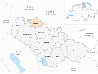
Kyburg
- former municipality of Switzerland
Hiking in Kyburg, located near Zürich, Switzerland, offers a fantastic experience for outdoor enthusiasts. The area is known for its picturesque landscapes, rich history, and well-maintained hiking trails that cater to a variety of skill levels....
- Country:

- Postal Code: 8314
- Local Dialing Code: 052
- Licence Plate Code: ZH
- Coordinates: 47° 27' 28" N, 8° 44' 42" E


- GPS tracks (wikiloc): [Link]
- AboveSeaLevel: 625 м m
- Area: 7.58 sq km
- Population: 405
- Web site: [Link]
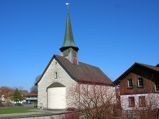

Hittnau
- municipality in Switzerland
Hittnau is a charming village located in the Zurich regon of Switzerland, and it offers a variety of hiking opportunities that cater to different skill levels. Here are some highlights of hiking in and around Hittnau:...
- Country:

- Postal Code: 8335
- Licence Plate Code: ZH
- Coordinates: 47° 22' 12" N, 8° 49' 26" E


- GPS tracks (wikiloc): [Link]
- AboveSeaLevel: 670 м m
- Area: 12.95 sq km
- Population: 3613
- Web site: [Link]


Sternenberg
- former municipality of Switzerland
Sternenberg is an attractive destination for hiking enthusiasts, located in the beautiful region of Switzerland. Here are some key points to consider if you're exploring the area:...
- Country:

- Postal Code: 8499
- Local Dialing Code: 052
- Licence Plate Code: ZH
- Coordinates: 47° 23' 0" N, 8° 55' 0" E


- GPS tracks (wikiloc): [Link]
- AboveSeaLevel: 869 м m
- Area: 8.75 sq km
- Web site: [Link]


Wila
- municipality in Switzerland
Wila is a charming village located in the Zurich Oberland region of Switzerland, making it a great starting point for various hiking adventures. The area is characterized by picturesque landscapes, lush forests, rolling hills, and breathtaking views of the surrounding Alps....
- Country:

- Postal Code: 8492
- Local Dialing Code: 052
- Licence Plate Code: ZH
- Coordinates: 47° 24' 33" N, 8° 51' 39" E


- GPS tracks (wikiloc): [Link]
- AboveSeaLevel: 579 м m
- Area: 9.21 sq km
- Population: 1975
- Web site: [Link]


Bauma
- municipality in Switzerland
Bauma, located in the Zurich canton of Switzerland, is a charming town nestled in a picturesque landscape. The region offers a variety of hiking opportunities that cater to different skill levels and preferences....
- Country:

- Postal Code: 8494
- Local Dialing Code: 052
- Licence Plate Code: ZH
- Coordinates: 47° 22' 24" N, 8° 53' 2" E


- GPS tracks (wikiloc): [Link]
- AboveSeaLevel: 755 м m
- Area: 29.53 sq km
- Population: 4925
- Web site: [Link]


Wildberg
- municipality in Switzerland
Wildberg, Switzerland, offers a beautiful hiking experience with a mix of scenic views, lush landscapes, and well-maintained trails. The area is characterized by its picturesque surroundings, including rolling hills, forests, and stunning alpine scenery....
- Country:

- Postal Code: 8489
- Local Dialing Code: 052
- Licence Plate Code: ZH
- Coordinates: 47° 25' 43" N, 8° 48' 59" E


- GPS tracks (wikiloc): [Link]
- AboveSeaLevel: 650 м m
- Area: 10.56 sq km
- Population: 994
- Web site: [Link]
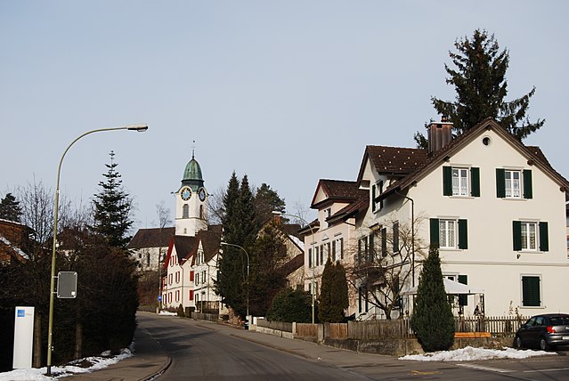

Russikon
- municipality in Switzerland
Russikon is a charming municipality located in the Canton of Zurich, Switzerland, and offers beautiful hiking opportunities in the surrounding areas. Here are some key points to consider if you're planning to hike in Russikon:...
- Country:

- Postal Code: 8332
- Licence Plate Code: ZH
- Coordinates: 47° 24' 4" N, 8° 47' 16" E


- GPS tracks (wikiloc): [Link]
- AboveSeaLevel: 647 м m
- Area: 14.23 sq km
- Population: 4355
- Web site: [Link]

Pfäffikon
- municipality in Switzerland
Pfäffikon, located in the Zürich region of Switzerland, is a fantastic spot for hiking enthusiasts. It offers a beautiful mix of lake views, rolling hills, and scenic countryside. Here are some key highlights and tips for hiking in the area:...
- Country:

- Postal Code: 8330
- Local Dialing Code: 044
- Licence Plate Code: ZH
- Coordinates: 47° 22' 0" N, 8° 46' 56" E


- GPS tracks (wikiloc): [Link]
- AboveSeaLevel: 578 м m
- Area: 19.55 sq km
- Population: 11817
- Web site: [Link]


Fehraltorf
- municipality in Switzerland
Fehraltorf, located in the Canton of Zurich in Switzerland, offers a beautiful setting for hiking enthusiasts. The area is characterized by rolling hills, scenic landscapes, and a mix of agricultural land and natural beauty, making it ideal for both casual walkers and more dedicated hikers. Here are some highlights to consider when hiking in Fehraltorf:...
- Country:

- Postal Code: 8320
- Local Dialing Code: 043
- Licence Plate Code: ZH
- Coordinates: 47° 23' 14" N, 8° 45' 0" E


- GPS tracks (wikiloc): [Link]
- AboveSeaLevel: 530 м m
- Area: 9.48 sq km
- Population: 6378
- Web site: [Link]


Weisslingen
- municipality in Switzerland
Weisslingen is a picturesque village located in the Zurich region of Switzerland, known for its beautiful landscapes and access to outdoor activities, including hiking. Here are some insights and tips for hiking in Weisslingen:...
- Country:

- Postal Code: 8484
- Local Dialing Code: 052
- Licence Plate Code: ZH
- Coordinates: 47° 25' 49" N, 8° 46' 24" E


- GPS tracks (wikiloc): [Link]
- AboveSeaLevel: 668 м m
- Area: 12.81 sq km
- Population: 3301
- Web site: [Link]
Shares border with regions:


Uster District
- district of the canton of Zürich, Switzerland
Uster District, located in the canton of Zurich in Switzerland, offers a variety of hiking opportunities that cater to different skill levels and preferences. The lush landscapes, scenic lakes, and picturesque hills make it an appealing destination for nature lovers and outdoor enthusiasts. Here are some highlights and suggestions for hiking in Uster District:...
- Country:

- Capital: Uster
- Licence Plate Code: ZH
- Coordinates: 47° 21' 0" N, 8° 41' 0" E


- GPS tracks (wikiloc): [Link]
- AboveSeaLevel: 433 м m
- Area: 112.35 sq km

Winterthur District
- district of the canton of Zürich, Switzerland
Hiking in the Winterthur District, located in the canton of Zurich, Switzerland, offers a wonderful blend of natural beauty, cultural heritage, and well-maintained trails. Here are some key aspects to consider for hiking in this area:...
- Country:

- Capital: Winterthur
- Licence Plate Code: ZH
- Coordinates: 47° 30' 0" N, 8° 46' 0" E


- GPS tracks (wikiloc): [Link]
- AboveSeaLevel: 460 м m
- Area: 251.30 sq km

Hinwil District
- district of the canton of Zürich, Switzerland
Hinwil District, located in the canton of Zurich in Switzerland, offers a variety of hiking opportunities that cater to all levels of experience. The beautiful landscapes, lush forests, and scenic views make it an attractive destination for outdoor enthusiasts....
- Country:

- Capital: Hinwil
- Licence Plate Code: ZH
- Coordinates: 47° 18' 0" N, 8° 51' 0" E


- GPS tracks (wikiloc): [Link]
- AboveSeaLevel: 558 м m


Bülach District
- district of the canton of Zürich, Switzerland
Bülach District, located in the Canton of Zurich in Switzerland, offers a variety of hiking opportunities that cater to different skill levels and preferences. The region is characterized by beautiful landscapes, cultivated fields, lush forests, and historic towns....
- Country:

- Capital: Bülach
- Licence Plate Code: ZH
- Coordinates: 47° 40' 0" N, 8° 34' 0" E


- GPS tracks (wikiloc): [Link]
- AboveSeaLevel: 564 м m
- Area: 185.19 sq km
- Population: 117000
