
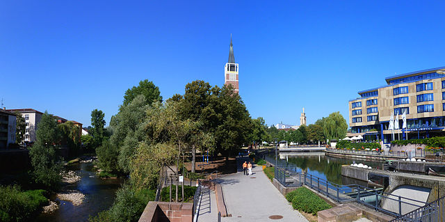
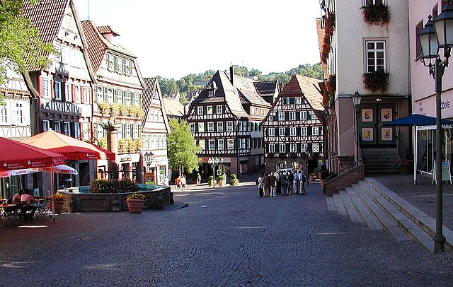
Pforzheim (Pforzheim)

.svg)
- German city
 Hiking in Pforzheim
Pforzheim, located in the northern part of the Black Forest in Germany, offers a variety of hiking opportunities that cater to different skill levels. The region is characterized by its lush forests, picturesque landscapes, and scenic trails.
Popular Hiking Areas:
-
Black Forest Trails:
- The city serves as a gateway to many trails in the Black Forest. The trails vary from easy walks to challenging hikes, making it an excellent spot for both beginners and experienced hikers.
-
Enz River Trail:
- This tranquil path follows the Enz River and provides a peaceful hiking experience. It's relatively flat and is suitable for families, offering beautiful views along the riverbanks.
-
Nagoldtal Route:
- A scenic trail that follows the Nagold River, featuring charming villages and natural landscapes. This route is ideal for day hikes, often with picnic spots along the way.
-
Hohenwart Trail:
- For those seeking a bit more of a challenge, the Hohenwart Trail offers steeper inclines and beautiful viewpoints overlooking the surrounding countryside.
Tips for Hiking in Pforzheim:
-
Trail Markings: Many trails are well-marked with signs and symbols. It's still a good idea to take a map or a GPS device, especially for longer routes.
-
Seasonal Considerations: The best time to hike in Pforzheim is from late spring to early autumn when the weather is generally mild and pleasant. Always check the weather forecast before heading out.
-
Equipment: Wear appropriate hiking footwear and bring plenty of water, snacks, and a first-aid kit. Consider trekking poles for steeper trails.
-
Local Guides: If you're unfamiliar with the area, consider hiring a local guide or joining a hiking group. They can provide insights into the flora, fauna, and history of the trails.
-
Respect Nature: Follow the Leave No Trace principles by sticking to marked paths, packing out what you pack in, and respecting wildlife.
Additional Activities:
Aside from hiking, Pforzheim is known for its jewelry and watchmaking history, so consider visiting local museums or participating in workshops. The city also has parks and botanical gardens that are worth exploring.
Whether you're hiking solo, with friends, or family, Pforzheim offers a beautiful setting to enjoy the great outdoors.
- Country:

- Postal Code: 75172–75181
- Local Dialing Code: 07231; 07234
- Licence Plate Code: PF
- Coordinates: 48° 54' 0" N, 8° 43' 0" E


- GPS tracks (wikiloc): [Link]
- AboveSeaLevel: 273 м m
- Area: 98.07 sq km
- Population: 123493
- Web site: https://www.pforzheim.de/
- Wikipedia en: wiki(en)
- Wikipedia: wiki(de)
- Wikidata storage: Wikidata: Q3046
- Wikipedia Commons Gallery: [Link]
- Wikipedia Commons Category: [Link]
- Wikipedia Commons Maps Category: [Link]
- Freebase ID: [/m/02nzyr]
- GeoNames ID: Alt: [2853969]
- BnF ID: [11880894q]
- VIAF ID: Alt: [133069115]
- OSM relation ID: [62471]
- GND ID: Alt: [4045637-7]
- archINFORM location ID: [180]
- Library of Congress authority ID: Alt: [n50057390]
- MusicBrainz area ID: [f0887372-38dd-42cd-8b01-bb5a7f206a0c]
- WOEID: [684946]
- Quora topic ID: [Pforzheim]
- SUDOC authorities ID: [026590638]
- Encyclopædia Britannica Online ID: [place/Pforzheim]
- EMLO location ID: [8d1d14cd-7a95-482d-9aa6-73e19dabe040]
- Facebook Places ID: [103782216327335]
- Great Russian Encyclopedia Online ID: [3485799]
- Digital Atlas of the Roman Empire ID: [2003]
- DMOZ ID: Alt: [Regional/Europe/Germany/States/Baden-Württemberg/Localities/Pforzheim/]
- National Library of Israel ID: [000971729]
- NUTS code: [DE129]
- Nomisma ID: [pforzheim]
- BabelNet ID: [03349163n]
- Global Anabaptist Mennonite Encyclopedia Online ID: [Pforzheim (Baden-Württemberg, Germany)]
- German municipality key: 08231000
- German district key: 08231
Includes regions:
Büchenbronn
- quarter of Pforzheim, Baden-Württemberg, Germany
Hiking in Büchenbronn
Büchenbronn is a picturesque district in the city of Pforzheim, located in the northern Black Forest region of Germany. It offers a beautiful natural landscape ideal for hiking enthusiasts. Here are some highlights and tips for hiking in the Büchenbronn area:...
- Country:
- Postal Code: 75180
- Local Dialing Code: 07231
- Coordinates: 48° 51' 24" N, 8° 39' 39" E
- GPS tracks (wikiloc): [Link]
- AboveSeaLevel: 453 м m
- Area: 11.14 sq km
- Web site: [Link]
Dillweißenstein
- quarter of Pforzheim, Baden-Württemberg, Germany
Hiking in Dillweißenstein
Dillweißenstein is a picturesque suburb of the city of Chemnitz in Germany, nestled in the foothills of the Ore Mountains. It offers a wonderful array of hiking opportunities for outdoor enthusiasts. Here are some things you should know if you're planning a hike in the area:...
- Country:
- Coordinates: 48° 52' 9" N, 8° 41' 4" E
- GPS tracks (wikiloc): [Link]
Würm
- quarter of Pforzheim, Baden-Württemberg, Germany
Hiking in Würm
Hiking in Würm, a district in Pforzheim, Germany, offers beautiful landscapes and a variety of trails for outdoor enthusiasts. The area is located in the northern Black Forest region, known for its scenic views, wooded paths, and charming villages....
- Country:
- Postal Code: 75181
- Local Dialing Code: 07231
- Coordinates: 48° 51' 25" N, 8° 44' 8" E
- GPS tracks (wikiloc): [Link]
- Area: 8.22 sq km
- Population: 2864
- Web site: [Link]
Eutingen an der Enz
- quarter of Pforzheim, Baden-Württemberg, Germany
Hiking in Eutingen an der Enz
Eutingen an der Enz is a charming locality in Germany, located in the state of Baden-Württemberg. It is situated near the Enz River, which provides a picturesque backdrop for outdoor activities such as hiking. The surrounding area offers a variety of trails suitable for different skill levels, encompassing forests, valleys, and scenic views of the countryside....
- Country:
- Postal Code: 75177
- Local Dialing Code: 07231
- Coordinates: 48° 54' 39" N, 8° 44' 45" E
- GPS tracks (wikiloc): [Link]
- AboveSeaLevel: 260 м m
- Web site: [Link]
Hohenwart
- quarter of Pforzheim, Baden-Württemberg, Germany
Hiking in Hohenwart
Hohenwart, located near Pforzheim in the Baden-Württemberg region of Germany, is surrounded by picturesque countryside and offers a variety of hiking opportunities. This area is characterized by beautiful landscapes, rolling hills, and well-maintained trails that can cater to both novice and experienced hikers....
- Country:
- Local Dialing Code: 07234
- Coordinates: 48° 49' 57" N, 8° 43' 51" E
- GPS tracks (wikiloc): [Link]
- AboveSeaLevel: 512 м m
- Area: 4.92 sq km
Shares border with regions:

Enz
- district of Baden-Württemberg, Germany
Hiking in Enz
Enzkreis, located in Baden-Württemberg, Germany, is a wonderful area for hiking enthusiasts, offering a mix of picturesque landscapes, historic towns, and diverse trail options. Here’s an overview of some aspects to consider when hiking in this region:...
- Country:
- Capital: Pforzheim
- Licence Plate Code: PF
- Coordinates: 48° 54' 0" N, 8° 45' 0" E
- GPS tracks (wikiloc): [Link]
- AboveSeaLevel: 298 м m
- Area: 573.69 sq km
- Web site: [Link]

Calw District
- district of Baden-Württemberg, Germany
Hiking in Calw District
Calw district, located in the state of Baden-Württemberg, Germany, offers a rich variety of hiking opportunities amidst beautiful natural landscapes. The area is characterized by rolling hills, dense forests, and charming villages, making it a delightful destination for both casual walkers and serious hikers....
- Country:
- Capital: Calw
- Licence Plate Code: CW
- Coordinates: 48° 42' 0" N, 8° 44' 24" E
- GPS tracks (wikiloc): [Link]
- AboveSeaLevel: 648 м m
- Area: 797.54 sq km
- Population: 150709
- Web site: [Link]