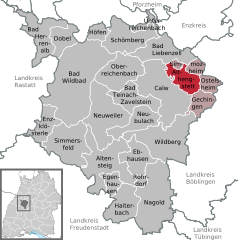
Calw District (Landkreis Calw)

- district of Baden-Württemberg, Germany
 Hiking in Calw District
Calw district, located in the state of Baden-Württemberg, Germany, offers a rich variety of hiking opportunities amidst beautiful natural landscapes. The area is characterized by rolling hills, dense forests, and charming villages, making it a delightful destination for both casual walkers and serious hikers.
Key Highlights for Hiking in Calw:
-
Scenic Trails: The district is home to numerous well-marked hiking trails. One of the most notable is the Wanderweg der Sinne (Path of the Senses), which combines nature and sensory experiences. There's also the Herkulesweg and various local routes that take you through picturesque landscapes, offering stunning views of the surrounding countryside.
-
Black Forest Region: Calw district is part of the larger Black Forest region, famous for its dense forest cover and diverse wildlife. Hiking in this area allows adventurers to immerse themselves in lush pine forests, catch glimpses of deer, and enjoy the serene beauty of the region.
-
Historic Sites: Many trails lead to historic sites such as the charming town of Calw itself, where you can explore half-timbered houses and the birthplace of writer Hermann Hesse. Along the hiking routes, you'll discover ancient castles and ruins that add a cultural element to your hikes.
-
Access to Nature Parks: The proximity to natural attractions, such as the Nagoldtalsperre (Nagold Reservoir), provides opportunities for hiking combined with water activities or picnics by the lake, enriching the outdoor experience.
-
Difficulty Levels: Trails around Calw cater to all skill levels, from easy walks suitable for families to more challenging hikes that involve steeper terrain. Ensure you select a trail that matches your fitness and experience level.
-
Seasonal Beauty: Each season in Calw offers a different hiking experience, from vibrant wildflowers in spring to colorful autumn foliage. Winter hikes can also provide a magical atmosphere, especially if there’s snowfall.
-
Local Amenities: Many trails are accessible from local villages, where you can find amenities like restaurants and cafes to refresh after your hike.
Hiking Tips:
- Preparation: Make sure to wear appropriate footwear, carry enough water, and have a map or a navigation device to help you stay on track.
- Respect Nature: Stay on marked paths to protect the local flora and fauna, and always follow Leave No Trace principles.
- Weather Check: Keep an eye on the weather forecast before heading out, as conditions can change quickly, especially in wooded areas.
Overall, hiking in Calw district can be an enriching experience, combining physical activity with nature and cultural explorations. Whether you choose a short stroll or a longer trek, you’re likely to enjoy the tranquil beauty of this charming region.
- Country:

- Capital: Calw
- Licence Plate Code: CW
- Coordinates: 48° 42' 0" N, 8° 44' 24" E


- GPS tracks (wikiloc): [Link]
- AboveSeaLevel: 648 м m
- Area: 797.54 sq km
- Population: 150709
- Web site: http://www.landkreis-calw.de/
- Wikipedia en: wiki(en)
- Wikipedia: wiki(de)
- Wikidata storage: Wikidata: Q8186
- Wikipedia Commons Category: [Link]
- Wikipedia Commons Maps Category: [Link]
- Freebase ID: [/m/01hv49]
- GeoNames ID: Alt: [2940384]
- VIAF ID: Alt: [312835859]
- OSM relation ID: [62601]
- GND ID: Alt: [4009342-6]
- archINFORM location ID: [4573]
- Library of Congress authority ID: Alt: [n89668228]
- Quora topic ID: [Calw]
- TGN ID: [7206589]
- ISNI: Alt: [0000 0004 0582 1844]
- NUTS code: [DE12A]
- Ringgold ID: [40726]
- German district key: 08235
Includes regions:

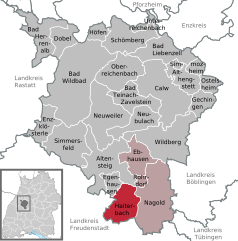
Haiterbach
- town in Baden-Württemberg, Germany
Hiking in Haiterbach
Haiterbach is a small town located in the Baden-Württemberg region of Germany, surrounded by picturesque landscapes, making it an ideal location for hiking enthusiasts. The surrounding area features a variety of trails that cater to different skill levels, from easy walks to more challenging hikes....
- Country:
- Postal Code: 72221
- Local Dialing Code: 07456
- Licence Plate Code: CW
- Coordinates: 48° 31' 28" N, 8° 39' 1" E
- GPS tracks (wikiloc): [Link]
- AboveSeaLevel: 506 м m
- Area: 28.92 sq km
- Population: 5749
- Web site: [Link]


Nagold
- city in Baden-Württemberg, Germany
Hiking in Nagold
Nagold, located in the heart of the scenic Black Forest region of Germany, offers a variety of hiking opportunities for outdoor enthusiasts. The area is known for its beautiful landscapes, lush forests, and charming villages, making it an ideal destination for both casual walkers and serious hikers....
- Country:
- Postal Code: 72202
- Local Dialing Code: 07459; 07452
- Licence Plate Code: CW
- Coordinates: 48° 33' 7" N, 8° 43' 32" E
- GPS tracks (wikiloc): [Link]
- AboveSeaLevel: 411 м m
- Area: 63.09 sq km
- Population: 21470
- Web site: [Link]

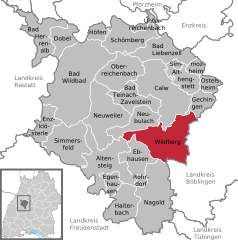
Wildberg
- town in Baden-Württemberg, Germany
Hiking in Wildberg
Wildberg, located in Baden-Württemberg, Germany, is a picturesque town that offers several wonderful hiking opportunities in the surrounding areas. The region is characterized by its beautiful landscapes, dense forests, rolling hills, and scenic views, making it an ideal destination for both novice and experienced hikers....
- Country:
- Postal Code: 72218
- Local Dialing Code: 07054
- Licence Plate Code: CW
- Coordinates: 48° 37' 26" N, 8° 44' 50" E
- GPS tracks (wikiloc): [Link]
- AboveSeaLevel: 395 м m
- Area: 56.68 sq km
- Population: 10012
- Web site: [Link]

Gechingen
- municipality in Baden-Württemberg, Germany
Hiking in Gechingen
Gechingen, a quaint village located in the district of Böblingen in Germany, offers beautiful hiking opportunities amid scenic landscapes. The area is characterized by rolling hills, lush forests, and charming rural settings. Here are some highlights for hiking in and around Gechingen:...
- Country:
- Postal Code: 75391
- Local Dialing Code: 07056
- Licence Plate Code: CW
- Coordinates: 48° 41' 44" N, 8° 49' 46" E
- GPS tracks (wikiloc): [Link]
- AboveSeaLevel: 493 м m
- Area: 14.68 sq km
- Population: 3614
- Web site: [Link]
Althengstett
- municipality in Baden-Württemberg, Germany
Hiking in Althengstett
Althengstett, a small municipality in the state of Baden-Württemberg, Germany, offers picturesque landscapes and various trails for hiking enthusiasts. Nestled near the beautiful Swabian Jura, the region is characterized by rolling hills, lush forests, and charming villages, making it an ideal destination for outdoor activities....
- Country:
- Postal Code: 75382
- Local Dialing Code: 07051
- Licence Plate Code: CW
- Coordinates: 48° 43' 24" N, 8° 47' 40" E
- GPS tracks (wikiloc): [Link]
- AboveSeaLevel: 506 м m
- Area: 19.16 sq km
- Population: 7898
- Web site: [Link]
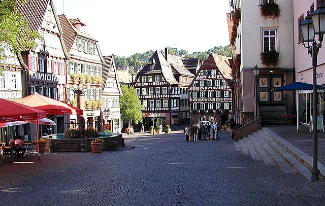
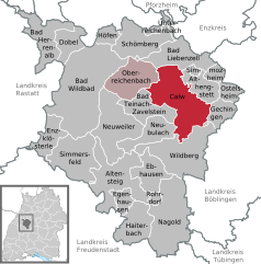
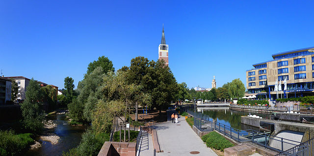
Calw
- city in Baden-Württemberg, Germany
Hiking in Calw
Calw, located in the picturesque Black Forest region of Germany, offers a variety of hiking opportunities for all levels of outdoor enthusiasts. The town is known for its stunning natural landscapes, charming villages, and rich cultural heritage. Here are some highlights of hiking in and around Calw:...
- Country:
- Postal Code: 75365
- Local Dialing Code: 07051
- Licence Plate Code: CW
- Coordinates: 48° 42' 52" N, 8° 44' 15" E
- GPS tracks (wikiloc): [Link]
- AboveSeaLevel: 347 м m
- Area: 59.88 sq km
- Population: 23491
- Web site: [Link]


Bad Teinach-Zavelstein
- town in Baden-Württemberg, Germany
Hiking in Bad Teinach-Zavelstein
Bad Teinach-Zavelstein is a picturesque spa town located in the Schwarzwald (Black Forest) region of Germany. It is surrounded by lush forests, rolling hills, and offers a variety of hiking opportunities that cater to different skill levels. Here are some highlights and tips for hiking in this beautiful area:...
- Country:
- Postal Code: 75385
- Local Dialing Code: 07053
- Licence Plate Code: CW
- Coordinates: 48° 41' 26" N, 8° 41' 34" E
- GPS tracks (wikiloc): [Link]
- AboveSeaLevel: 469 м m
- Area: 25.1 sq km
- Population: 3089
- Web site: [Link]


Bad Liebenzell
- town in Baden-Württemberg, Germany
Hiking in Bad Liebenzell
Bad Liebenzell, located in the picturesque region of the Northern Black Forest in Germany, offers a range of hiking opportunities suitable for all levels of experience. The area is known for its beautiful landscapes, serene valleys, and charming villages. Here are several highlights for hiking in and around Bad Liebenzell:...
- Country:
- Postal Code: 75378
- Local Dialing Code: 07052
- Licence Plate Code: CW
- Coordinates: 48° 46' 27" N, 8° 43' 53" E
- GPS tracks (wikiloc): [Link]
- AboveSeaLevel: 333 м m
- Area: 33.8 sq km
- Population: 9298
- Web site: [Link]


Oberreichenbach
- municipality in Baden-Württemberg, Germany
Hiking in Oberreichenbach
Oberreichenbach, located in Baden-Württemberg, is a beautiful area for hiking, offering a mix of scenic landscapes, dense forests, and charming villages. Here are some key points to consider when planning a hike in this region:...
- Country:
- Postal Code: 75394
- Local Dialing Code: 07051
- Licence Plate Code: CW
- Coordinates: 48° 44' 3" N, 8° 39' 52" E
- GPS tracks (wikiloc): [Link]
- AboveSeaLevel: 626 м m
- Area: 35.99 sq km
- Population: 2836
- Web site: [Link]


Unterreichenbach
- municipality in Baden-Württemberg, Germany
Hiking in Unterreichenbach
Unterreichenbach is a picturesque village located in the North Black Forest region of Germany. It offers a range of hiking opportunities suitable for different skill levels, making it a great destination for outdoor enthusiasts....
- Country:
- Postal Code: 75399
- Local Dialing Code: 07235
- Licence Plate Code: CW
- Coordinates: 48° 50' 0" N, 8° 43' 0" E
- GPS tracks (wikiloc): [Link]
- AboveSeaLevel: 328 м m
- Area: 6.3 sq km
- Population: 2395
- Web site: [Link]

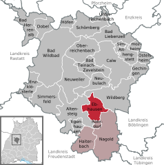
Ebhausen
- municipality in Baden-Württemberg, Germany
Hiking in Ebhausen
Ebhausen is a charming municipality located in the state of Baden-Württemberg, Germany, and it offers a variety of hiking opportunities in and around the region. Nestled in the picturesque landscape of the Swabian Jura and surrounded by forests and scenic countryside, it is an ideal destination for hikers of all skill levels....
- Country:
- Postal Code: 72224
- Local Dialing Code: 07054; 07458
- Licence Plate Code: CW
- Coordinates: 48° 35' 0" N, 8° 41' 0" E
- GPS tracks (wikiloc): [Link]
- AboveSeaLevel: 462 м m
- Area: 24.56 sq km
- Population: 4739
- Web site: [Link]

Neubulach
- town in Baden-Württemberg, Germany
Hiking in Neubulach
Neubulach is a charming town located in the northern Black Forest region of Germany. It offers a variety of scenic hiking opportunities for outdoor enthusiasts of all skill levels. Here are some key points to consider when hiking in and around Neubulach:...
- Country:
- Postal Code: 75387
- Local Dialing Code: 07053
- Licence Plate Code: CW
- Coordinates: 48° 39' 40" N, 8° 41' 48" E
- GPS tracks (wikiloc): [Link]
- AboveSeaLevel: 584 м m
- Area: 24.69 sq km
- Population: 5470
- Web site: [Link]
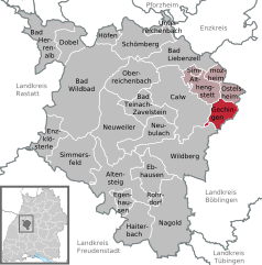
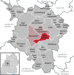
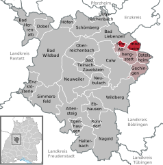
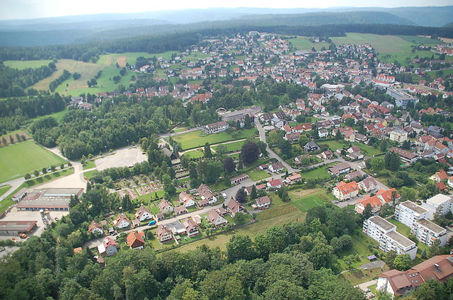
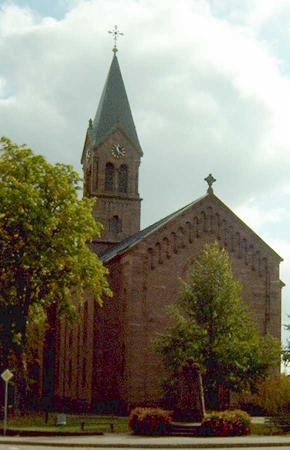
Ostelsheim
- municipality in Baden-Württemberg, Germany
Hiking in Ostelsheim
Ostelsheim is a charming village located in the northern Black Forest region of Germany. It offers a variety of hiking opportunities that cater to different skill levels and preferences. Here are some details about hiking in Ostelsheim:...
- Country:
- Postal Code: 75395
- Local Dialing Code: 07033
- Licence Plate Code: CW
- Coordinates: 48° 43' 35" N, 8° 50' 53" E
- GPS tracks (wikiloc): [Link]
- AboveSeaLevel: 460 м m
- Area: 9.23 sq km
- Population: 2338
- Web site: [Link]

Simmozheim
- municipality in Baden-Württemberg, Germany
Hiking in Simmozheim
Simmozheim, a quaint village in the Enzkreis district of Baden-Württemberg, Germany, offers charming landscapes and a variety of hiking opportunities for outdoor enthusiasts. Here are some highlights of hiking in and around Simmozheim:...
- Country:
- Postal Code: 75397
- Local Dialing Code: 07033
- Licence Plate Code: CW
- Coordinates: 48° 45' 5" N, 8° 48' 41" E
- GPS tracks (wikiloc): [Link]
- AboveSeaLevel: 483 м m
- Area: 9.5 sq km
- Population: 2882
- Web site: [Link]
Neuweiler
- municipality in Baden-Württemberg, Germany
Hiking in Neuweiler
Neuweiler is a charming area located in the Black Forest region of Germany, known for its stunning landscapes, lush forests, and serene hiking trails. Here’s what you should know about hiking in Neuweiler:...
- Country:
- Postal Code: 75389
- Local Dialing Code: 07055
- Licence Plate Code: CW
- Coordinates: 48° 39' 29" N, 8° 35' 53" E
- GPS tracks (wikiloc): [Link]
- AboveSeaLevel: 642 м m
- Area: 51.3 sq km
- Population: 3126
- Web site: [Link]

Schömberg
- municipality in the district of Calw, Baden-Württemberg, Germany
Hiking in Schömberg
Schömberg, located in the Calw district of Baden-Württemberg, Germany, is a lovely destination for hiking enthusiasts. Nestled in the beautiful Black Forest region, it offers a variety of trails suitable for all levels of hikers, from leisurely walks to more challenging hikes....
- Country:
- Postal Code: 75328
- Local Dialing Code: 07235; 07084
- Licence Plate Code: CW
- Coordinates: 48° 47' 12" N, 8° 38' 39" E
- GPS tracks (wikiloc): [Link]
- AboveSeaLevel: 650 м m
- Area: 37.22 sq km
- Population: 7987
- Web site: [Link]


Rohrdorf
- municipality in Baden-Württemberg, Germany
Hiking in Rohrdorf
Rohrdorf, located in the picturesque region of Baden-Württemberg in Germany, offers a wonderful opportunity for hiking enthusiasts. The area is known for its lush landscapes, rolling hills, and scenic views, making it an excellent destination for both casual walkers and serious hikers....
- Country:
- Postal Code: 72229
- Local Dialing Code: 07452
- Licence Plate Code: CW
- Coordinates: 48° 34' 8" N, 8° 41' 40" E
- GPS tracks (wikiloc): [Link]
- AboveSeaLevel: 418 м m
- Area: 3.93 sq km
- Population: 1894
- Web site: [Link]
Altensteig VVG
- agreed administrative community in the district Landkreis Calw, Baden-Württemberg, Germany
Hiking in Altensteig VVG
Altensteig, located in the northern Black Forest region of Germany, is a great destination for hiking enthusiasts. The area offers a variety of trails that range from easy walks to more challenging hikes, catering to different skill levels....
- Country:

Bad Herrenalb VVG
- agreed administrative community in the district Landkreis Calw, Baden-Württemberg, Germany
Hiking in Bad Herrenalb VVG
Bad Herrenalb is a beautiful spa town located in the northern Black Forest region of Germany. It's an excellent destination for hiking enthusiasts, offering a range of trails that cater to various skill levels. Here are some highlights about hiking in Bad Herrenalb:...
- Country:

Bad Wildbad VVG
- agreed administrative community in the district Landkreis Calw, Baden-Württemberg, Germany
Hiking in Bad Wildbad VVG
Bad Wildbad, located in the Black Forest region of Germany, is a fantastic destination for hiking enthusiasts. The area offers a variety of trails that cater to different skill levels, from leisurely walks to more challenging hikes. Here are some highlights of hiking in Bad Wildbad:...
- Country:
Shares border with regions:

Pforzheim
- German city
Hiking in Pforzheim
Pforzheim, located in the northern part of the Black Forest in Germany, offers a variety of hiking opportunities that cater to different skill levels. The region is characterized by its lush forests, picturesque landscapes, and scenic trails....
- Country:
- Postal Code: 75172–75181
- Local Dialing Code: 07231; 07234
- Licence Plate Code: PF
- Coordinates: 48° 54' 0" N, 8° 43' 0" E
- GPS tracks (wikiloc): [Link]
- AboveSeaLevel: 273 м m
- Area: 98.07 sq km
- Population: 123493
- Web site: [Link]


Rastatt
- administrative district in Baden-Württemberg, Germany
Hiking in Rastatt
Rastatt district, located in the state of Baden-Württemberg, Germany, offers a variety of hiking opportunities, particularly due to its proximity to the Black Forest and its diverse landscapes. Here are some highlights and tips for hiking in the Rastatt district:...
- Country:
- Capital: Rastatt
- Licence Plate Code: RA; BH
- Coordinates: 48° 48' 0" N, 8° 16' 12" E
- GPS tracks (wikiloc): [Link]
- AboveSeaLevel: 236 м m
- Area: 738.75 sq km
- Population: 227474
- Web site: [Link]

Enz
- district of Baden-Württemberg, Germany
Hiking in Enz
Enzkreis, located in Baden-Württemberg, Germany, is a wonderful area for hiking enthusiasts, offering a mix of picturesque landscapes, historic towns, and diverse trail options. Here’s an overview of some aspects to consider when hiking in this region:...
- Country:
- Capital: Pforzheim
- Licence Plate Code: PF
- Coordinates: 48° 54' 0" N, 8° 45' 0" E
- GPS tracks (wikiloc): [Link]
- AboveSeaLevel: 298 м m
- Area: 573.69 sq km
- Web site: [Link]


Böblingen
- district of Baden-Württemberg, Germany
Hiking in Böblingen
Böblingen, located in Baden-Württemberg, Germany, is surrounded by beautiful landscapes, making it an excellent area for hiking enthusiasts. The district features various trails that cater to different skill levels, from casual walks to more challenging hikes....
- Country:
- Capital: Böblingen
- Licence Plate Code: LEO; BB
- Coordinates: 48° 42' 0" N, 9° 0' 36" E
- GPS tracks (wikiloc): [Link]
- AboveSeaLevel: 444 м m
- Area: 617.82 sq km
- Population: 381281
- Web site: [Link]