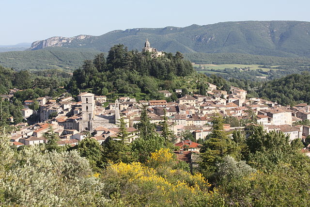
Pierrerue (Pierrerue)
- commune in Alpes-de-Haute-Provence, France
 Hiking in Pierrerue
Pierrerue, located in the Alpes-de-Haute-Provence region of southeastern France, offers a wonderful natural setting for hiking enthusiasts. The area is characterized by stunning landscapes, rolling hills, and a unique blend of Mediterranean and alpine flora. Here are some highlights and tips for hiking in and around Pierrerue:
Trails and Routes
-
Local Trails: There are various marked trails around Pierrerue suitable for different skill levels. Many of these trails wind through picturesque forests, vineyards, and along the banks of the local rivers.
-
GR Trails: The Grande Randonnée (GR) long-distance trails are popular in this region. The GR4 and GR6 pass nearby, providing more extensive hiking opportunities that connect you to other beautiful areas of Provence.
-
Higher Elevations: For those interested in more challenging hikes, the nearby mountains, such as the Lure Mountain Range, offer trails that lead to higher elevations with breathtaking views of the surrounding valleys.
Key Features
-
Natural Beauty: Enjoy the diverse scenery, including rugged cliffs, serene valleys, and unique rock formations. The changing seasons bring different colors and atmospheres, making it a great destination year-round.
-
Flora and Fauna: The region is rich in biodiversity. Keep an eye out for various bird species, wildflowers, and perhaps even deer or foxes on your hikes.
Practical Tips
-
Weather: Check weather conditions before heading out, as they can change rapidly in mountainous regions. Spring and fall are particularly pleasant times to hike in this area.
-
Safety: Make sure to carry plenty of water, snacks, a map or GPS device, and a first-aid kit. Inform someone about your hiking plans, especially for longer routes.
-
Local Customs: Respect the local environment and wildlife. Stay on marked trails and pack out what you bring in.
Nearby Attractions
-
Moustiers-Sainte-Marie: A short drive from Pierrerue, this charming village is famous for its pottery and proximity to the stunning Verdon Gorge, which is great for a day trip or additional hiking experiences.
-
Lavender Fields: Depending on the season, nearby lavender fields are a spectacular sight, particularly from late June to early August.
Hiking in Pierrerue can be an unforgettable experience for nature lovers and adventure seekers alike. Enjoy the beautiful landscapes and the tranquility that this part of France has to offer!
- Country:

- Postal Code: 04300
- Coordinates: 43° 57' 22" N, 5° 49' 58" E


- GPS tracks (wikiloc): [Link]
- Area: 10.86 sq km
- Population: 488
- Web site: http://www.pierrerue.com
- Wikipedia en: wiki(en)
- Wikipedia: wiki(fr)
- Wikidata storage: Wikidata: Q1093022
- Wikipedia Commons Category: [Link]
- Freebase ID: [/m/03m7x4l]
- Freebase ID: [/m/03m7x4l]
- GeoNames ID: Alt: [6425549]
- GeoNames ID: Alt: [6425549]
- SIREN number: [210401519]
- SIREN number: [210401519]
- VIAF ID: Alt: [234333448]
- VIAF ID: Alt: [234333448]
- INSEE municipality code: 04151
- INSEE municipality code: 04151
Shares border with regions:

Lurs
- commune in Alpes-de-Haute-Provence, France
Hiking in Lurs
Lurs, located in the Alpes-de-Haute-Provence region of France, offers a unique and picturesque setting for hiking enthusiasts. This charming village is perched on a hill and is surrounded by beautiful landscapes, including rolling hills, olive groves, and views of the lavender fields that the region is famous for....
- Country:
- Postal Code: 04700
- Coordinates: 43° 58' 10" N, 5° 53' 21" E
- GPS tracks (wikiloc): [Link]
- Area: 22.48 sq km
- Population: 377
Forcalquier
- commune in Alpes-de-Haute-Provence, France
Hiking in Forcalquier
Forcalquier is a charming town located in the Alpes-de-Haute-Provence region of southeastern France. It is surrounded by stunning natural landscapes, making it a great destination for hiking enthusiasts....
- Country:
- Postal Code: 04300
- Coordinates: 43° 57' 33" N, 5° 46' 47" E
- GPS tracks (wikiloc): [Link]
- Area: 42.76 sq km
- Population: 4981
- Web site: [Link]

Sigonce
- commune in Alpes-de-Haute-Provence, France
Hiking in Sigonce
Sigonce, a picturesque village located in the Provence-Alpes-Côte d'Azur region of France, is a hidden gem for outdoor enthusiasts. The surrounding landscape features rolling hills, dense forests, and stunning views that make it an ideal destination for hiking. Here are some highlights and tips for hiking in Sigonce:...
- Country:
- Postal Code: 04300
- Coordinates: 43° 59' 49" N, 5° 50' 25" E
- GPS tracks (wikiloc): [Link]
- Area: 19.97 sq km
- Population: 429
Niozelles
- commune in Alpes-de-Haute-Provence, France
Hiking in Niozelles
Niozelles is a picturesque village located in the Alpes-de-Haute-Provence region of southeastern France. It offers a charming rural landscape, steeped in tranquility and natural beauty, making it a great spot for hiking enthusiasts....
- Country:
- Postal Code: 04300
- Coordinates: 43° 56' 10" N, 5° 50' 15" E
- GPS tracks (wikiloc): [Link]
- Area: 10.47 sq km
- Population: 275