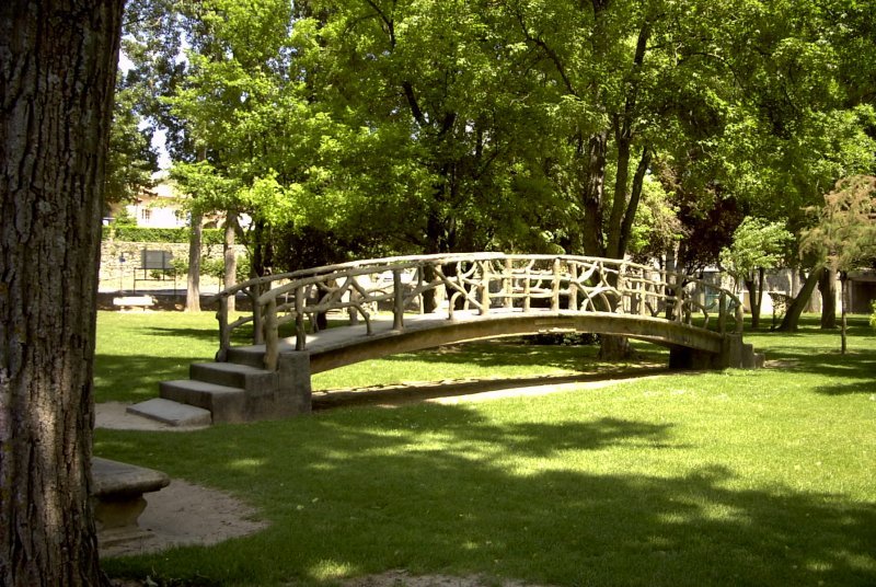
Pierrevert (Pierrevert)
- commune in Alpes-de-Haute-Provence, France
 Hiking in Pierrevert
Pierrevert, located in the picturesque region of Provence-Alpes-Côte d'Azur in France, offers a variety of hiking opportunities set against the backdrop of beautiful landscapes, rolling hills, and Mediterranean vegetation. Here are some key highlights for hiking in Pierrevert:
Scenery and Trails
-
Diverse Terrain: The area features a mix of wooded areas, rocky paths, and open fields, providing hikers with stunning views of the surrounding countryside, vineyards, and typical Provencal scenery.
-
Marked Trails: There are several well-marked hiking trails suitable for different skill levels, ranging from easy walks to more challenging hikes. You can explore routes that lead through natural parks or along scenic ridges.
-
Local Flora and Fauna: Hikers can enjoy the rich biodiversity of the region, including aromatic herbs, wildflowers, and possibly sightings of local wildlife, such as deer and various bird species.
Recommended Hiking Routes
-
Coteaux de Pierrevert Trail: This is a popular path that provides beautiful views of the Durance Valley and the Lubéron mountains. It is suitable for beginners and offers a relatively easy hiking experience.
-
Les Sentiers de Randonnee: This network of trails is accessible from Pierrevert and will take you through enchanting landscapes and quaint villages, allowing you to discover the local culture and history.
Preparation Tips
-
Weather Considerations: The best time to hike in Pierrevert is during the spring (April to June) and fall (September to October) when the weather is mild. Summer can be quite hot, so it’s essential to start early in the day.
-
Hydration and Supplies: Make sure to bring enough water and snacks, especially if you plan on embarking on longer trails.
-
Proper Footwear: Wear sturdy hiking boots or shoes with good grip to navigate the varied terrains comfortably.
Local Amenities
-
Access to Information: Local tourist offices can provide maps, guides, and additional information on hiking routes.
-
Cafés and Restaurants: After a hike, you can enjoy the local cuisine in nearby cafés or restaurants that offer a taste of regional specialties.
Safety Considerations
- Always inform someone of your hiking plans and estimated return time.
- Follow marked paths and pay attention to trail signs to ensure your safety and preserve the natural environment.
Whether you’re seeking a short leisure walk or an adventurous trek, hiking in Pierrevert offers a wonderful opportunity to connect with nature and experience the charm of southern France.
- Country:

- Postal Code: 04860
- Coordinates: 43° 48' 41" N, 5° 44' 58" E


- GPS tracks (wikiloc): [Link]
- Area: 27.9 sq km
- Population: 3672
- Web site: http://www.mairie-pierrevert.fr
- Wikipedia en: wiki(en)
- Wikipedia: wiki(fr)
- Wikidata storage: Wikidata: Q1017916
- Wikipedia Commons Category: [Link]
- Freebase ID: [/m/03m7x4y]
- Freebase ID: [/m/03m7x4y]
- GeoNames ID: Alt: [2987222]
- GeoNames ID: Alt: [2987222]
- SIREN number: [210401527]
- SIREN number: [210401527]
- INSEE municipality code: 04152
- INSEE municipality code: 04152
Shares border with regions:

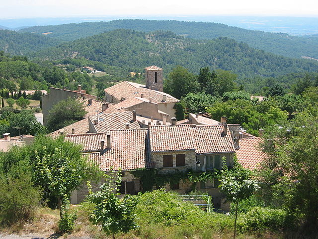
Corbières
- commune in Alpes-de-Haute-Provence, France
Hiking in Corbières
Corbières-en-Provence, located in the stunning Vaucluse region of southern France, offers a unique blend of picturesque landscapes, wine country, and rich cultural heritage, making it a fantastic destination for hiking enthusiasts....
- Country:
- Postal Code: 04220
- Coordinates: 43° 45' 40" N, 5° 45' 5" E
- GPS tracks (wikiloc): [Link]
- Area: 19.06 sq km
- Population: 1161
Sainte-Tulle
- commune in Alpes-de-Haute-Provence, France
Hiking in Sainte-Tulle
Sainte-Tulle is a charming village located in the Alpes-de-Haute-Provence region of France, and it offers some beautiful hiking opportunities for outdoor enthusiasts. Here are some key points to consider if you're planning to hike in and around Sainte-Tulle:...
- Country:
- Postal Code: 04220
- Coordinates: 43° 47' 10" N, 5° 45' 55" E
- GPS tracks (wikiloc): [Link]
- Area: 17.07 sq km
- Population: 3449
- Web site: [Link]
Montfuron
- commune in Alpes-de-Haute-Provence, France
Hiking in Montfuron
Montfuron is a charming village located in the Vaucluse department of southeastern France, nestled in the heart of the Provence region. The area around Montfuron offers beautiful landscapes, making it an attractive destination for hikers and nature enthusiasts....
- Country:
- Postal Code: 04110
- Coordinates: 43° 50' 9" N, 5° 41' 38" E
- GPS tracks (wikiloc): [Link]
- Area: 18.88 sq km
- Population: 214

Manosque
- commune in Alpes-de-Haute-Provence, France
Hiking in Manosque
Manosque, located in the Provence-Alpes-Côte d'Azur region of southeastern France, is surrounded by stunning natural landscapes, making it a fantastic destination for hiking enthusiasts. The area is characterized by its rolling hills, forests, and picturesque villages, offering a variety of trails suitable for different skill levels. Here’s what you need to know about hiking in and around Manosque:...
- Country:
- Postal Code: 04100
- Coordinates: 43° 50' 0" N, 5° 46' 59" E
- GPS tracks (wikiloc): [Link]
- Area: 56.73 sq km
- Population: 21754
- Web site: [Link]


La Bastide-des-Jourdans
- commune in Vaucluse, France
Hiking in La Bastide-des-Jourdans
La Bastide-des-Jourdans is a charming village located in the Provence-Alpes-Côte d'Azur region of southern France, known for its beautiful landscapes, vineyards, and rich history. Hiking in this area offers a great opportunity to explore the stunning natural surroundings and enjoy the peaceful rural ambiance....
- Country:
- Postal Code: 84240
- Coordinates: 43° 47' 7" N, 5° 38' 4" E
- GPS tracks (wikiloc): [Link]
- Area: 27.74 sq km
- Population: 1448


Beaumont-de-Pertuis
- commune in Vaucluse, France
Hiking in Beaumont-de-Pertuis
Beaumont-de-Pertuis, located in the Provence region of France, offers a variety of hiking opportunities amidst beautiful natural landscapes. The area is characterized by its picturesque hills, vineyards, and woodlands, making it a fantastic destination for outdoor enthusiasts....
- Country:
- Postal Code: 84120
- Coordinates: 43° 44' 15" N, 5° 41' 19" E
- GPS tracks (wikiloc): [Link]
- Area: 56.07 sq km
- Population: 1142
- Web site: [Link]