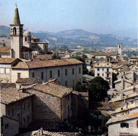
Pietralunga (Pietralunga)
.svg)
- Italian comune
 Hiking in Pietralunga
Pietralunga is a charming town located in the Umbria region of Italy, surrounded by beautiful landscapes that are ideal for hiking enthusiasts. Nestled in the hills, this area is characterized by rolling hills, lush forests, and olive groves, making it a scenic spot for outdoor activities.
Hiking Opportunities:
-
Sentiero di Pietralunga: This is a well-marked hiking trail that offers stunning views of the surrounding countryside. The trail varies in difficulty, so you can choose a route that matches your skill level. Expect to see diverse flora and fauna along the way.
-
Bosco di San Francesco: Located near Pietralunga, this forest area features a network of trails perfect for hiking and nature walks. The trails are surrounded by beautiful woodlands, and you may encounter local wildlife.
-
Monte Cucco Regional Park: A bit further afield, this park offers stunning views and a range of hiking trails. You can hike through limestone landscapes and explore caves.
-
Historical Trails: The region also has trails that connect to historical sites, including old castles, churches, and ancient ruins. These trails provide a cultural context to your hiking experience.
Tips for Hiking in Pietralunga:
- Suitable Footwear: Wear comfortable, sturdy hiking boots to handle varying terrain.
- Hydration: Carry enough water, especially during warmer months.
- Navigation: While many trails are well-marked, a map or a GPS device can be helpful, especially for less-traveled routes.
- Respect Nature: Stay on marked paths, and be mindful of wildlife and the environment.
- Local Weather: Check the weather forecast before heading out, as conditions can change rapidly in the hills.
Best Time to Hike:
The ideal seasons for hiking in Pietralunga are spring (April to June) and fall (September to October), when temperatures are mild, and the landscape is vibrant with colors.
Overall, hiking in Pietralunga offers a blend of natural beauty, adventure, and cultural exploration, making it a rewarding experience for outdoor enthusiasts.
- Country:

- Postal Code: 06026
- Local Dialing Code: 075
- Licence Plate Code: PG
- Coordinates: 43° 27' 0" N, 12° 26' 0" E


- GPS tracks (wikiloc): [Link]
- AboveSeaLevel: 566 м m
- Area: 140.42 sq km
- Population: 2079
- Web site: http://www.pietralunga.it/
- Wikipedia en: wiki(en)
- Wikipedia: wiki(it)
- Wikidata storage: Wikidata: Q20513
- Wikipedia Commons Category: [Link]
- Freebase ID: [/m/0gm2ft]
- GeoNames ID: Alt: [6539744]
- VIAF ID: Alt: [238138231]
- OSM relation ID: [42429]
- UN/LOCODE: [ITP5T]
- ISTAT ID: 054041
- Italian cadastre code: G618
Shares border with regions:


Apecchio
- Italian comune
Hiking in Apecchio
Apecchio is a charming town located in the Marche region of Italy, known for its beautiful landscapes, rolling hills, and rich history. Hiking in Apecchio offers a fantastic experience, with a variety of trails that cater to different skill levels and provide breathtaking views of the surrounding countryside....
- Country:
- Postal Code: 61042
- Local Dialing Code: 0722
- Licence Plate Code: PU
- Coordinates: 43° 33' 33" N, 12° 25' 6" E
- GPS tracks (wikiloc): [Link]
- AboveSeaLevel: 493 м m
- Area: 103.11 sq km
- Population: 1819
- Web site: [Link]

Cagli
- Italian comune
Hiking in Cagli
Cagli, a charming town in the Marche region of Italy, is surrounded by beautiful natural landscapes, making it a great destination for hiking enthusiasts. The area is characterized by rolling hills, lush forests, and scenic views that are perfect for both novice and experienced hikers....
- Country:
- Postal Code: 61043
- Local Dialing Code: 0721
- Licence Plate Code: PU
- Coordinates: 43° 32' 49" N, 12° 38' 50" E
- GPS tracks (wikiloc): [Link]
- AboveSeaLevel: 276 м m
- Area: 226.46 sq km
- Population: 8546
- Web site: [Link]


Città di Castello
- Italian comune
Hiking in Città di Castello
Città di Castello, located in the Umbria region of Italy, is surrounded by stunning landscapes, making it a great destination for hiking enthusiasts. Here are some key points about hiking in and around Città di Castello:...
- Country:
- Postal Code: 06018; 06010; 06012
- Local Dialing Code: 075
- Licence Plate Code: PG
- Coordinates: 43° 27' 27" N, 12° 14' 25" E
- GPS tracks (wikiloc): [Link]
- AboveSeaLevel: 288 м m
- Area: 387.32 sq km
- Population: 39632
- Web site: [Link]
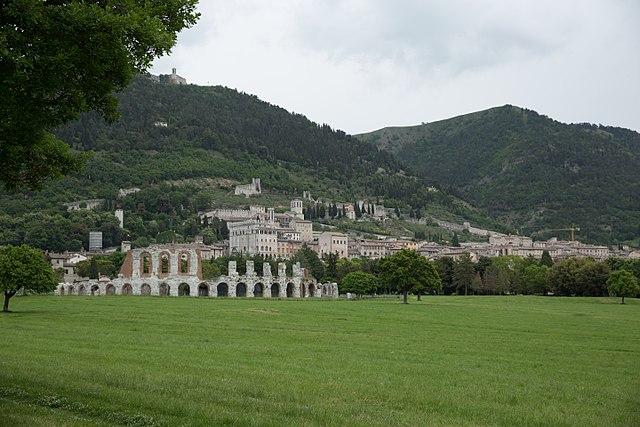

Gubbio
- Italian comune
Hiking in Gubbio
Gubbio, located in the Umbria region of Italy, is surrounded by beautiful landscapes that offer numerous hiking opportunities. Known for its medieval architecture, historical significance, and stunning views, Gubbio provides both charming trails and natural beauty for hikers of all levels. Here are some highlights of hiking in this area:...
- Country:
- Postal Code: 06020; 06024
- Local Dialing Code: 075
- Licence Plate Code: PG
- Coordinates: 43° 21' 6" N, 12° 34' 38" E
- GPS tracks (wikiloc): [Link]
- AboveSeaLevel: 522 м m
- Area: 525.78 sq km
- Population: 31939
- Web site: [Link]

Montone
- Italian comune
Hiking in Montone
Montone is a picturesque village situated in the Umbria region of Italy. Nestled in the hills, it offers a beautiful backdrop for hiking enthusiasts. Here are some key points to consider when hiking in and around Montone:...
- Country:
- Postal Code: 06014
- Local Dialing Code: 075
- Licence Plate Code: PG
- Coordinates: 43° 21' 39" N, 12° 19' 24" E
- GPS tracks (wikiloc): [Link]
- AboveSeaLevel: 482 м m
- Area: 51.1 sq km
- Population: 1642
- Web site: [Link]

Umbertide
- Italian comune
Hiking in Umbertide
Umbertide, located in the Umbria region of Italy, offers a picturesque setting for hiking enthusiasts, with its rolling hills, lush countryside, and charming medieval villages. Here are some highlights and tips for hiking in and around Umbertide:...
- Country:
- Postal Code: 06019
- Local Dialing Code: 075
- Licence Plate Code: PG
- Coordinates: 43° 18' 20" N, 12° 20' 12" E
- GPS tracks (wikiloc): [Link]
- AboveSeaLevel: 247 м m
- Area: 200.83 sq km
- Population: 16530
- Web site: [Link]