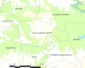
Pisieu (Pisieu)

- commune in Isère, France
 Hiking in Pisieu
Pisieu, a commune located in the Auvergne-Rhône-Alpes region of France, offers beautiful landscapes and opportunities for hiking enthusiasts. While it may not be as widely known as some larger hiking destinations, it provides access to picturesque trails through the surrounding natural areas.
Hiking Trails and Nearby Areas:
-
Forests and Hills: The region around Pisieu features rolling hills and forests that are ideal for hiking. You can discover a variety of trails that offer beautiful views of the landscape.
-
Grand Chartreuse: Nearby, the Chartreuse Mountains provide more extensive hiking opportunities. The famous Grand Chartreuse monastery is located in this area, known for its serene beauty and rich history.
-
Mont Granier: A short distance away, Mont Granier offers hikes with rewarding panoramas. Trails vary in difficulty, making it suitable for both beginners and experienced hikers.
-
Isère River Trails: Along the Isère River, you can find several paths that are great for leisurely walks or more challenging hikes, depending on how deep you venture into winding terrain.
Preparation and Safety:
- Weather Conditions: Always check the weather forecast before heading out, as it can change rapidly in mountainous regions.
- Proper Gear: Wear sturdy hiking boots, and bring a map or GPS device, sufficient water, snacks, and appropriate clothing for changing temperatures.
- Trail Markings: Familiarize yourself with trail markings (GR, PR, and other local signs) to navigate effectively.
Local Culture and Tips:
- Cultural Sites: Consider exploring local cultural sites or enjoying regional cuisine in nearby towns after your hike.
- Respect Nature: Stay on marked paths and follow Leave No Trace principles to preserve the natural beauty of the area.
Hiking in and around Pisieu can be a delightful experience, with the combination of natural beauty and the cultural richness of the Auvergne-Rhône-Alpes region. Enjoy your adventure!
- Country:

- Postal Code: 38270
- Coordinates: 45° 23' 14" N, 5° 3' 37" E


- GPS tracks (wikiloc): [Link]
- Area: 18.76 sq km
- Population: 538
- Web site: http://www.pisieu.fr/
- Wikipedia en: wiki(en)
- Wikipedia: wiki(fr)
- Wikidata storage: Wikidata: Q1068837
- Wikipedia Commons Category: [Link]
- Freebase ID: [/m/03nvl2p]
- GeoNames ID: Alt: [6433286]
- SIREN number: [213803075]
- BnF ID: [15258119v]
- VIAF ID: Alt: [235236742]
- INSEE municipality code: 38307
Shares border with regions:

Saint-Julien-de-l'Herms
- commune in Isère, France
Hiking in Saint-Julien-de-l'Herms
Saint-Julien-de-l'Herms is a charming village located in the French Alps, known for its stunning natural landscapes and outdoor recreational opportunities....
- Country:
- Postal Code: 38122
- Coordinates: 45° 25' 57" N, 5° 5' 40" E
- GPS tracks (wikiloc): [Link]
- Area: 9.17 sq km
- Population: 144


Pommier-de-Beaurepaire
- commune in Isère, France
Hiking in Pommier-de-Beaurepaire
Pommier-de-Beaurepaire is a small commune in the Auvergne-Rhône-Alpes region of France, known for its scenic landscapes and rural charm. While it may not be as well-known as some major hiking destinations, it offers opportunities for outdoor enthusiasts to explore the beauty of the surrounding countryside....
- Country:
- Postal Code: 38260
- Coordinates: 45° 24' 0" N, 5° 7' 11" E
- GPS tracks (wikiloc): [Link]
- Area: 19.16 sq km
- Population: 710

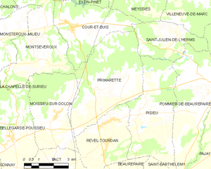
Primarette
- commune in Isère, France
Hiking in Primarette
It seems there might be a typo or misunderstanding regarding "Primarette." I am not familiar with a specific hiking location by that name. However, if you meant a different location, such as a national park, region, or trail, please clarify, and I’d be happy to provide information on hiking in that area!...
- Country:
- Postal Code: 38270
- Coordinates: 45° 24' 7" N, 5° 1' 49" E
- GPS tracks (wikiloc): [Link]
- Area: 21.76 sq km
- Population: 724
- Web site: [Link]


Revel-Tourdan
- commune in Isère, France
Hiking in Revel-Tourdan
Revel-Tourdan, located in the Auvergne-Rhône-Alpes region of southeastern France, offers a picturesque setting for hiking enthusiasts. The area is known for its rolling hills, charming rural landscapes, and access to the rugged beauty of the surrounding mountains....
- Country:
- Postal Code: 38270
- Coordinates: 45° 23' 4" N, 5° 2' 14" E
- GPS tracks (wikiloc): [Link]
- Area: 11.62 sq km
- Population: 1042
- Web site: [Link]


Saint-Barthélemy
- commune in Isère, France
Hiking in Saint-Barthélemy
Saint-Barthélemy is a beautiful commune in the Isère department of the Auvergne-Rhône-Alpes region in southeastern France. Known for its picturesque landscapes, hiking in this area can vary from gentle strolls to more challenging hikes that reward adventurers with stunning views of the surrounding Alps and valleys....
- Country:
- Postal Code: 38270
- Coordinates: 45° 20' 47" N, 5° 4' 49" E
- GPS tracks (wikiloc): [Link]
- Area: 7.98 sq km
- Population: 962
- Web site: [Link]

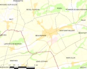
Beaurepaire
- commune in Isère, France
Hiking in Beaurepaire
Beaurepaire, located in the Isère department of France, is a charming commune that offers a variety of hiking opportunities. Nestled in the Rhône-Alpes region, it's surrounded by beautiful landscapes, including rolling hills and valleys, making it a great spot for outdoor enthusiasts....
- Country:
- Postal Code: 38270
- Coordinates: 45° 20' 18" N, 5° 3' 16" E
- GPS tracks (wikiloc): [Link]
- Area: 18.46 sq km
- Population: 4891
- Web site: [Link]