Pommier-de-Beaurepaire (Pommier-de-Beaurepaire)

- commune in Isère, France
 Hiking in Pommier-de-Beaurepaire
Pommier-de-Beaurepaire is a small commune in the Auvergne-Rhône-Alpes region of France, known for its scenic landscapes and rural charm. While it may not be as well-known as some major hiking destinations, it offers opportunities for outdoor enthusiasts to explore the beauty of the surrounding countryside.
Hiking Opportunities:
-
Scenic Trails: The region around Pommier-de-Beaurepaire features a variety of trails that wind through picturesque fields, forests, and hillsides. Hiking here can provide a peaceful escape with the chance to enjoy nature and spot local wildlife.
-
Nearby Natural Parks: Consider exploring trails in nearby natural parks or reserves, such as the Parc Naturel Régional du Pilat or Parc Naturel Régional des Volcans d'Auvergne. These parks offer well-marked trails of varying difficulty levels, catering to both beginners and experienced hikers.
-
Cultural Sites: In addition to enjoying nature, hikes in the area can connect you to local heritage. Look for trails that may lead to quaint villages, historical landmarks, and traditional farms, allowing for a deeper understanding of the local culture.
Tips for Hiking in the Area:
- Weather Check: Always check the weather forecast before heading out, as conditions can change rapidly in the mountains.
- Proper Gear: Wear comfortable hiking shoes, dress in layers, and bring a backpack with essentials like water, snacks, a map, and a first-aid kit.
- Safety Precautions: Inform someone about your hiking plan, and ensure you have a charged mobile phone. If hiking in more remote areas, consider carrying a portable charger.
- Respect Nature: Follow Leave No Trace principles, the local regulations, and respect wildlife habitats during your hike.
Getting There:
Pommier-de-Beaurepaire is accessible by car and may have limited public transportation options. It’s best to plan your travel in advance, especially if you're coming from major cities like Lyon or Saint-Étienne.
In summary, while Pommier-de-Beaurepaire may be a quieter hiking destination, it can offer rewarding experiences for those looking to explore the natural beauty and tranquility of this region in France. Happy hiking!
- Country:

- Postal Code: 38260
- Coordinates: 45° 24' 0" N, 5° 7' 11" E


- GPS tracks (wikiloc): [Link]
- Area: 19.16 sq km
- Population: 710
- Wikipedia en: wiki(en)
- Wikipedia: wiki(fr)
- Wikidata storage: Wikidata: Q1068558
- Wikipedia Commons Category: [Link]
- Freebase ID: [/m/03nvj6j]
- GeoNames ID: Alt: [6433289]
- SIREN number: [213803117]
- BnF ID: [152581233]
- INSEE municipality code: 38311
Shares border with regions:

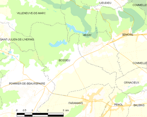
Bossieu
- commune in Isère, France
Hiking in Bossieu
Bossieu, a small commune in the Isère department of southeastern France, offers some charming opportunities for hiking enthusiasts. The region is characterized by its picturesque landscapes, which include rolling hills, forests, and views of the surrounding mountains....
- Country:
- Postal Code: 38260
- Coordinates: 45° 25' 1" N, 5° 8' 53" E
- GPS tracks (wikiloc): [Link]
- Area: 13.48 sq km
- Population: 281
- Web site: [Link]

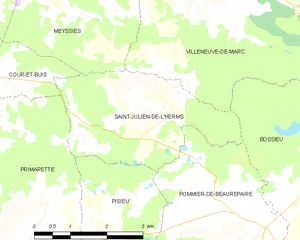
Saint-Julien-de-l'Herms
- commune in Isère, France
Hiking in Saint-Julien-de-l'Herms
Saint-Julien-de-l'Herms is a charming village located in the French Alps, known for its stunning natural landscapes and outdoor recreational opportunities....
- Country:
- Postal Code: 38122
- Coordinates: 45° 25' 57" N, 5° 5' 40" E
- GPS tracks (wikiloc): [Link]
- Area: 9.17 sq km
- Population: 144


Pisieu
- commune in Isère, France
Hiking in Pisieu
Pisieu, a commune located in the Auvergne-Rhône-Alpes region of France, offers beautiful landscapes and opportunities for hiking enthusiasts. While it may not be as widely known as some larger hiking destinations, it provides access to picturesque trails through the surrounding natural areas....
- Country:
- Postal Code: 38270
- Coordinates: 45° 23' 14" N, 5° 3' 37" E
- GPS tracks (wikiloc): [Link]
- Area: 18.76 sq km
- Population: 538
- Web site: [Link]


Pajay
- commune in Isère, France
Hiking in Pajay
Pajay, likely referring to a less commonly known hiking area, might not have extensive resources or documented trails like more popular hiking destinations. However, if Pajay is situated in a mountainous or nature-rich region, I can guide you on typical hiking experiences that such areas might offer....
- Country:
- Postal Code: 38260
- Coordinates: 45° 21' 50" N, 5° 8' 22" E
- GPS tracks (wikiloc): [Link]
- Area: 14.32 sq km
- Population: 1126
- Web site: [Link]
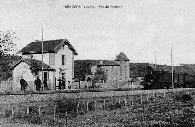

Beaufort
- commune in Isère, France
Hiking in Beaufort
Beaufort, located in the Isère department of the Auvergne-Rhône-Alpes region in southeastern France, is a charming area known for its stunning alpine scenery and diverse hiking opportunities. Here are some highlights about hiking in this region:...
- Country:
- Postal Code: 38270
- Coordinates: 45° 19' 35" N, 5° 7' 19" E
- GPS tracks (wikiloc): [Link]
- AboveSeaLevel: 280 м m
- Area: 8.69 sq km
- Population: 564
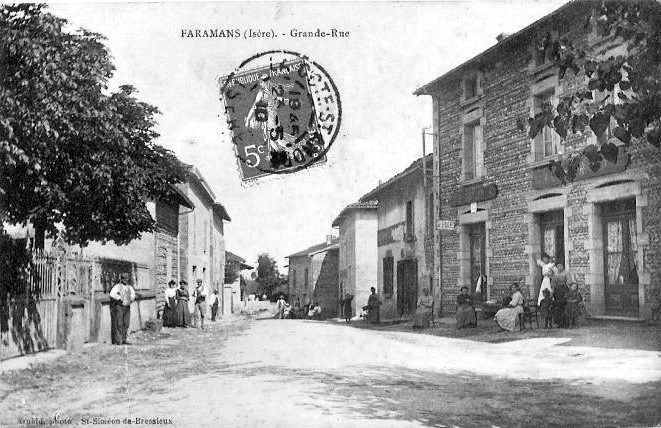

Faramans
- commune in Isère, France
Hiking in Faramans
Faramans is a small commune located in the Isère department in the Auvergne-Rhône-Alpes region of southeastern France. While it may not be as well-known as some of the larger hiking destinations in the area, it offers beautiful landscapes and a chance to enjoy nature in a quieter setting....
- Country:
- Postal Code: 38260
- Coordinates: 45° 23' 36" N, 5° 9' 49" E
- GPS tracks (wikiloc): [Link]
- Area: 10.79 sq km
- Population: 1017
- Web site: [Link]


Saint-Barthélemy
- commune in Isère, France
Hiking in Saint-Barthélemy
Saint-Barthélemy is a beautiful commune in the Isère department of the Auvergne-Rhône-Alpes region in southeastern France. Known for its picturesque landscapes, hiking in this area can vary from gentle strolls to more challenging hikes that reward adventurers with stunning views of the surrounding Alps and valleys....
- Country:
- Postal Code: 38270
- Coordinates: 45° 20' 47" N, 5° 4' 49" E
- GPS tracks (wikiloc): [Link]
- Area: 7.98 sq km
- Population: 962
- Web site: [Link]