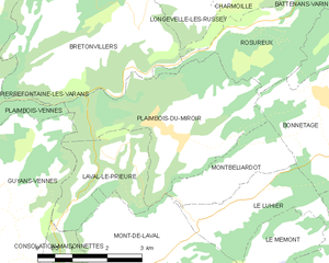
Plaimbois-Vennes (Plaimbois-Vennes)

- commune in Doubs, France
 Hiking in Plaimbois-Vennes
Plaimbois-Vennes is a charming commune located in the Doubs department in the Bourgogne-Franche-Comté region of eastern France. Nestled in the picturesque landscapes of the Jura Mountains, this area is known for its natural beauty, making it an excellent destination for hiking enthusiasts.
Hiking Trails:
-
Local Trails: The region around Plaimbois-Vennes features a range of hiking trails suitable for varying skill levels. You'll find well-marked paths that meander through forests, meadows, and along streams, offering both challenging hikes and easier strolls.
-
Jura Mountains: The nearby Jura Mountains provide more extensive hiking opportunities, with stunning views and diverse terrain. Trails in this area often feature ridges, deep valleys, and unique geological formations.
-
Lakes and Views: Hikes often lead to scenic viewpoints or picturesque lakes, such as Lake Saint-Point and Lake Antior. These spots are perfect for taking a break and enjoying a picnic or simply soaking in the natural surroundings.
Hiking Tips:
- Weather: Always check the weather before heading out, as conditions can change rapidly in mountainous regions. Dress in layers to stay comfortable.
- Gear: Good hiking boots are essential, and don’t forget a map or a GPS device. Trekking poles can also help with steep or uneven terrain.
- Safety: Inform someone of your hiking plans, especially if you’re heading into less trafficked areas. Carry enough water and snacks to keep your energy up.
Local Flora and Fauna:
While hiking, watch for local wildlife, including deer and various bird species. The flora varies with the elevation, featuring everything from lush forests to alpine meadows filled with wildflowers.
Conclusion:
Hiking in and around Plaimbois-Vennes is a rewarding experience, offering opportunities to immerse yourself in nature and enjoy the rich biodiversity of the region. Whether you’re a seasoned hiker or just looking for a leisurely walk, the scenic trails in this part of France are sure to impress. Always remember to respect the environment and leave no trace while exploring this beautiful landscape.
- Country:

- Postal Code: 25390
- Coordinates: 47° 11' 2" N, 6° 32' 26" E


- GPS tracks (wikiloc): [Link]
- Area: 10.8 sq km
- Population: 102
- Wikipedia en: wiki(en)
- Wikipedia: wiki(fr)
- Wikidata storage: Wikidata: Q907023
- Wikipedia Commons Category: [Link]
- Freebase ID: [/m/03mgy4j]
- Freebase ID: [/m/03mgy4j]
- GeoNames ID: Alt: [6429941]
- GeoNames ID: Alt: [6429941]
- SIREN number: [212504575]
- SIREN number: [212504575]
- BnF ID: [15252683w]
- BnF ID: [15252683w]
- VIAF ID: Alt: [129464932]
- VIAF ID: Alt: [129464932]
- Library of Congress authority ID: Alt: [nr96036186]
- Library of Congress authority ID: Alt: [nr96036186]
- INSEE municipality code: 25457
- INSEE municipality code: 25457
Shares border with regions:


La Sommette
- commune in Doubs, France
Hiking in La Sommette
La Sommette is a beautiful hiking destination located in the French Alps, specifically in the region of Savoie. It offers stunning views, diverse landscapes, and a variety of trails suitable for hikers of different skill levels....
- Country:
- Postal Code: 25510
- Coordinates: 47° 11' 32" N, 6° 30' 38" E
- GPS tracks (wikiloc): [Link]
- Area: 7.37 sq km
- Population: 231


Vennes
- commune in Doubs, France
Hiking in Vennes
Vennes, located in Norway, is known for its stunning natural beauty and diverse hiking opportunities. With breathtaking landscapes, including fjords, mountains, and forests, it offers a variety of trails suitable for all experience levels. Here are some highlights to consider when hiking in Vennes:...
- Country:
- Postal Code: 25390
- Coordinates: 47° 9' 10" N, 6° 32' 50" E
- GPS tracks (wikiloc): [Link]
- AboveSeaLevel: 850 м m
- Area: 7.31 sq km
- Population: 155


Bretonvillers
- commune in Doubs, France
Hiking in Bretonvillers
Bretonvillers is a charming village located in the Franche-Comté region of eastern France, known for its picturesque landscapes and natural beauty. If you’re considering hiking in and around Bretonvillers, here are some points to keep in mind:...
- Country:
- Postal Code: 25380
- Coordinates: 47° 13' 5" N, 6° 38' 13" E
- GPS tracks (wikiloc): [Link]
- Area: 13.66 sq km
- Population: 275


Pierrefontaine-les-Varans
- commune in Doubs, France
Hiking in Pierrefontaine-les-Varans
Pierrefontaine-les-Varans, located in the Doubs department in the Bourgogne-Franche-Comté region of France, offers a variety of hiking opportunities that showcase its beautiful landscapes and local culture. Nestled in the Jura Mountains, the area is characterized by rolling hills, lush forests, and charming rural scenery. Here are some highlights and tips for hiking in and around Pierrefontaine-les-Varans:...
- Country:
- Postal Code: 25510
- Coordinates: 47° 12' 55" N, 6° 32' 19" E
- GPS tracks (wikiloc): [Link]
- Area: 28.9 sq km
- Population: 1394


Loray
- commune in Doubs, France
Hiking in Loray
It seems like there may be a mix-up with the name "Loray," as it does not appear to be a widely recognized hiking destination. However, if you were referring to an area near Loray or a specific park or region within a locality, please clarify....
- Country:
- Postal Code: 25390
- Coordinates: 47° 9' 11" N, 6° 29' 44" E
- GPS tracks (wikiloc): [Link]
- Area: 14.39 sq km
- Population: 491

Plaimbois-du-Miroir
- commune in Doubs, France
Hiking in Plaimbois-du-Miroir
Plaimbois-du-Miroir is a charming village located in the Jura region of France, known for its picturesque landscapes and outdoor activities, including hiking. The Jura Mountains offer a variety of trails that cater to hikers of different skill levels. Here are some highlights:...
- Country:
- Postal Code: 25210
- Coordinates: 47° 11' 29" N, 6° 38' 43" E
- GPS tracks (wikiloc): [Link]
- Area: 11.71 sq km
- Population: 238

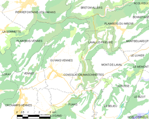
Guyans-Vennes
- commune in Doubs, France
Hiking in Guyans-Vennes
Guyans-Vennes is a quaint municipality located in the Jura region of France, known for its beautiful natural landscapes and opportunities for hiking enthusiasts. Here are some key points to consider when hiking in and around Guyans-Vennes:...
- Country:
- Postal Code: 25390
- Coordinates: 47° 9' 23" N, 6° 34' 15" E
- GPS tracks (wikiloc): [Link]
- Area: 19.67 sq km
- Population: 816