Plesder (Plesder)

- commune in Ille-et-Vilaine, France
- Country:

- Postal Code: 35720
- Coordinates: 48° 24' 49" N, 1° 55' 21" E


- GPS tracks (wikiloc): [Link]
- Area: 11.03 sq km
- Population: 783
- Wikipedia en: wiki(en)
- Wikipedia: wiki(fr)
- Wikidata storage: Wikidata: Q1074541
- Wikipedia Commons Category: [Link]
- Freebase ID: [/m/03m98_p]
- Freebase ID: [/m/03m98_p]
- Freebase ID: [/m/03m98_p]
- GeoNames ID: Alt: [6432789]
- GeoNames ID: Alt: [6432789]
- GeoNames ID: Alt: [6432789]
- SIREN number: [213502255]
- SIREN number: [213502255]
- SIREN number: [213502255]
- BnF ID: [15257167g]
- BnF ID: [15257167g]
- BnF ID: [15257167g]
- OSM relation ID: [142955]
- OSM relation ID: [142955]
- OSM relation ID: [142955]
- INSEE municipality code: 35225
- INSEE municipality code: 35225
- INSEE municipality code: 35225
Shares border with regions:
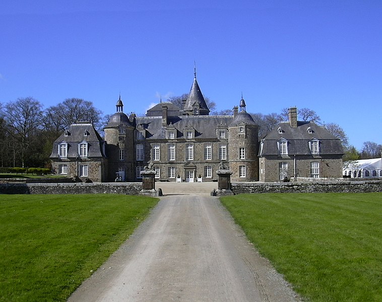
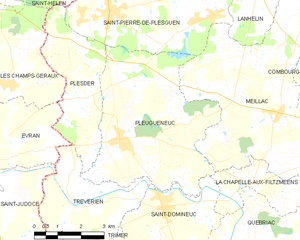
Pleugueneuc
- commune in Ille-et-Vilaine, France
- Country:
- Postal Code: 35720
- Coordinates: 48° 23' 47" N, 1° 54' 13" E
- GPS tracks (wikiloc): [Link]
- Area: 24.52 sq km
- Population: 1838
- Web site: [Link]


Trévérien
- commune in Ille-et-Vilaine, France
- Country:
- Postal Code: 35190
- Coordinates: 48° 22' 15" N, 1° 55' 41" E
- GPS tracks (wikiloc): [Link]
- Area: 12.08 sq km
- Population: 888


Évran
- commune in Côtes-d'Armor, France
- Country:
- Postal Code: 22630
- Coordinates: 48° 22' 57" N, 1° 58' 51" E
- GPS tracks (wikiloc): [Link]
- Area: 23.56 sq km
- Population: 1712
- Web site: [Link]


Saint-Hélen
- commune in Côtes-d'Armor, France
- Country:
- Postal Code: 22100
- Coordinates: 48° 28' 16" N, 1° 57' 32" E
- GPS tracks (wikiloc): [Link]
- Area: 17.02 sq km
- Population: 1439


Saint-Pierre-de-Plesguen
- former commune in Ille-et-Vilaine, France
- Country:
- Postal Code: 35720
- Coordinates: 48° 26' 50" N, 1° 54' 48" E
- GPS tracks (wikiloc): [Link]
- AboveSeaLevel: 82 м m
- Area: 29.49 sq km
- Population: 2846
- Web site: [Link]


Les Champs-Géraux
- commune in Côtes-d'Armor, France
- Country:
- Postal Code: 22630
- Coordinates: 48° 25' 0" N, 1° 58' 14" E
- GPS tracks (wikiloc): [Link]
- Area: 19.09 sq km
- Population: 1042