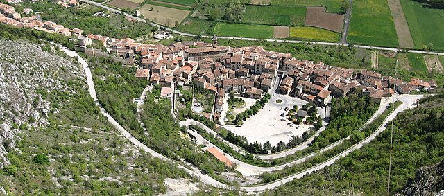
Poggio Picenze (Poggio Picenze)
.svg)
- Italian comune
 Hiking in Poggio Picenze
Poggio Picenze, located in the Abruzzo region of Italy, is a charming destination for hikers. Nestled in the beautiful Apennine Mountains, it provides a scenic backdrop of rolling hills, lush forests, and stunning landscapes. Here are some highlights and tips for hiking in this area:
Trails and Routes
-
Local Trails: The area around Poggio Picenze offers a network of hiking trails catering to various skill levels. You can find paths that lead through forests, meadows, and along the river, providing beautiful views of the surrounding mountains.
-
Gran Sasso National Park: Just a short drive away, this national park features some of the region's most stunning hikes, such as those around the Corno Grande, the highest peak in the Apennines. The park offers trails ranging from easy to challenging.
-
Historical Routes: Some trails may lead to ancient ruins or traditional villages, offering a chance to explore the cultural heritage of the Abruzzo region.
Best Time to Hike
- Spring and Fall: These seasons are ideal for hiking, as temperatures are typically mild and the landscapes are vibrant with greenery or autumn colors.
- Summer: While it's a popular time for hiking, be prepared for warmer temperatures, and stay hydrated. Consider starting hikes early in the morning.
What to Bring
- Proper Footwear: Hiking boots with good grip are essential, especially on rocky or uneven terrain.
- Map and Compass/GPS: Even if trails are marked, having a map handy is always a good idea.
- Clothing: Dress in layers to accommodate changing temperatures, and pack waterproof gear in case of rain.
- Tools and Supplies: Bring enough water, snacks, a first-aid kit, and any personal items you may need.
Local Tips
- Guided Tours: If you're unfamiliar with the area, consider joining a guided hike. Local guides can provide insights into the flora, fauna, and history.
- Respect Nature: Follow Leave No Trace principles to preserve the beauty of the trails and natural environments.
Hiking in Poggio Picenze can be a rewarding experience, combining the beauty of nature with opportunities to immerse yourself in the local culture. Be sure to check local conditions and trail updates before heading out on your adventure!
- Country:

- Postal Code: 67026
- Local Dialing Code: 0862
- Licence Plate Code: AQ
- Coordinates: 42° 19' 14" N, 13° 32' 25" E


- GPS tracks (wikiloc): [Link]
- AboveSeaLevel: 756 м m
- Area: 11.46 sq km
- Population: 1105
- Web site: http://www.comunepoggiopicenze.it/
- Wikipedia en: wiki(en)
- Wikipedia: wiki(it)
- Wikidata storage: Wikidata: Q50126
- Wikipedia Commons Gallery: [Link]
- Wikipedia Commons Category: [Link]
- Freebase ID: [/m/0fg7hx]
- GeoNames ID: Alt: [6537439]
- VIAF ID: Alt: [126866217]
- OSM relation ID: [41947]
- GND ID: Alt: [4551235-8]
- WOEID: [720771]
- Google Maps Customer ID: [10915600821263016134]
- ISTAT ID: 066073
- Italian cadastre code: G766
Shares border with regions:


Barisciano
- Italian comune
Hiking in Barisciano
Barisciano is a charming village located in the Province of L'Aquila, in the Abruzzo region of Italy. The area is known for its stunning landscapes, historical architecture, and proximity to the Gran Sasso e Monti della Laga National Park, making it a fantastic destination for hikers and outdoor enthusiasts....
- Country:
- Postal Code: 67021
- Local Dialing Code: 0862
- Licence Plate Code: AQ
- Coordinates: 42° 19' 31" N, 13° 35' 36" E
- GPS tracks (wikiloc): [Link]
- AboveSeaLevel: 940 м m
- Area: 78.49 sq km
- Population: 1764
- Web site: [Link]

Fossa, Abruzzo
- Italian comune
Hiking in Fossa, Abruzzo
Fossa is a charming village located in the Abruzzo region of Italy, surrounded by stunning natural landscapes that make it an excellent destination for hiking enthusiasts. The area boasts a rich variety of trails that cater to different skill levels, from easy walks to more challenging hikes. Here are some highlights about hiking in and around Fossa:...
- Country:
- Postal Code: 67020
- Local Dialing Code: 0862
- Licence Plate Code: AQ
- Coordinates: 42° 17' 34" N, 13° 29' 16" E
- GPS tracks (wikiloc): [Link]
- AboveSeaLevel: 644 м m
- Area: 8.71 sq km
- Population: 705
- Web site: [Link]


San Demetrio ne' Vestini
- Italian comune
Hiking in San Demetrio ne' Vestini
San Demetrio ne' Vestini is a charming municipality located in the province of L'Aquila in the Abruzzo region of Italy. It's nestled in a mountainous area, making it a wonderful destination for hiking enthusiasts. Here are some highlights about hiking in and around San Demetrio ne' Vestini:...
- Country:
- Postal Code: 67028
- Local Dialing Code: 0862
- Licence Plate Code: AQ
- Coordinates: 42° 17' 26" N, 13° 33' 22" E
- GPS tracks (wikiloc): [Link]
- AboveSeaLevel: 662 м m
- Area: 16.49 sq km
- Population: 1909
- Web site: [Link]


Sant'Eusanio Forconese
- Italian comune
Hiking in Sant'Eusanio Forconese
Sant'Eusanio Forconese is a picturesque village located in the Abruzzo region of Italy, nestled in the Apennine Mountains. This area is known for its breathtaking natural landscapes, rich history, and diverse hiking opportunities. Here are some key points to consider when hiking in Sant'Eusanio Forconese:...
- Country:
- Postal Code: 67020
- Local Dialing Code: 0862
- Licence Plate Code: AQ
- Coordinates: 42° 17' 18" N, 13° 31' 28" E
- GPS tracks (wikiloc): [Link]
- AboveSeaLevel: 591 м m
- Area: 7.94 sq km
- Population: 394
- Web site: [Link]