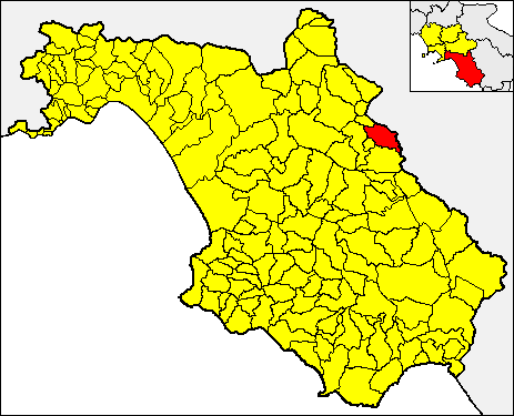
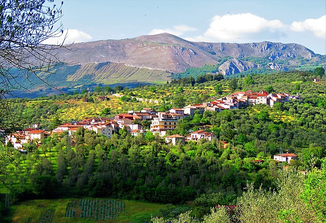
Polla (Polla)

- Italian comune
 Hiking in Polla
Polla, a charming town located in the Campania region of Italy, is often overlooked by tourists but offers a wealth of natural beauty and hiking opportunities. Nestled in the heart of the Alburni Mountains, it serves as an ideal base for those looking to explore scenic trails, lush landscapes, and authentic Italian culture.
Here are some highlights and tips for hiking in and around Polla:
Trails and Natural Areas:
-
Alburni Mountains: The surrounding mountain range offers numerous trails with varying levels of difficulty. You can experience breathtaking views, rugged terrain, and diverse flora and fauna.
-
Sentiero degli Dei (Path of the Gods): While not located precisely in Polla, this famous trail is not far and is renowned for its stunning views of the Amalfi Coast. It's well worth a day trip if you're in the area.
-
Caves and Gorges: The region is known for its natural caves and gorges, such as the Pertosa-Auletta Caves, which provide both hiking options and opportunities for spelunking.
-
Lago di San Pietro: A short hike from Polla leads to this picturesque lake, perfect for a picnic or a lovely spot to rest.
Planning Your Hike:
-
Trail Maps and Guides: It's essential to have a good trail map or guidebook. Local tourist offices often provide resources or can suggest the best hikes suited to your skill level.
-
Weather Considerations: The best time to hike in this region is during the spring (March to June) and the fall (September to November) when temperatures are mild and the scenery is vibrant.
-
Safety: Always carry sufficient water, snacks, a first-aid kit, and wear sturdy hiking boots. If hiking in more remote areas, consider informing someone about your plans.
-
Local Culture: After your hike, take the time to enjoy the local cuisine. Polla has authentic restaurants that serve regional dishes, allowing you to refuel with a taste of Campanian hospitality.
Accessibility:
Polla is well-connected by public transport, though having a car can give you flexibility to explore more remote trailheads. Check local bus schedules or consider joining a guided hiking tour if you're unfamiliar with the area.
Hiking in Polla offers a chance to escape the crowds, experience majestic nature, and enjoy the serene beauty of Southern Italy. Whether you're a seasoned hiker or just starting, you'll find the trails here rewarding and captivating.
- Country:

- Postal Code: 84035
- Local Dialing Code: 0975
- Licence Plate Code: SA
- Coordinates: 40° 31' 0" N, 15° 30' 0" E


- GPS tracks (wikiloc): [Link]
- AboveSeaLevel: 468 м m
- Area: 48.08 sq km
- Population: 5273
- Web site: http://www.comune.polla.sa.it
- Wikipedia en: wiki(en)
- Wikipedia: wiki(it)
- Wikidata storage: Wikidata: Q81333
- Wikipedia Commons Category: [Link]
Shares border with regions:


Brienza
- Italian comune
Hiking in Brienza
Brienza, located in the province of Potenza in the Basilicata region of Italy, is surrounded by beautiful landscapes, making it an excellent destination for hiking enthusiasts. The area features a mix of forested areas, rolling hills, and stunning views of the surrounding mountains....
- Country:
- Postal Code: 85050
- Local Dialing Code: 0975
- Licence Plate Code: PZ
- Coordinates: 40° 28' 43" N, 15° 37' 48" E
- GPS tracks (wikiloc): [Link]
- AboveSeaLevel: 706 м m
- Area: 82.94 sq km
- Population: 4030
- Web site: [Link]
Sant'Angelo Le Fratte
- Italian comune
Hiking in Sant'Angelo Le Fratte
Sant'Angelo Le Fratte is a charming village located in the Basilicata region of southern Italy, known for its stunning landscapes and rich natural beauty. The area offers various hiking opportunities for both novice and seasoned hikers, providing a unique glimpse into the local environment, culture, and history....
- Country:
- Postal Code: 85050
- Local Dialing Code: 0975
- Licence Plate Code: PZ
- Coordinates: 40° 32' 49" N, 15° 33' 27" E
- GPS tracks (wikiloc): [Link]
- AboveSeaLevel: 560 м m
- Area: 23.1 sq km
- Population: 1395
- Web site: [Link]


Atena Lucana
- Italian comune
Hiking in Atena Lucana
Atena Lucana is a charming town located in the province of Salerno, in the Campania region of southern Italy. It is surrounded by the beautiful natural landscape of the Lucanian Apennines and is near the breathtaking Cilento and Vallo di Diano National Park, making it an excellent destination for hiking enthusiasts....
- Country:
- Postal Code: 84030
- Local Dialing Code: 0975
- Licence Plate Code: SA
- Coordinates: 40° 27' 0" N, 15° 33' 0" E
- GPS tracks (wikiloc): [Link]
- AboveSeaLevel: 642 м m
- Area: 26.01 sq km
- Population: 2402
- Web site: [Link]


Auletta
- Italian comune
Hiking in Auletta
Auletta, a small town in the province of Salerno in southern Italy, is surrounded by beautiful landscapes and offers several opportunities for hiking enthusiasts. Nestled in the foothills of the Apennines, Auletta provides access to picturesque trails, rolling hills, and views of the surrounding countryside....
- Country:
- Postal Code: 84031
- Local Dialing Code: 0975
- Licence Plate Code: SA
- Coordinates: 40° 33' 40" N, 15° 25' 28" E
- GPS tracks (wikiloc): [Link]
- AboveSeaLevel: 280 м m
- Area: 35.68 sq km
- Population: 2520
- Web site: [Link]

Caggiano
- Italian comune
Hiking in Caggiano
Caggiano is a charming town located in the province of Salerno, in the Campania region of Italy. It’s positioned in the beautiful Apennine Mountains, which provides a stunning backdrop for hiking enthusiasts. Here are some key points about hiking in and around Caggiano:...
- Country:
- Postal Code: 84030
- Local Dialing Code: 0975
- Licence Plate Code: SA
- Coordinates: 40° 34' 0" N, 15° 30' 0" E
- GPS tracks (wikiloc): [Link]
- AboveSeaLevel: 828 м m
- Area: 35.43 sq km
- Population: 2676
- Web site: [Link]


Corleto Monforte
- Italian comune
Hiking in Corleto Monforte
Corleto Monforte is a charming small town located in the region of Basilicata in southern Italy. This area is characterized by its stunning natural beauty, with a mix of rolling hills, rugged mountains, and beautiful landscapes, making it an excellent destination for hiking enthusiasts....
- Country:
- Postal Code: 84020
- Local Dialing Code: 0828
- Licence Plate Code: SA
- Coordinates: 40° 26' 0" N, 15° 23' 0" E
- GPS tracks (wikiloc): [Link]
- AboveSeaLevel: 683 м m
- Area: 58.97 sq km
- Population: 567
- Web site: [Link]

Pertosa
- Italian comune
Hiking in Pertosa
Hiking in Pertosa, a charming village located in the Campania region of southern Italy, offers a variety of scenic trails and opportunities to explore the beautiful natural landscapes. Here are some highlights and tips for your hiking experience in Pertosa:...
- Country:
- Postal Code: 84030
- Local Dialing Code: 0975
- Licence Plate Code: SA
- Coordinates: 40° 33' 0" N, 15° 27' 0" E
- GPS tracks (wikiloc): [Link]
- AboveSeaLevel: 310 м m
- Area: 6.16 sq km
- Population: 683
- Web site: [Link]
Sant'Arsenio
- Italian comune
Hiking in Sant'Arsenio
Sant'Arsenio, located in the Campania region of Italy, is surrounded by stunning natural landscapes, making it an excellent destination for hiking enthusiasts. The area features the scenic backdrop of the Appennine Mountains, offering varied terrain and a range of trails for hikers of all levels....
- Country:
- Postal Code: 84037
- Local Dialing Code: 0975
- Licence Plate Code: SA
- Coordinates: 40° 28' 0" N, 15° 29' 0" E
- GPS tracks (wikiloc): [Link]
- AboveSeaLevel: 448 м m
- Area: 20.14 sq km
- Population: 2815
- Web site: [Link]