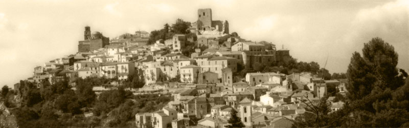
Auletta (Auletta)

- Italian comune
 Hiking in Auletta
Auletta, a small town in the province of Salerno in southern Italy, is surrounded by beautiful landscapes and offers several opportunities for hiking enthusiasts. Nestled in the foothills of the Apennines, Auletta provides access to picturesque trails, rolling hills, and views of the surrounding countryside.
Popular Hiking Trails:
-
Rugged Hill Trails: Explore the hills surrounding Auletta. There are several trails that meander through the countryside, often leading to stunning viewpoints over the valley and surrounding mountains.
-
Cilento National Park: Auletta is located near the Cilento and Vallo di Diano National Park, a UNESCO World Heritage Site. This expansive park features a variety of trails, from easy walks to challenging hikes, showcasing diverse flora and fauna, ancient ruins, as well as scenic coastal views.
-
Valle del Mercure: This area offers more challenging hikes with rugged terrain, waterfalls, and rivers. It's perfect for those looking for adventure and a connection to nature.
Local Tips:
- Preparation: Ensure you wear appropriate hiking gear, including sturdy shoes, and carry plenty of water and snacks.
- Navigation: Some trails may not be well-marked, so having a map or a GPS app is helpful.
- Guided Tours: Consider joining a guided hike for a more informative experience, as local guides can share interesting insights about the flora, fauna, and history of the area.
- Respect Nature: Always practice Leave No Trace principles to preserve the natural beauty of the region.
Best Time to Hike:
The best time to hike in Auletta and surrounding areas is in spring (April to June) and early fall (September to October) when the weather is mild and the scenery is vibrant with wildflowers and foliage.
If you're planning a trip, take some time to explore Auletta's local culture, cuisine, and heritage. The town's charm and the breathtaking natural surroundings make it a wonderful hiking destination. Happy hiking!
- Country:

- Postal Code: 84031
- Local Dialing Code: 0975
- Licence Plate Code: SA
- Coordinates: 40° 33' 40" N, 15° 25' 28" E


- GPS tracks (wikiloc): [Link]
- AboveSeaLevel: 280 м m
- Area: 35.68 sq km
- Population: 2520
- Web site: http://www.auletta.asmenet.it
- Wikipedia en: wiki(en)
- Wikipedia: wiki(it)
- Wikidata storage: Wikidata: Q80599
- Wikipedia Commons Category: [Link]
- GeoNames ID: Alt: [6538804]
- VIAF ID: Alt: [244756767]
- OSM relation ID: [40560]
- ISTAT ID: 065012
- Italian cadastre code: A495
Shares border with regions:

Buccino
- Italian comune
Hiking in Buccino
Buccino is a town located in the province of Salerno in the Campania region of Italy. Nestled in the Apennine Mountains, it offers a range of outdoor activities, including hiking, thanks to its beautiful landscapes and rich history. Here are some insights about hiking in and around Buccino:...
- Country:
- Postal Code: 84021
- Local Dialing Code: 0828
- Licence Plate Code: SA
- Coordinates: 40° 38' 0" N, 15° 23' 0" E
- GPS tracks (wikiloc): [Link]
- AboveSeaLevel: 663 м m
- Area: 65.92 sq km
- Population: 4889
- Web site: [Link]

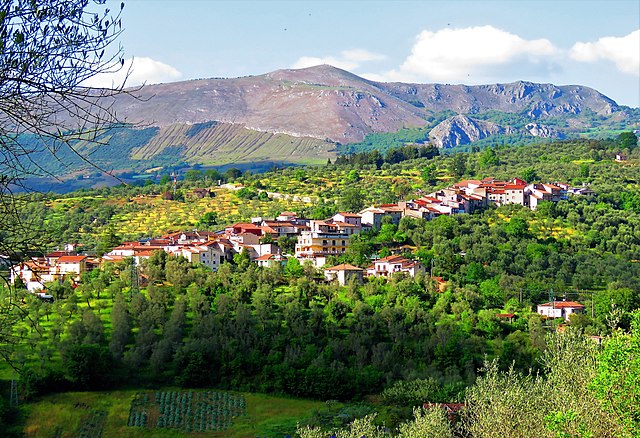
Caggiano
- Italian comune
Hiking in Caggiano
Caggiano is a charming town located in the province of Salerno, in the Campania region of Italy. It’s positioned in the beautiful Apennine Mountains, which provides a stunning backdrop for hiking enthusiasts. Here are some key points about hiking in and around Caggiano:...
- Country:
- Postal Code: 84030
- Local Dialing Code: 0975
- Licence Plate Code: SA
- Coordinates: 40° 34' 0" N, 15° 30' 0" E
- GPS tracks (wikiloc): [Link]
- AboveSeaLevel: 828 м m
- Area: 35.43 sq km
- Population: 2676
- Web site: [Link]


Corleto Monforte
- Italian comune
Hiking in Corleto Monforte
Corleto Monforte is a charming small town located in the region of Basilicata in southern Italy. This area is characterized by its stunning natural beauty, with a mix of rolling hills, rugged mountains, and beautiful landscapes, making it an excellent destination for hiking enthusiasts....
- Country:
- Postal Code: 84020
- Local Dialing Code: 0828
- Licence Plate Code: SA
- Coordinates: 40° 26' 0" N, 15° 23' 0" E
- GPS tracks (wikiloc): [Link]
- AboveSeaLevel: 683 м m
- Area: 58.97 sq km
- Population: 567
- Web site: [Link]

Pertosa
- Italian comune
Hiking in Pertosa
Hiking in Pertosa, a charming village located in the Campania region of southern Italy, offers a variety of scenic trails and opportunities to explore the beautiful natural landscapes. Here are some highlights and tips for your hiking experience in Pertosa:...
- Country:
- Postal Code: 84030
- Local Dialing Code: 0975
- Licence Plate Code: SA
- Coordinates: 40° 33' 0" N, 15° 27' 0" E
- GPS tracks (wikiloc): [Link]
- AboveSeaLevel: 310 м m
- Area: 6.16 sq km
- Population: 683
- Web site: [Link]


Petina, Campania
- Italian comune
Hiking in Petina, Campania
Petina, a charming village in the Campania region of Italy, offers a variety of hiking opportunities that showcase its beautiful natural landscapes and rich history. Here are some highlights for hiking in and around Petina:...
- Country:
- Postal Code: 84020
- Local Dialing Code: 0828
- Licence Plate Code: SA
- Coordinates: 40° 32' 0" N, 15° 22' 0" E
- GPS tracks (wikiloc): [Link]
- AboveSeaLevel: 649 м m
- Area: 35.47 sq km
- Population: 1110
- Web site: [Link]


Polla
- Italian comune
Hiking in Polla
Polla, a charming town located in the Campania region of Italy, is often overlooked by tourists but offers a wealth of natural beauty and hiking opportunities. Nestled in the heart of the Alburni Mountains, it serves as an ideal base for those looking to explore scenic trails, lush landscapes, and authentic Italian culture....
- Country:
- Postal Code: 84035
- Local Dialing Code: 0975
- Licence Plate Code: SA
- Coordinates: 40° 31' 0" N, 15° 30' 0" E
- GPS tracks (wikiloc): [Link]
- AboveSeaLevel: 468 м m
- Area: 48.08 sq km
- Population: 5273
- Web site: [Link]

Salvitelle
- Italian comune
Hiking in Salvitelle
Salvitelle is a picturesque village located in the province of Salerno in the Campania region of Italy, nestled in the Apennine Mountains. Hiking in and around Salvitelle offers a fantastic way to explore the natural beauty, rich history, and charming landscapes of this area....
- Country:
- Postal Code: 84020
- Local Dialing Code: 0975
- Licence Plate Code: SA
- Coordinates: 40° 36' 0" N, 15° 28' 0" E
- GPS tracks (wikiloc): [Link]
- AboveSeaLevel: 630 м m
- Area: 9.6 sq km
- Population: 526
- Web site: [Link]


Sicignano degli Alburni
- Italian comune
Hiking in Sicignano degli Alburni
Sicignano degli Alburni is a charming town located in the Campania region of southern Italy. It’s nestled in the Alburni Mountains, which offer a diverse range of hiking opportunities, rich natural beauty, and stunning landscapes. Here’s an overview of hiking in and around Sicignano degli Alburni:...
- Country:
- Postal Code: 84029
- Local Dialing Code: 0828
- Licence Plate Code: SA
- Coordinates: 40° 33' 35" N, 15° 18' 25" E
- GPS tracks (wikiloc): [Link]
- AboveSeaLevel: 605 м m
- Area: 81.11 sq km
- Population: 3411
- Web site: [Link]