Pont-Canavese (Pont Canavese)
- Italian comune
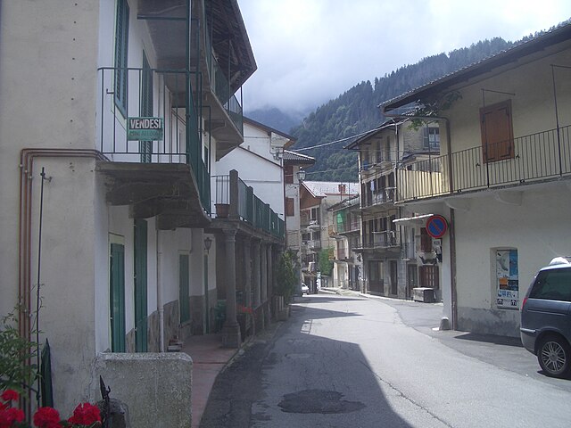
Pont-Canavese is a charming town located in the Canavese region of Northern Italy, nestled in the foothills of the Italian Alps. It offers a variety of hiking opportunities, ranging from easy walks to more challenging trails, making it suitable for hikers of all skill levels. Here are some highlights and tips for hiking in and around Pont-Canavese:
Trails and Nature
-
Monte Guglielmo: This peak offers stunning panoramic views of the surrounding valleys and mountains. The hiking trails vary in difficulty, and the ascent can be done in several hours, making it a moderate challenge.
-
Val di Soana: Located not far from Pont-Canavese, this valley offers beautiful trails surrounded by nature, alpine meadows, and opportunities for wildlife spotting. It’s a great spot for both hiking and photography.
-
Rural Paths: There are numerous paths connecting small villages and hamlets in the area, providing an opportunity for a more leisurely hike to explore local culture and enjoy the picturesque landscapes.
Best Time to Hike
- Spring and Fall: These seasons are ideal for hiking, as the weather is generally mild, and the trails are less crowded.
- Summer: It can get warm, but it's still a great time to hike, especially at higher altitudes where temperatures are cooler.
Tips for Hiking in Pont-Canavese
-
Stay Informed: Always check the local weather conditions before heading out and be aware of trail conditions, as they can change rapidly.
-
Bring Essentials: Pack plenty of water, snacks, a map or GPS device, and a first aid kit. Good hiking boots and walking poles can be helpful, especially on rugged paths.
-
Respect Nature: Stay on marked trails, and follow Leave No Trace principles to minimize your impact on the environment.
-
Local Guides: Consider hiring a local guide for more challenging hikes or if you're unfamiliar with the area. They can provide valuable information about the trails and enhance your experience.
-
Cultural Stops: If time allows, integrate visits to local historical sites or villages along your route to enrich your hiking experience.
Accommodations
Pont-Canavese offers various accommodations, including hotels, guesthouses, and B&Bs. You can also find places that cater specifically to hikers, offering resources and advice on local trails.
Overall, hiking in Pont-Canavese is a wonderful way to explore the natural beauty and cultural heritage of this stunning region in Italy. Happy hiking!
- Country:

- Postal Code: 10085
- Local Dialing Code: 0124
- Licence Plate Code: TO
- Coordinates: 45° 25' 0" N, 7° 36' 0" E


- GPS tracks (wikiloc): [Link]
- AboveSeaLevel: 461 м m
- Area: 19.06 sq km
- Population: 3307
- Web site: http://www.comune.pontcanavese.to.it/
- Wikipedia en: wiki(en)
- Wikipedia: wiki(it)
- Wikidata storage: Wikidata: Q10198
- Wikipedia Commons Gallery: [Link]
- Wikipedia Commons Category: [Link]
- Freebase ID: [/m/0g8kk1]
- GeoNames ID: Alt: [6536030]
- VIAF ID: Alt: [151233846]
- OSM relation ID: [44967]
- TGN ID: [1046084]
- ISTAT ID: 001199
- Italian cadastre code: G826
Shares border with regions:


Ronco Canavese
- Italian comune
Ronco Canavese is a charming village located in the Canavese region of northern Italy, nestled in the foothills of the Alps. The area offers a variety of hiking opportunities with stunning views, rich natural landscapes, and an abundance of cultural heritage....
- Country:

- Postal Code: 10080
- Local Dialing Code: 0124
- Licence Plate Code: TO
- Coordinates: 45° 30' 0" N, 7° 33' 0" E


- GPS tracks (wikiloc): [Link]
- Area: 96.27 sq km
- Population: 308
- Web site: [Link]


Sparone
- Italian comune
Sparone is a charming town located in the Piedmont region of Italy, nestled in the Susa Valley and surrounded by the magnificent scenery of the Italian Alps. It presents a variety of hiking opportunities for outdoor enthusiasts, offering routes that cater to different skill levels....
- Country:

- Postal Code: 10080
- Local Dialing Code: 0124
- Licence Plate Code: TO
- Coordinates: 45° 25' 0" N, 7° 33' 0" E


- GPS tracks (wikiloc): [Link]
- AboveSeaLevel: 552 м m
- Area: 29.68 sq km
- Population: 995
- Web site: [Link]


Alpette
- Italian comune
Alpette, located in the French Alps, is a beautiful destination for hiking enthusiasts. The region offers stunning alpine scenery, diverse trails, and a variety of landscapes ranging from lush valleys to rugged mountain terrain. Here are some key points to consider when hiking in Alpette:...
- Country:

- Postal Code: 10080
- Local Dialing Code: 0124
- Licence Plate Code: TO
- Coordinates: 45° 24' 34" N, 7° 34' 45" E


- GPS tracks (wikiloc): [Link]
- AboveSeaLevel: 957 м m
- Area: 5.63 sq km
- Population: 255
- Web site: [Link]


Chiesanuova
- Italian comune
Chiesanuova is a charming village in the Piedmont region of Italy, nestled in the foothills of the Alps. It offers a range of hiking opportunities that allow you to explore the stunning natural landscapes and enjoy the serene environment....
- Country:

- Postal Code: 10080
- Local Dialing Code: 0124
- Licence Plate Code: TO
- Coordinates: 45° 25' 0" N, 7° 39' 0" E


- GPS tracks (wikiloc): [Link]
- AboveSeaLevel: 664 м m
- Area: 4.12 sq km
- Population: 236
- Web site: [Link]


Cuorgnè
- Italian comune
Cuorgnè, located in the Piedmont region of Italy, is surrounded by stunning landscapes that offer numerous hiking opportunities. Positioned near the foothills of the Alps, the area is known for its diverse terrain, which includes hills, forests, and panoramic viewpoints....
- Country:

- Postal Code: 10082
- Local Dialing Code: 0124
- Licence Plate Code: TO
- Coordinates: 45° 23' 0" N, 7° 39' 0" E


- GPS tracks (wikiloc): [Link]
- AboveSeaLevel: 414 м m
- Area: 19.31 sq km
- Population: 9728
- Web site: [Link]


Frassinetto
- Municipality in Italy
Frassinetto is a charming village located in the Susa Valley of Italy, nestled in the Piedmont region of the Alps. It is a great starting point for outdoor enthusiasts looking to explore the stunning natural beauty of the surrounding area. Here’s some information on hiking in and around Frassinetto:...
- Country:

- Postal Code: 10080
- Local Dialing Code: 0124
- Licence Plate Code: TO
- Coordinates: 45° 26' 18" N, 7° 36' 32" E


- GPS tracks (wikiloc): [Link]
- AboveSeaLevel: 1050 м m
- Area: 24.82 sq km
- Population: 277
- Web site: [Link]


Ingria
- Italian comune
Ingria is a small town in the region of Piedmont, Italy, which is located in the Susa Valley close to the Alps. This picturesque area offers a variety of hiking opportunities, making it a great destination for outdoor enthusiasts. Here are some highlights and tips for hiking in Ingria and its nearby regions:...
- Country:

- Postal Code: 10080
- Local Dialing Code: 0124
- Licence Plate Code: TO
- Coordinates: 45° 28' 0" N, 7° 34' 0" E


- GPS tracks (wikiloc): [Link]
- AboveSeaLevel: 816 м m
- Area: 14.75 sq km
- Population: 46
- Web site: [Link]
