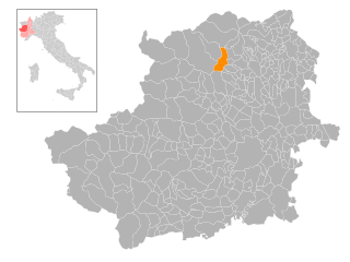
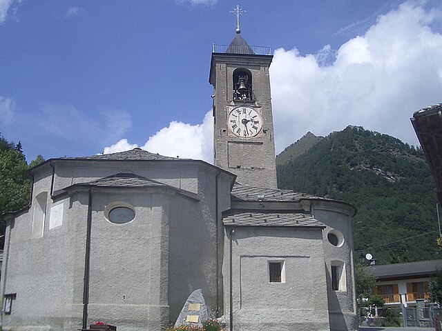
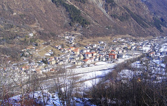
Ronco Canavese (Ronco Canavese)

- Italian comune
 Hiking in Ronco Canavese
Ronco Canavese is a charming village located in the Canavese region of northern Italy, nestled in the foothills of the Alps. The area offers a variety of hiking opportunities with stunning views, rich natural landscapes, and an abundance of cultural heritage.
Hiking Highlights:
-
Trails and Routes: Ronco Canavese features numerous well-marked trails suitable for different skill levels. Some popular hikes include:
- The GRAV (Granito di Rocca): This trail offers a panoramic view of the surrounding mountains and valleys.
- Path of the Krampon: For those seeking a more engaging experience, this trail incorporates sections that may require scrambling.
-
Natural Features: The area is known for its lush forests, wildflower meadows, and striking rock formations. You may encounter a variety of wildlife, including deer, foxes, and numerous bird species.
-
Cultural Sites: Along the hiking routes, you can discover historical sites such as old rural churches, traditional houses, and remnants of ancient agricultural practices.
-
Accessibility: The trails around Ronco Canavese vary in difficulty, making them accessible to both beginners and experienced hikers. It's a good idea to check local maps or guides when planning your hike.
-
Best Time to Hike: The ideal seasons for hiking in this area are late spring to early autumn (May to October) when you can enjoy mild weather and favorable trail conditions.
Preparation Tips:
- Gear: Wear appropriate hiking boots and dress in layers due to varying temperatures. Bring enough water, snacks, and a first-aid kit.
- Maps and Navigation: Carry a physical map or download hiking apps with offline capabilities, as cell service might be limited in remote areas.
- Local Regulations: Respect the natural environment and adhere to local rules regarding wildlife and trail usage.
Getting There:
Ronco Canavese is accessible by car and public transportation from nearby towns and cities. Ensure to check local transport schedules if you plan to hike and return the same day.
Exploring the hiking trails around Ronco Canavese offers not only physical challenges but also the incredible beauty of the Canavese landscape and a peek into its cultural heritage. Enjoy your adventure!
- Country:

- Postal Code: 10080
- Local Dialing Code: 0124
- Licence Plate Code: TO
- Coordinates: 45° 30' 0" N, 7° 33' 0" E


- GPS tracks (wikiloc): [Link]
- Area: 96.27 sq km
- Population: 308
- Web site: http://www.comune.roncobiellese.bi.it
- Wikipedia en: wiki(en)
- Wikipedia: wiki(it)
- Wikidata storage: Wikidata: Q10239
- Wikipedia Commons Category: [Link]
- Freebase ID: [/m/0g8l4y]
- GeoNames ID: Alt: [6540920]
- OSM relation ID: [45064]
- TGN ID: [1046370]
- UN/LOCODE: [IT9RC]
- ISTAT ID: 001224
- Italian cadastre code: H539
Shares border with regions:

Pont-Canavese
- Italian comune
Hiking in Pont-Canavese
Pont-Canavese is a charming town located in the Canavese region of Northern Italy, nestled in the foothills of the Italian Alps. It offers a variety of hiking opportunities, ranging from easy walks to more challenging trails, making it suitable for hikers of all skill levels. Here are some highlights and tips for hiking in and around Pont-Canavese:...
- Country:
- Postal Code: 10085
- Local Dialing Code: 0124
- Licence Plate Code: TO
- Coordinates: 45° 25' 0" N, 7° 36' 0" E
- GPS tracks (wikiloc): [Link]
- AboveSeaLevel: 461 м m
- Area: 19.06 sq km
- Population: 3307
- Web site: [Link]
Ribordone
- Italian comune
Hiking in Ribordone
Ribordone is a small village located in the Susa Valley of the Piedmont region in northern Italy. Nestled in the Alps, it offers beautiful landscapes and a variety of outdoor activities, making it a great destination for hiking enthusiasts....
- Country:
- Postal Code: 10080
- Local Dialing Code: 0124
- Licence Plate Code: TO
- Coordinates: 45° 26' 0" N, 7° 30' 0" E
- GPS tracks (wikiloc): [Link]
- Area: 43.6 sq km
- Population: 49
- Web site: [Link]

Sparone
- Italian comune
Hiking in Sparone
Sparone is a charming town located in the Piedmont region of Italy, nestled in the Susa Valley and surrounded by the magnificent scenery of the Italian Alps. It presents a variety of hiking opportunities for outdoor enthusiasts, offering routes that cater to different skill levels....
- Country:
- Postal Code: 10080
- Local Dialing Code: 0124
- Licence Plate Code: TO
- Coordinates: 45° 25' 0" N, 7° 33' 0" E
- GPS tracks (wikiloc): [Link]
- AboveSeaLevel: 552 м m
- Area: 29.68 sq km
- Population: 995
- Web site: [Link]


Traversella
- Italian comune
Hiking in Traversella
Traversella is a charming village located in the province of Turin, in the Piedmont region of northern Italy. It is nestled in a beautiful valley surrounded by the stunning peaks of the Gran Paradiso National Park, making it a great destination for hiking enthusiasts....
- Country:
- Postal Code: 10080
- Local Dialing Code: 0125
- Licence Plate Code: TO
- Coordinates: 45° 31' 0" N, 7° 45' 0" E
- GPS tracks (wikiloc): [Link]
- AboveSeaLevel: 827 м m
- Area: 39.36 sq km
- Population: 332
- Web site: [Link]

Valprato Soana
- Italian comune
Hiking in Valprato Soana
Valprato Soana is a picturesque valley located in the Piedmont region of northern Italy, surrounded by the stunning backdrop of the Cottian Alps. It's a great destination for hiking enthusiasts, offering a range of trails suitable for various skill levels, from leisurely walks to more challenging hikes....
- Country:
- Postal Code: 10080
- Local Dialing Code: 0124
- Licence Plate Code: TO
- Coordinates: 45° 31' 0" N, 7° 33' 0" E
- GPS tracks (wikiloc): [Link]
- Area: 71.85 sq km
- Population: 101
- Web site: [Link]


Cogne
- town and comune in Italy
Hiking in Cogne
Cogne is a stunning valley located in the Aosta region of northern Italy, surrounded by the majestic Grand Paradiso National Park. It offers a variety of hiking opportunities that cater to different skill levels and preferences, from leisurely walks to challenging treks....
- Country:
- Postal Code: 11012
- Local Dialing Code: 0165
- Licence Plate Code: AO
- Coordinates: 45° 36' 27" N, 7° 21' 29" E
- GPS tracks (wikiloc): [Link]
- AboveSeaLevel: 1534 м m
- Area: 213.04 sq km
- Population: 1370
- Web site: [Link]


Ingria
- Italian comune
Hiking in Ingria
Ingria is a small town in the region of Piedmont, Italy, which is located in the Susa Valley close to the Alps. This picturesque area offers a variety of hiking opportunities, making it a great destination for outdoor enthusiasts. Here are some highlights and tips for hiking in Ingria and its nearby regions:...
- Country:
- Postal Code: 10080
- Local Dialing Code: 0124
- Licence Plate Code: TO
- Coordinates: 45° 28' 0" N, 7° 34' 0" E
- GPS tracks (wikiloc): [Link]
- AboveSeaLevel: 816 м m
- Area: 14.75 sq km
- Population: 46
- Web site: [Link]

Locana
- Italian comune
Hiking in Locana
Locana is a beautiful valley located in the Piedmont region of Italy, nestled within the southern part of the Gran Paradiso National Park. It offers a variety of hiking opportunities for different skill levels, from leisurely strolls to more challenging treks. Here are some highlights and tips for hiking in Locana:...
- Country:
- Postal Code: 10080
- Local Dialing Code: 0124
- Licence Plate Code: TO
- Coordinates: 45° 25' 1" N, 7° 27' 31" E
- GPS tracks (wikiloc): [Link]
- AboveSeaLevel: 613 м m
- Area: 132.52 sq km
- Population: 1450
- Web site: [Link]