Précy-Saint-Martin (Précy-Saint-Martin)

- commune in Aube, France
- Country:

- Postal Code: 10500
- Coordinates: 48° 24' 59" N, 4° 27' 1" E


- GPS tracks (wikiloc): [Link]
- Area: 6.57 sq km
- Population: 190
- Wikipedia en: wiki(en)
- Wikipedia: wiki(fr)
- Wikidata storage: Wikidata: Q1364845
- Wikipedia Commons Category: [Link]
- Freebase ID: [/m/03m8v5f]
- GeoNames ID: Alt: [6426524]
- SIREN number: [211002951]
- BnF ID: [152463965]
- INSEE municipality code: 10304
Shares border with regions:


Lesmont
- commune in Aube, France
- Country:
- Postal Code: 10500
- Coordinates: 48° 25' 39" N, 4° 24' 52" E
- GPS tracks (wikiloc): [Link]
- Area: 9.92 sq km
- Population: 315

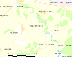
Précy-Notre-Dame
- commune in Aube, France
- Country:
- Postal Code: 10500
- Coordinates: 48° 24' 40" N, 4° 26' 14" E
- GPS tracks (wikiloc): [Link]
- Area: 4.53 sq km
- Population: 84
Saint-Léger-sous-Brienne
- commune in Aube, France
- Country:
- Postal Code: 10500
- Coordinates: 48° 24' 14" N, 4° 30' 11" E
- GPS tracks (wikiloc): [Link]
- Area: 13.52 sq km
- Population: 391
Épagne
- commune in Aube, France
- Country:
- Postal Code: 10500
- Coordinates: 48° 23' 38" N, 4° 27' 54" E
- GPS tracks (wikiloc): [Link]
- Area: 3.94 sq km
- Population: 127


Saint-Christophe-Dodinicourt
- commune in Aube, France
- Country:
- Postal Code: 10500
- Coordinates: 48° 26' 20" N, 4° 28' 12" E
- GPS tracks (wikiloc): [Link]
- Area: 4.87 sq km
- Population: 34