Préneron (Préneron)

- commune in Gers, France
- Country:

- Postal Code: 32190
- Coordinates: 43° 43' 36" N, 0° 16' 37" E


- GPS tracks (wikiloc): [Link]
- Area: 8.63 sq km
- Population: 138
- Wikipedia en: wiki(en)
- Wikipedia: wiki(fr)
- Wikidata storage: Wikidata: Q1004959
- Wikipedia Commons Category: [Link]
- Freebase ID: [/m/03nrs4r]
- GeoNames ID: Alt: [6432069]
- SIREN number: [213203326]
- BnF ID: [152559180]
- INSEE municipality code: 32332
Shares border with regions:
Roquebrune
- commune in Gers, France
- Country:
- Postal Code: 32190
- Coordinates: 43° 43' 14" N, 0° 18' 0" E
- GPS tracks (wikiloc): [Link]
- Area: 18.41 sq km
- Population: 210

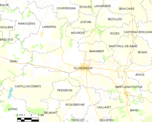
Vic-Fezensac
- commune in Gers, France
- Country:
- Postal Code: 32190
- Coordinates: 43° 45' 30" N, 0° 18' 12" E
- GPS tracks (wikiloc): [Link]
- Area: 53.94 sq km
- Population: 3488
- Web site: [Link]


Belmont
- commune in Gers, France
- Country:
- Postal Code: 32190
- Coordinates: 43° 41' 23" N, 0° 14' 23" E
- GPS tracks (wikiloc): [Link]
- Area: 15.1 sq km
- Population: 151
Castillon-Debats
- commune in Gers, France
- Country:
- Postal Code: 32190
- Coordinates: 43° 43' 45" N, 0° 12' 59" E
- GPS tracks (wikiloc): [Link]
- Area: 35.05 sq km
- Population: 330