Prévenchères (Prévenchères)

- commune in Lozère, France
- Country:

- Postal Code: 48800
- Coordinates: 44° 31' 17" N, 3° 54' 35" E


- GPS tracks (wikiloc): [Link]
- Area: 62.75 sq km
- Population: 257
- Web site: http://www.prevencheres.fr
- Wikipedia en: wiki(en)
- Wikipedia: wiki(fr)
- Wikidata storage: Wikidata: Q382337
- Wikipedia Commons Category: [Link]
- Freebase ID: [/m/02z0ssk]
- Freebase ID: [/m/02z0ssk]
- GeoNames ID: Alt: [6435129]
- GeoNames ID: Alt: [6435129]
- SIREN number: [214801193]
- SIREN number: [214801193]
- BnF ID: [152615242]
- BnF ID: [152615242]
- PACTOLS thesaurus ID: [pcrt68PMeaUlGi]
- PACTOLS thesaurus ID: [pcrt68PMeaUlGi]
- INSEE municipality code: 48119
- INSEE municipality code: 48119
Shares border with regions:

Laval-d'Aurelle
- commune in Ardèche, France
- Country:
- Postal Code: 07590
- Coordinates: 44° 33' 54" N, 3° 57' 38" E
- GPS tracks (wikiloc): [Link]
- Area: 8.72 sq km
- Population: 45

Saint-Laurent-les-Bains
- commune in Ardèche, France
- Country:
- Postal Code: 07590
- Coordinates: 44° 36' 23" N, 3° 58' 11" E
- GPS tracks (wikiloc): [Link]
- Area: 26.76 sq km
- Population: 136
- Web site: [Link]


Pied-de-Borne
- commune in Lozère, France
- Country:
- Postal Code: 48800
- Coordinates: 44° 28' 32" N, 3° 59' 5" E
- GPS tracks (wikiloc): [Link]
- AboveSeaLevel: 450 м m
- Area: 27.89 sq km
- Population: 201

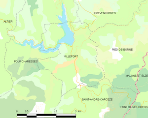
Villefort
- commune in Lozère, France
- Country:
- Postal Code: 48800
- Coordinates: 44° 26' 22" N, 3° 55' 55" E
- GPS tracks (wikiloc): [Link]
- Area: 7.35 sq km
- Population: 568
- Web site: [Link]


Pourcharesses
- commune in Lozère, France
- Country:
- Postal Code: 48800
- Coordinates: 44° 26' 19" N, 3° 55' 58" E
- GPS tracks (wikiloc): [Link]
- AboveSeaLevel: 600 м m
- Area: 31.79 sq km
- Population: 116

Montselgues
- commune in Ardèche, France
- Country:
- Postal Code: 07140
- Coordinates: 44° 31' 24" N, 4° 0' 18" E
- GPS tracks (wikiloc): [Link]
- Area: 35.87 sq km
- Population: 87


La Bastide-Puylaurent
- commune in Lozère, France
- Country:
- Postal Code: 48250
- Coordinates: 44° 35' 33" N, 3° 54' 19" E
- GPS tracks (wikiloc): [Link]
- Area: 24.19 sq km
- Population: 164


Altier
- commune in Lozère, France
- Country:
- Postal Code: 48800
- Coordinates: 44° 28' 27" N, 3° 51' 41" E
- GPS tracks (wikiloc): [Link]
- Area: 54.45 sq km
- Population: 208


Chasseradès
- former commune in Lozère, France
- Country:
- Postal Code: 48250
- Coordinates: 44° 33' 4" N, 3° 49' 33" E
- GPS tracks (wikiloc): [Link]
- Area: 61.93 sq km
- Population: 143