Pruzilly (Pruzilly)

- commune in Saône-et-Loire, France
- Country:

- Postal Code: 71570
- Coordinates: 46° 15' 32" N, 4° 41' 52" E


- GPS tracks (wikiloc): [Link]
- Area: 4.29 sq km
- Population: 315
- Web site: http://www.pruzilly.fr
- Wikipedia en: wiki(en)
- Wikipedia: wiki(fr)
- Wikidata storage: Wikidata: Q1626177
- Wikipedia Commons Category: [Link]
- Wikipedia Commons Maps Category: [Link]
- Freebase ID: [/m/03qglsx]
- Freebase ID: [/m/03qglsx]
- GeoNames ID: Alt: [6442370]
- GeoNames ID: Alt: [6442370]
- SIREN number: [217103621]
- SIREN number: [217103621]
- BnF ID: [152733335]
- BnF ID: [152733335]
- INSEE municipality code: 71362
- INSEE municipality code: 71362
Shares border with regions:

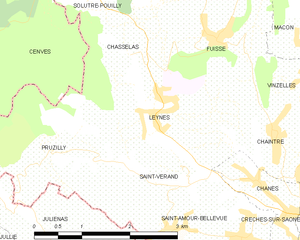
Leynes
- commune in Saône-et-Loire, France
- Country:
- Postal Code: 71570
- Coordinates: 46° 16' 8" N, 4° 43' 42" E
- GPS tracks (wikiloc): [Link]
- Area: 4.83 sq km
- Population: 530
- Web site: [Link]


Saint-Amour-Bellevue
- commune in Saône-et-Loire, France
- Country:
- Postal Code: 71570
- Coordinates: 46° 14' 42" N, 4° 44' 36" E
- GPS tracks (wikiloc): [Link]
- Area: 5.09 sq km
- Population: 539
- Web site: [Link]


Saint-Vérand
- commune in Saône-et-Loire, France
- Country:
- Postal Code: 71570
- Coordinates: 46° 15' 16" N, 4° 44' 8" E
- GPS tracks (wikiloc): [Link]
- AboveSeaLevel: 350 м m
- Area: 2.45 sq km
- Population: 171

Cenves
- commune in Rhône, France
- Country:
- Postal Code: 69840
- Coordinates: 46° 16' 5" N, 4° 38' 59" E
- GPS tracks (wikiloc): [Link]
- Area: 26.48 sq km
- Population: 407
- Web site: [Link]


Juliénas
- commune in Rhône, France
- Country:
- Postal Code: 69840
- Coordinates: 46° 14' 6" N, 4° 42' 41" E
- GPS tracks (wikiloc): [Link]
- Area: 7.56 sq km
- Population: 895
- Web site: [Link]