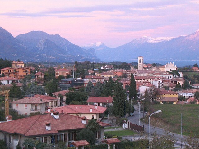
Puegnago sul Garda (Puegnago del Garda)
.svg)
- Italian comune
 Hiking in Puegnago sul Garda
Puegnago sul Garda, located in the Lombardy region of Italy, is a charming village situated near the western shore of Lake Garda. It offers beautiful landscapes, rich flora and fauna, and a variety of hiking opportunities suited for different skill levels.
Hiking Trails and Routes
-
Rocca di Manerba Nature Reserve: Although not directly in Puegnago, it is nearby and offers stunning views of Lake Garda. There are several trails that lead up to the rock formations, where hikers can enjoy panoramic vistas of the lake and surrounding mountains.
-
Sentiero del Vino: This trail is ideal for those looking to combine hiking with local culture. It passes through vineyards and olive groves, allowing hikers to appreciate the local agricultural landscape and sample regional wines.
-
Monte Pizzoccolo: This mountain offers a more challenging hike. The trails lead through diverse terrains and provide breathtaking views at the summit. It’s a suitable option for more experienced hikers.
-
Lake Garda Trails: Numerous scenic paths meander along the lakeshore, providing a flatter terrain for leisurely walks with amazing views. These trails are perfect for families and those who prefer a gentle hike.
Suitable Times for Hiking
The best times to hike in Puegnago sul Garda are during spring (April to June) and autumn (September to October) when the weather is mild, and the landscapes are particularly beautiful with blooming flora or autumn colors. Summer can be quite hot, making early morning or late afternoon hikes more comfortable.
Tips for Hikers
- Footwear: Choose sturdy hiking shoes with good grip.
- Water and Snacks: Always carry enough water and some energy-boosting snacks.
- Sun Protection: Sunscreen and a hat are essential, especially during the summer months.
- Map or GPS: While trails are generally marked, it's good to have a map or a GPS device to navigate.
- Respect Nature: Stick to marked trails and take your litter with you.
Puegnago sul Garda, with its stunning natural beauty and tranquil environment, is an excellent destination for hiking enthusiasts looking to explore the area around Lake Garda. Enjoy your hiking adventure!
- Country:

- Postal Code: 25080
- Local Dialing Code: 0365
- Licence Plate Code: BS
- Coordinates: 45° 34' 0" N, 10° 30' 36" E


- GPS tracks (wikiloc): [Link]
- AboveSeaLevel: 224 м m
- Area: 10.97 sq km
- Population: 3444
- Web site: http://www.comune.puegnagodelgarda.bs.it/
- Wikipedia en: wiki(en)
- Wikipedia: wiki(it)
- Wikidata storage: Wikidata: Q111550
- Wikipedia Commons Category: [Link]
- Freebase ID: [/m/047drh]
- GeoNames ID: Alt: [6542778]
- VIAF ID: Alt: [248771084]
- OSM relation ID: [45351]
- UN/LOCODE: [ITPUE]
- ISTAT ID: 017158
- Italian cadastre code: H086
Shares border with regions:

Gavardo
- Italian comune
Hiking in Gavardo
Gavardo, located in the Lombardy region of Italy, offers a range of hiking opportunities amidst its beautiful natural landscapes. The area is characterized by rolling hills, picturesque vineyards, and nearby access to the larger mountain ranges such as the Alps and the Prealps....
- Country:
- Postal Code: 25085
- Local Dialing Code: 0365
- Licence Plate Code: BS
- Coordinates: 45° 35' 15" N, 10° 26' 20" E
- GPS tracks (wikiloc): [Link]
- AboveSeaLevel: 199 м m
- Area: 29.8 sq km
- Population: 12197
- Web site: [Link]

Manerba del Garda
- Italian comune
Hiking in Manerba del Garda
Manerba del Garda is a beautiful area located on the western shore of Lake Garda in northern Italy. The region is known for its stunning natural scenery, rich history, and a variety of hiking paths that cater to different skill levels. Here are some key highlights and tips for hiking in Manerba del Garda:...
- Country:
- Postal Code: 25080
- Local Dialing Code: 0365
- Licence Plate Code: BS
- Coordinates: 45° 32' 59" N, 10° 33' 5" E
- GPS tracks (wikiloc): [Link]
- AboveSeaLevel: 130 м m
- Area: 36.63 sq km
- Population: 5357
- Web site: [Link]
Muscoline
- Italian comune
Hiking in Muscoline
Muscoline, located in Northern Italy, is a delightful destination for hiking enthusiasts who appreciate natural beauty and stunning landscapes. The region is characterized by rolling hills, lush forests, and scenic views of the surrounding countryside....
- Country:
- Postal Code: 25080
- Local Dialing Code: 0365
- Licence Plate Code: BS
- Coordinates: 45° 34' 0" N, 10° 28' 0" E
- GPS tracks (wikiloc): [Link]
- AboveSeaLevel: 272 м m
- Area: 10.08 sq km
- Population: 2654
- Web site: [Link]
Polpenazze del Garda
- Italian comune
Hiking in Polpenazze del Garda
Polpenazze del Garda, located in the province of Brescia in northern Italy, offers a charming hiking experience with stunning views of Lake Garda and the surrounding countryside. This quaint town is part of the Valtènesi area, known for its vineyards, olive groves, and hilly landscapes, making it a perfect destination for both novice and experienced hikers....
- Country:
- Postal Code: 25080
- Local Dialing Code: 0365
- Licence Plate Code: BS
- Coordinates: 45° 32' 41" N, 10° 30' 51" E
- GPS tracks (wikiloc): [Link]
- AboveSeaLevel: 204 м m
- Area: 9.12 sq km
- Population: 2672
- Web site: [Link]

Salò
- Italian comune
Hiking in Salò
Salò, located on the western shore of Lake Garda in Italy, offers stunning landscapes and a variety of hiking trails for all levels of experience. Here’s an overview of what you can expect when hiking in the Salò area:...
- Country:
- Postal Code: 25087
- Local Dialing Code: 0365
- Licence Plate Code: BS
- Coordinates: 45° 36' 0" N, 10° 32' 0" E
- GPS tracks (wikiloc): [Link]
- AboveSeaLevel: 65 м m
- Area: 29.75 sq km
- Population: 10603
- Web site: [Link]

San Felice del Benaco
- Italian comune
Hiking in San Felice del Benaco
San Felice del Benaco is a picturesque town located on the western shores of Lake Garda in Italy. It offers a variety of hiking opportunities that are suitable for different skill levels, and the scenery is often breathtaking, with views of the lake, mountains, and lush landscapes....
- Country:
- Postal Code: 25010
- Local Dialing Code: 0365
- Licence Plate Code: BS
- Coordinates: 45° 35' 0" N, 10° 33' 0" E
- GPS tracks (wikiloc): [Link]
- AboveSeaLevel: 109 м m
- Area: 20.22 sq km
- Population: 3395
- Web site: [Link]