Queige (Queige)
- commune in Savoie, France
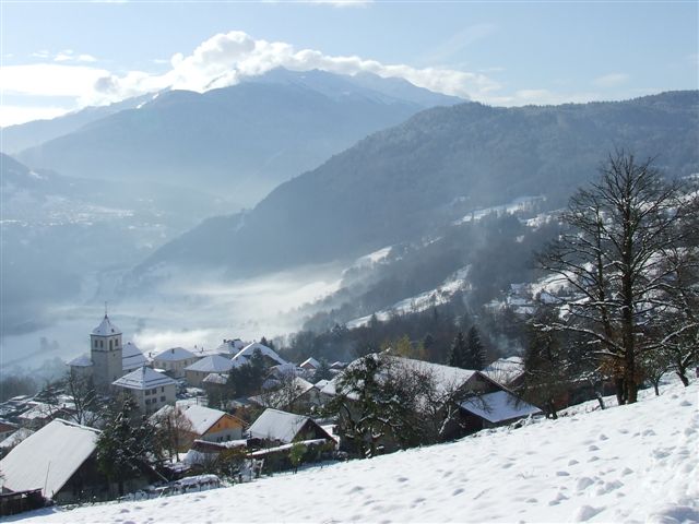
Queige is a picturesque village located in the French Alps, close to the Beaufortain massif. It offers beautiful landscapes, charming scenery, and a variety of hiking opportunities suitable for different skill levels.
Hiking Trails
-
Les Sentiers de Balcon: This trail offers stunning panoramic views of the surrounding mountains and valleys. It’s relatively easy, making it great for families or those looking for a leisurely hike.
-
Col de la Forclaz: For those looking for a moderate challenge, this trail takes you to a high mountain pass with breathtaking views and a chance to see local wildlife.
-
Beaufortain Nature Reserve: You can explore various trails within the beauty of the nature reserve, with options for both short walks and longer hikes. The area is known for its rich biodiversity.
-
Trekking to Beaufort: This hike allows you to discover the village of Beaufort, famous for its cheese. The trail is scenic and provides cultural insights along the way.
Tips for Hiking in Queige
- Season: Late spring to early autumn is the best time for hiking. Make sure to check trail conditions, especially if hiking in early or late season when snow may still be present.
- Equipment: Wear sturdy hiking shoes, and consider bringing trekking poles for added stability on uneven terrain. Don't forget water, snacks, and a map or GPS.
- Weather: The weather can change rapidly in the mountains. Dress in layers and be prepared for different conditions.
- Safety: Always let someone know your hiking plans, especially if you're heading into less populated areas.
Local Attractions
- Gastronomy: Make time to enjoy local cuisine, particularly the famous Beaufort cheese.
- Cultural Sites: Explore the nearby historical sites, such as churches and traditional architecture in the village.
Hiking in Queige provides a wonderful opportunity to immerse yourself in the natural beauty of the Alps while enjoying the local culture. Whether you're a beginner or an experienced hiker, there's something for everyone in this charming alpine region.
- Country:

- Postal Code: 73720
- Coordinates: 45° 43' 11" N, 6° 27' 33" E


- GPS tracks (wikiloc): [Link]
- Area: 32.61 sq km
- Population: 825
- Web site: http://www.queige.fr
- Wikipedia en: wiki(en)
- Wikipedia: wiki(fr)
- Wikidata storage: Wikidata: Q1214448
- Wikipedia Commons Category: [Link]
- Freebase ID: [/m/03npf7f]
- GeoNames ID: Alt: [6442854]
- SIREN number: [217302116]
- BnF ID: [15274142t]
- INSEE municipality code: 73211
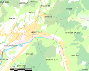
Shares border with regions:


Beaufort
- commune in Savoie, France
Beaufort, located in the Savoie region of the French Alps, offers a stunning backdrop for hiking enthusiasts. Known for its picturesque alpine landscapes, the area is characterized by rolling hills, lush meadows, and rugged mountain terrain. Here are some highlights and tips for hiking in Beaufort:...
- Country:

- Postal Code: 73270
- Coordinates: 45° 43' 5" N, 6° 34' 30" E


- GPS tracks (wikiloc): [Link]
- Area: 149.53 sq km
- Population: 2088
Tours-en-Savoie
- commune in Savoie, France
Tours-en-Savoie is a picturesque commune located in the Savoie department in the Auvergne-Rhône-Alpes region of southeastern France. It serves as a gateway to several hiking opportunities in the stunning landscapes of the French Alps. Here are some key points and recommendations for hiking in and around Tours-en-Savoie:...
- Country:

- Postal Code: 73790
- Coordinates: 45° 39' 19" N, 6° 26' 24" E


- GPS tracks (wikiloc): [Link]
- Area: 15.37 sq km
- Population: 949
Villard-sur-Doron
- commune in Savoie, France
Villard-sur-Doron is a charming village located in the Savoie region of the French Alps, providing a great base for hiking enthusiasts. Nestled in a picturesque valley, it serves as an excellent spot for exploring the natural beauty of the surrounding mountains....
- Country:

- Postal Code: 73270
- Coordinates: 45° 43' 36" N, 6° 31' 42" E


- GPS tracks (wikiloc): [Link]
- Area: 22.21 sq km
- Population: 698
- Web site: [Link]
Venthon
- commune in Savoie, France
Venthon is a beautiful destination for hiking enthusiasts, located in the Savoie region of the French Alps. The area offers a variety of hiking trails that cater to different skill levels, ranging from gentle walks to more challenging hikes....
- Country:

- Postal Code: 73200
- Coordinates: 45° 41' 16" N, 6° 24' 49" E


- GPS tracks (wikiloc): [Link]
- Area: 2.5 sq km
- Population: 635


Marthod
- commune in Savoie, France
Marthod is a charming village located in the Savoie region of France, nestled in the Alps. It is a great base for hiking enthusiasts looking to explore the stunning mountainous terrain and enjoy breathtaking views of the surrounding landscapes. Here are some key points to consider when hiking in Marthod:...
- Country:

- Postal Code: 73400
- Coordinates: 45° 43' 33" N, 6° 24' 13" E


- GPS tracks (wikiloc): [Link]
- Area: 14.78 sq km
- Population: 1382


Albertville
- commune in Savoie, France
Albertville, located in the Savoie region of the French Alps, offers a variety of hiking opportunities for outdoor enthusiasts. The area is surrounded by stunning mountain landscapes, including the Belledonne and Chartreuse ranges, making it a fantastic destination for hiking....
- Country:

- Postal Code: 73200
- Coordinates: 45° 40' 33" N, 6° 23' 33" E


- GPS tracks (wikiloc): [Link]
- AboveSeaLevel: 340 м m
- Area: 17.54 sq km
- Population: 18969
- Web site: [Link]
Césarches
- commune in Savoie, France
Césarches is a lesser-known area for hiking, but it can offer beautiful views and a peaceful experience in nature, particularly if you're looking for a more secluded adventure. While detailed information might be sparse, the region generally features scenic landscapes, including forests, valleys, and streams....
- Country:

- Postal Code: 73200
- Coordinates: 45° 42' 4" N, 6° 24' 43" E


- GPS tracks (wikiloc): [Link]
- Area: 2.9 sq km
- Population: 425


Ugine
- commune in Savoie, France
Ugine is a charming small town located in the Savoie department of the Auvergne-Rhône-Alpes region in France. Nestled between the mountains and near Lake Annecy, it offers a variety of hiking opportunities that cater to different skill levels and preferences. Here’s a guide to hiking in and around Ugine:...
- Country:

- Postal Code: 73400
- Coordinates: 45° 45' 10" N, 6° 25' 11" E


- GPS tracks (wikiloc): [Link]
- Area: 57.36 sq km
- Population: 7042
- Web site: [Link]

