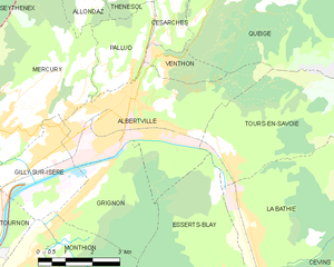
Tours-en-Savoie (Tours-en-Savoie)

- commune in Savoie, France
 Hiking in Tours-en-Savoie
Tours-en-Savoie is a picturesque commune located in the Savoie department in the Auvergne-Rhône-Alpes region of southeastern France. It serves as a gateway to several hiking opportunities in the stunning landscapes of the French Alps. Here are some key points and recommendations for hiking in and around Tours-en-Savoie:
Trails and Landscapes:
-
Scenic Views: The area is characterized by breathtaking mountain views, lush valleys, and beautiful lakes. Hiking trails often offer panoramic vistas of the surrounding peaks, which can be especially stunning during sunrise or sunset.
-
Varied Difficulty Levels: The trails around Tours-en-Savoie cater to hikers of all skill levels, from easy walks suitable for families to more challenging treks for experienced hikers. Look for local maps or information boards that indicate trail difficulty.
-
Nature and Wildlife: Hikers can experience a variety of flora and fauna, especially in the spring and summer months when wildflowers bloom and wildlife is more active. Keep an eye out for local species!
Popular Hiking Areas Nearby:
-
Chartreuse Mountains: To the east of Tours-en-Savoie, this range offers numerous trails with varying difficulty. The views of the surrounding countryside are magnificent, and the area is well-marked for hikers.
-
Belledonne Range: To the south, the Belledonne mountains are known for their rugged landscapes and challenging trails, perfect for those seeking a more adventurous hike.
-
Lac du Bourget: A short drive from Tours-en-Savoie, this beautiful lake is surrounded by several trails and offers opportunities for scenic hikes along its shores.
Practical Considerations:
-
Best Seasons: The best times to hike in the region are generally from late spring to early autumn (May to October). During this period, the weather is usually mild and good for outdoor activities.
-
Equipment: Ensure you have appropriate hiking gear, including sturdy boots, weather-appropriate clothing, and a reliable map or GPS device. Hydration and snacks are also essential for longer hikes.
-
Local Resources: Check in with local tourism offices for maps and trail recommendations. They often have the latest information on trail conditions and nearby attractions.
Safety Tips:
- Always inform someone about your hiking plans before you head out.
- Be aware of changing weather conditions, as mountain weather can be unpredictable.
- Follow the Leave No Trace principles to preserve the natural beauty of the area.
Hiking around Tours-en-Savoie can offer a blend of natural beauty, physical challenge, and cultural experiences, making it a worthwhile destination for outdoor enthusiasts. Enjoy your hiking adventure!
- Country:

- Postal Code: 73790
- Coordinates: 45° 39' 19" N, 6° 26' 24" E


- GPS tracks (wikiloc): [Link]
- Area: 15.37 sq km
- Population: 949
- Wikipedia en: wiki(en)
- Wikipedia: wiki(fr)
- Wikidata storage: Wikidata: Q1214383
- Wikipedia Commons Category: [Link]
- Freebase ID: [/m/03npgxw]
- GeoNames ID: Alt: [6442913]
- SIREN number: [217302983]
- BnF ID: [15274228j]
- INSEE municipality code: 73298
Shares border with regions:


Beaufort
- commune in Savoie, France
Hiking in Beaufort
Beaufort, located in the Savoie region of the French Alps, offers a stunning backdrop for hiking enthusiasts. Known for its picturesque alpine landscapes, the area is characterized by rolling hills, lush meadows, and rugged mountain terrain. Here are some highlights and tips for hiking in Beaufort:...
- Country:
- Postal Code: 73270
- Coordinates: 45° 43' 5" N, 6° 34' 30" E
- GPS tracks (wikiloc): [Link]
- Area: 149.53 sq km
- Population: 2088


Queige
- commune in Savoie, France
Hiking in Queige
Queige is a picturesque village located in the French Alps, close to the Beaufortain massif. It offers beautiful landscapes, charming scenery, and a variety of hiking opportunities suitable for different skill levels....
- Country:
- Postal Code: 73720
- Coordinates: 45° 43' 11" N, 6° 27' 33" E
- GPS tracks (wikiloc): [Link]
- Area: 32.61 sq km
- Population: 825
- Web site: [Link]

Albertville
- commune in Savoie, France
Hiking in Albertville
Albertville, located in the Savoie region of the French Alps, offers a variety of hiking opportunities for outdoor enthusiasts. The area is surrounded by stunning mountain landscapes, including the Belledonne and Chartreuse ranges, making it a fantastic destination for hiking....
- Country:
- Postal Code: 73200
- Coordinates: 45° 40' 33" N, 6° 23' 33" E
- GPS tracks (wikiloc): [Link]
- AboveSeaLevel: 340 м m
- Area: 17.54 sq km
- Population: 18969
- Web site: [Link]


La Bâthie
- commune in Savoie, France
Hiking in La Bâthie
La Bâthie is a charming area located in the Savoie region of France, nestled in the heart of the French Alps. It offers a variety of hiking opportunities suitable for various skill levels, making it a great destination for outdoor enthusiasts....
- Country:
- Postal Code: 73540
- Coordinates: 45° 37' 37" N, 6° 26' 58" E
- GPS tracks (wikiloc): [Link]
- Area: 22.45 sq km
- Population: 2184


Esserts-Blay
- commune in Savoie, France
Hiking in Esserts-Blay
Esserts-Blay is a charming destination in Switzerland that offers a variety of hiking opportunities amidst breathtaking landscapes. Nestled in the Jura Mountains, it is known for its scenic trails that cater to different skill levels, from leisurely walks to more challenging treks....
- Country:
- Postal Code: 73540
- Coordinates: 45° 36' 47" N, 6° 26' 9" E
- GPS tracks (wikiloc): [Link]
- Area: 15.51 sq km
- Population: 806