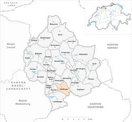
Rünenberg (Rünenberg)

- municipality in Switzerland
 Hiking in Rünenberg
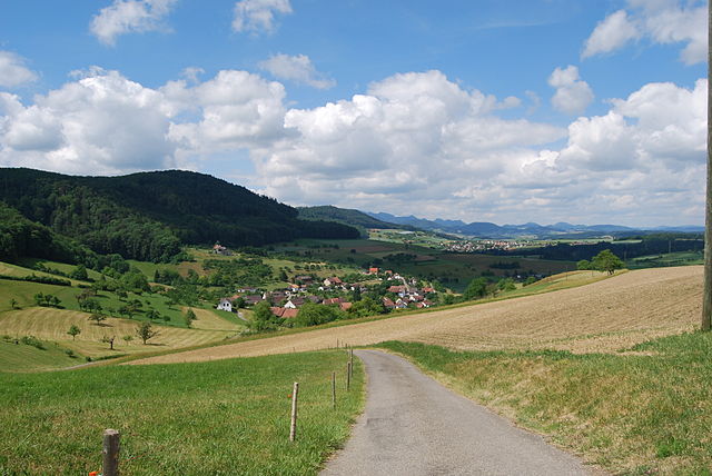
Rünenberg, located in the canton of Baselland in Switzerland, is an excellent area for hiking enthusiasts. The region offers picturesque landscapes, charming farms, and views of the rolling hills typical of the Swiss countryside. Here are some highlights to consider when hiking in Rünenberg:
Trails
-
Variety of Trails: Rünenberg features a network of well-marked trails suitable for different skill levels. You can find easy walks as well as more challenging hikes.
-
Educational Trails: Some trails are designed as educational paths, providing information about local flora and fauna, as well as the region's cultural heritage.
-
Connecting Routes: Rünenberg is connected to larger hiking networks, making it easy to extend your hike to surrounding areas, including nearby villages and other natural attractions.
Scenic Views
- Panoramic Vistas: Many trails in Rünenberg offer stunning views of the Baselland region, with its rolling hills and quaint villages.
- Nature Observation: The area is rich in biodiversity and offers great opportunities for birdwatching and observing local wildlife.
Practical Tips
- Weather: Always check the weather forecast before heading out, as conditions can change quickly in mountainous regions.
- Footwear: Wear sturdy hiking shoes for comfort and traction on varied terrain.
- Hydration and Snacks: Carry enough water and some snacks, as there may be limited access to stores along the trails.
Local Amenities
- Public Transport: Rünenberg is accessible by public transport, making it easy to reach different trailheads.
- Accommodation & Dining: If you plan to hike for multiple days, look for local accommodations and dining options that offer traditional Swiss cuisine.
Safety Considerations
- Trail Conditions: Check for trail conditions and closures, especially after heavy rainfall or snowfall.
- Navigation: Make sure to have a map or GPS device, as not all trails may be well-marked.
Hiking in Rünenberg offers a wonderful opportunity to experience the beauty of the Swiss countryside, making it a rewarding destination for both new and experienced hikers. Enjoy your hike!
- Country:

- Postal Code: 4497
- Local Dialing Code: 061
- Licence Plate Code: BL
- Coordinates: 47° 25' 55" N, 7° 52' 49" E


- GPS tracks (wikiloc): [Link]
- AboveSeaLevel: 585 м m
- Area: 4.98 sq km
- Population: 777
- Web site: http://www.ruenenberg.ch
- Wikipedia en: wiki(en)
- Wikipedia: wiki(de)
- Wikidata storage: Wikidata: Q67275
- Wikipedia Commons Category: [Link]
- Freebase ID: [/m/0g81y7]
- GeoNames ID: Alt: [7286986]
- VIAF ID: Alt: [233874550]
- OSM relation ID: [1683702]
- HDS ID: [1236]
- Swiss municipality code: [2860]
Shares border with regions:
Häfelfingen
- municipality in Switzerland
Hiking in Häfelfingen
Häfelfingen is a charming village located in the Basel-Landschaft region of Switzerland, offering beautiful landscapes and opportunities for hiking enthusiasts. The area is characterized by its rolling hills, picturesque vineyards, and stunning views of the surrounding Swiss countryside. Here are some key points about hiking in and around Häfelfingen:...
- Country:
- Postal Code: 4445
- Local Dialing Code: 062
- Licence Plate Code: BL
- Coordinates: 47° 24' 47" N, 7° 52' 13" E
- GPS tracks (wikiloc): [Link]
- AboveSeaLevel: 599 м m
- Area: 3.96 sq km
- Population: 271
- Web site: [Link]


Zeglingen
- municipality in Switzerland
Hiking in Zeglingen
Zeglingen is a picturesque village located in the municipality of Sissach in Switzerland, surrounded by stunning natural landscapes, making it a great spot for hiking enthusiasts. Here are some key highlights about hiking in the Zeglingen area:...
- Country:
- Postal Code: 4495
- Local Dialing Code: 061
- Licence Plate Code: BL
- Coordinates: 47° 24' 44" N, 7° 54' 44" E
- GPS tracks (wikiloc): [Link]
- AboveSeaLevel: 596 м m
- Area: 7.91 sq km
- Population: 489
- Web site: [Link]

Gelterkinden
- municipality in Switzerland
Hiking in Gelterkinden
Gelterkinden, located in the canton of Basel-Landschaft in Switzerland, is an excellent destination for hiking enthusiasts. The region is characterized by picturesque landscapes, diverse terrain, and a mix of forests, hills, and meadows. Here are some key points to consider when hiking in Gelterkinden:...
- Country:
- Postal Code: 4460
- Local Dialing Code: 061
- Licence Plate Code: BL
- Coordinates: 47° 27' 55" N, 7° 51' 10" E
- GPS tracks (wikiloc): [Link]
- AboveSeaLevel: 458 м m
- Area: 9.79 sq km
- Population: 6095
- Web site: [Link]


Kilchberg
- municipality in the canton Basel-Landschaft, Switzerland
Hiking in Kilchberg
Kilchberg, located in the Basel-Landschaft canton of Switzerland, offers a scenic and enjoyable hiking experience. Nestled near the borders of both Basel and the picturesque Jura Mountains, it provides access to varied landscapes, including rolling hills, forests, and stunning views of the surrounding countryside....
- Country:
- Postal Code: 4496
- Local Dialing Code: 061
- Licence Plate Code: BL
- Coordinates: 47° 25' 32" N, 7° 53' 55" E
- GPS tracks (wikiloc): [Link]
- AboveSeaLevel: 588 м m
- Area: 1.59 sq km
- Population: 161
- Web site: [Link]
Tecknau
- municipality in Switzerland
Hiking in Tecknau
Tecknau is a picturesque village located in the Baselland region of Switzerland, surrounded by beautiful landscapes and scenic trails perfect for hiking enthusiasts. Here are some highlights for a hiking experience in and around Tecknau:...
- Country:
- Postal Code: 4492
- Local Dialing Code: 061
- Licence Plate Code: BL
- Coordinates: 47° 26' 43" N, 7° 53' 23" E
- GPS tracks (wikiloc): [Link]
- AboveSeaLevel: 455 м m
- Area: 2.35 sq km
- Population: 858
- Web site: [Link]


Rümlingen
- municipality in Switzerland
Hiking in Rümlingen
Rümlingen is a small village in Switzerland known for its picturesque landscapes and access to nature, making it a great spot for hiking enthusiasts. The region is characterized by rolling hills, lush meadows, and peaceful forests, providing a variety of trails suitable for different skill levels....
- Country:
- Postal Code: 4444
- Local Dialing Code: 062
- Licence Plate Code: BL
- Coordinates: 47° 25' 31" N, 7° 50' 59" E
- GPS tracks (wikiloc): [Link]
- AboveSeaLevel: 459 м m
- Area: 2.28 sq km
- Population: 390
- Web site: [Link]