Rabbi, Trentino (Rabbi)
%202018.svg)
- Italian comune
 Hiking in Rabbi, Trentino
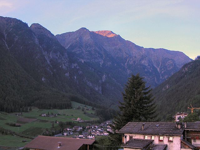
Rabbi, located in the Trentino region of northern Italy, is a picturesque valley known for its natural beauty and excellent hiking opportunities. Nestled in the Val di Rabbi, which is part of the larger Stelvio National Park, it offers a range of trails suitable for various skill levels, from easy walks to more challenging hikes.
Highlights of Hiking in Rabbi:
-
Scenic Landscapes: The area is characterized by stunning alpine scenery, including lush meadows, forests, and rugged mountain peaks. The impressive backdrop of the Ortles-Cevedale mountain range provides a breathtaking setting.
-
Wildlife: While hiking, you may encounter an array of wildlife, including deer, chamois, and various bird species. The rich biodiversity adds an element of excitement to your hiking experience.
-
Cultural Heritage: As you hike through the region, you can discover charming villages, traditional Alpine architecture, and historical sites that are rich in local culture and traditions.
-
Trail Options:
- Easy Trails: For novices or families, there are easier routes that provide stunning views without too much elevation gain. Trails along the valley floor offer leisurely strolls through beautiful landscapes.
- Moderate Trails: For those looking for a bit more adventure, moderate trails lead to higher altitudes, with opportunities to explore waterfalls, alpine lakes, and panoramic viewpoints.
- Challenging Routes: Experienced hikers can tackle more strenuous routes that take you into the heart of the mountains, offering challenging ascents and rewarding vistas.
-
Starting Points: The main village of Rabbi offers various access points to different trails, with clear signage and information available.
-
Natural Attractions: Don’t miss the beautiful waterfalls, such as the Saent Waterfalls, which are easily accessible from some trails. Additionally, the serene lakes in the area, like Lago di Rabbi, are great spots for rest and picnics.
-
Seasonality: Hiking in Rabbi can be enjoyed in the summer months, typically from late May to October, when the trails are generally clear of snow. Autumn also brings stunning colors to the landscape.
-
Equipment: Proper hiking boots, weather-appropriate clothing, and a good backpack with water and snacks are recommended for all hikes.
Local Tips:
- Guided Tours: If you’re unfamiliar with the area or want to learn more about the local flora and fauna, consider joining a guided hiking tour.
- Weather: Always check the weather before heading out, as conditions can change rapidly in the mountains.
- Respect Nature: Follow Leave No Trace principles to preserve the natural beauty of the trails and parks.
Conclusion:
Hiking in Rabbi, Trentino, offers a wonderful opportunity to connect with nature in a tranquil setting. Whether you are a casual walker or an experienced hiker, you'll find trails that suit your preferences while enjoying the spectacular scenery and rich cultural heritage of this enchanting region.
- Country:

- Postal Code: 38020
- Local Dialing Code: 0463
- Licence Plate Code: TN
- Coordinates: 46° 24' 0" N, 10° 51' 0" E


- GPS tracks (wikiloc): [Link]
- AboveSeaLevel: 1095 м m
- Area: 132.79 sq km
- Population: 1363
- Web site: http://www.comune.rabbi.tn.it/
- Wikipedia en: wiki(en)
- Wikipedia: wiki(it)
- Wikidata storage: Wikidata: Q300313
- Wikipedia Commons Category: [Link]
- Freebase ID: [/m/0gb019]
- GeoNames ID: Alt: [6542015]
- VIAF ID: Alt: [305176570]
- OSM relation ID: [47143]
- GND ID: Alt: [1041530692]
- ISTAT ID: 022150
- Italian cadastre code: H146
Shares border with regions:


Pellizzano
- Italian comune
Hiking in Pellizzano
Pellizzano is a charming village located in the Trentino region of northern Italy, nestled in the Val di Sole. It's an excellent base for hiking enthusiasts, offering a variety of trails that cater to different skills and preferences. Here are some highlights of hiking in and around Pellizzano:...
- Country:
- Postal Code: 38020
- Local Dialing Code: 0463
- Licence Plate Code: TN
- Coordinates: 46° 18' 35" N, 10° 45' 35" E
- GPS tracks (wikiloc): [Link]
- AboveSeaLevel: 925 м m
- Area: 48.36 sq km
- Population: 779
- Web site: [Link]
Bresimo
- Italian comune
Hiking in Bresimo
Bresimo, located in the Province of Trento in Northern Italy, is a hidden gem for hiking enthusiasts. Nestled in the Val di Non region, it offers stunning landscapes, diverse trails, and a deep connection with nature....
- Country:
- Postal Code: 38020
- Local Dialing Code: 0463
- Licence Plate Code: TN
- Coordinates: 46° 25' 0" N, 10° 58' 0" E
- GPS tracks (wikiloc): [Link]
- AboveSeaLevel: 900 м m
- Area: 41.01 sq km
- Population: 249
- Web site: [Link]


Commezzadura
- Italian comune
Hiking in Commezzadura
Commezzadura, located in the Trentino region of northern Italy, is a beautiful destination for hiking enthusiasts. Nestled in the Val di Sole valley and surrounded by the stunning peaks of the Dolomites, Commezzadura offers numerous hiking trails suitable for all levels of experience....
- Country:
- Postal Code: 38020
- Local Dialing Code: 0463
- Licence Plate Code: TN
- Coordinates: 46° 19' 0" N, 10° 50' 0" E
- GPS tracks (wikiloc): [Link]
- AboveSeaLevel: 850 м m
- Area: 22.03 sq km
- Population: 1010
- Web site: [Link]


Malé
- Italian comune
Hiking in Malé
Malé, located in the Val di Sole region of Trentino, Italy, is a charming town that serves as a gateway to various hiking opportunities in the surrounding mountains. The area is known for its stunning landscapes, rich flora and fauna, and a mix of trails suitable for different skill levels, making it a popular destination for hikers....
- Country:
- Postal Code: 38027
- Local Dialing Code: 0463
- Licence Plate Code: TN
- Coordinates: 46° 21' 13" N, 10° 54' 45" E
- GPS tracks (wikiloc): [Link]
- AboveSeaLevel: 737 м m
- Area: 26.53 sq km
- Population: 2145
- Web site: [Link]


Mezzana
- Italian comune
Hiking in Mezzana
Mezzana, located in the Trentino region of northern Italy, is a beautiful destination for hiking enthusiasts. Nestled in the Val di Sole valley, it offers a stunning backdrop of the Brenta Dolomites and the surrounding natural landscapes. Here are some highlights and tips for hiking in Mezzana:...
- Country:
- Postal Code: 38020
- Local Dialing Code: 0463
- Licence Plate Code: TN
- Coordinates: 46° 19' 0" N, 10° 48' 0" E
- GPS tracks (wikiloc): [Link]
- AboveSeaLevel: 947 м m
- Area: 27.35 sq km
- Population: 895
- Web site: [Link]


Peio
- Italian comune
Hiking in Peio
Peio, located in the beautiful Val di Peio in the Trentino region of northern Italy, is a fantastic hiking destination that offers a mix of stunning alpine scenery, diverse trails, and rich natural and cultural heritage. Here’s what you need to know about hiking in Peio:...
- Country:
- Postal Code: 38024
- Local Dialing Code: 0463
- Licence Plate Code: TN
- Coordinates: 46° 22' 0" N, 10° 40' 0" E
- GPS tracks (wikiloc): [Link]
- AboveSeaLevel: 1173 м m
- Area: 160.50 sq km
- Population: 1842
- Web site: [Link]

Martell
- Italian comune in South Tyrol
Hiking in Martell
Martell is a picturesque valley located in South Tyrol, Italy, known for its breathtaking landscapes, diverse flora and fauna, and excellent hiking trails. Here are some key points to consider if you're planning a hiking trip to Martell:...
- Country:
- Postal Code: 39020
- Local Dialing Code: 0473
- Licence Plate Code: BZ
- Coordinates: 46° 33' 17" N, 10° 46' 50" E
- GPS tracks (wikiloc): [Link]
- AboveSeaLevel: 1312 м m
- Area: 142.8 sq km
- Population: 853
- Web site: [Link]


Ulten
- Italian comune
Hiking in Ulten
Hiking in Ulten, which is located in South Tyrol (Südtirol), northern Italy, offers a fantastic experience for outdoor enthusiasts. The region is characterized by its stunning alpine scenery, lush valleys, and a rich diversity of flora and fauna. Here’s what you need to know about hiking in Ulten:...
- Country:
- Postal Code: 39016
- Local Dialing Code: 0473
- Licence Plate Code: BZ
- Coordinates: 46° 32' 54" N, 11° 0' 15" E
- GPS tracks (wikiloc): [Link]
- AboveSeaLevel: 1190 м m
- Area: 208.12 sq km
- Population: 2871
- Web site: [Link]