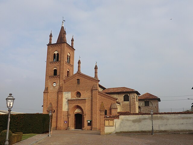
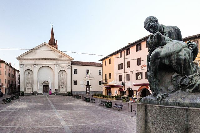
Racconigi (Racconigi)
- Italian comune
 Hiking in Racconigi
Racconigi, a charming town in the province of Cuneo, Piedmont, Italy, offers a variety of hiking opportunities in its beautiful natural surroundings. Here are some insights to help you plan your hiking experience in the area:
Hiking Trails
-
Parco del Castello di Racconigi: The area surrounding the historic Racconigi Castle features well-maintained paths that allow for leisurely walks among beautiful gardens and lush greenery. While not rigorous, these trails provide a scenic backdrop for a more relaxed hiking experience.
-
Sentiero del Po: This trail follows the River Po and offers beautiful views of the river landscape and local wildlife. It is a great option for those looking to enjoy nature while hiking along flat terrain.
-
Surrounding Nature Reserves: Venturing a bit outside Racconigi, you can explore nearby nature reserves and parks, such as the Bosco delle Navole and the Riserva Naturale Stagni di Casalbeltrame. These areas provide more challenging hikes with a chance to see a variety of flora and fauna.
-
Langhe and Roero Regions: For a more adventurous experience, consider hiking in the nearby hills of Langhe or Roero, which feature more elevation and stunning vineyard landscapes. These trails vary in difficulty and can provide panoramic views of the countryside.
Recommended Gear
- Footwear: Wear sturdy hiking boots for better traction and comfort.
- Clothing: Dress in layers to accommodate changing weather conditions. Breathable fabrics are advisable.
- Hydration: Carry enough water, especially for longer hikes.
- Navigation Tools: A local map or a hiking app can help you stay on track, as some trails may not be well-marked.
Best Times to Hike
- Spring (April to June): This is an ideal time, as the weather is mild, and wildflowers bloom.
- Autumn (September to November): Fall colors provide a stunning backdrop, and the temperatures are typically still comfortable for hiking.
Local Tips
- Respect Nature: Stay on marked trails and be mindful of local wildlife.
- Check Weather Conditions: Before heading out, check the weather forecast to ensure a safe hiking experience.
- Local Guides: Consider hiring a local guide for more challenging hikes or to discover hidden gems in the area.
Hiking in Racconigi offers a wonderful opportunity to experience the natural beauty and cultural heritage of this charming region. Enjoy your adventure!
- Country:

- Postal Code: 12035
- Local Dialing Code: 0172
- Licence Plate Code: CN
- Coordinates: 44° 46' 0" N, 7° 41' 0" E


- GPS tracks (wikiloc): [Link]
- AboveSeaLevel: 260 м m
- Area: 48.06 sq km
- Population: 9958
- Web site: http://www.comune.racconigi.cn.it
- Wikipedia en: wiki(en)
- Wikipedia: wiki(it)
- Wikidata storage: Wikidata: Q20376
- Wikipedia Commons Category: [Link]
- Freebase ID: [/m/0bgdll]
- GeoNames ID: Alt: [6542129]
- VIAF ID: Alt: [234312135]
- OSM relation ID: [43558]
- archINFORM location ID: [12597]
- Quora topic ID: [Racconigi]
- UN/LOCODE: [ITRAC]
- ISTAT ID: 004179
- Italian cadastre code: H150
Shares border with regions:
Caramagna Piemonte
- Italian comune
Hiking in Caramagna Piemonte
Caramagna Piemonte is a quaint municipality located in the province of Cuneo in the Piedmont region of Italy. While it may not be as widely recognized as some of the larger hiking destinations in the region, it offers some charming trails and beautiful landscapes for those looking to enjoy nature and outdoor activities....
- Country:
- Postal Code: 12030
- Local Dialing Code: 0172
- Licence Plate Code: CN
- Coordinates: 44° 47' 0" N, 7° 44' 0" E
- GPS tracks (wikiloc): [Link]
- AboveSeaLevel: 254 м m
- Area: 26.33 sq km
- Population: 3058
- Web site: [Link]
Casalgrasso
- Italian comune
Hiking in Casalgrasso
Casalgrasso is a small town in the Piedmont region of Italy, near Turin. While it may not be a major hiking destination like some larger national parks or mountainous areas, there are still opportunities for outdoor activities in and around the region....
- Country:
- Postal Code: 12030
- Local Dialing Code: 011
- Licence Plate Code: CN
- Coordinates: 44° 49' 0" N, 7° 38' 0" E
- GPS tracks (wikiloc): [Link]
- AboveSeaLevel: 240 м m
- Area: 17.81 sq km
- Population: 1444
- Web site: [Link]
Cavallerleone
- Italian comune
Hiking in Cavallerleone
Cavallerleone, located in the province of Cuneo in the Piedmont region of Italy, offers a unique landscape for hikers, characterized by its mix of picturesque rural scenery and expansive natural areas. While it may not be as widely known as some other hiking destinations, it serves as a gateway to the stunning trails in the surrounding areas, including the Maritime Alps....
- Country:
- Postal Code: 12030
- Local Dialing Code: 0172
- Licence Plate Code: CN
- Coordinates: 44° 44' 0" N, 7° 40' 0" E
- GPS tracks (wikiloc): [Link]
- AboveSeaLevel: 270 м m
- Area: 16.44 sq km
- Population: 683
- Web site: [Link]

Cavallermaggiore
- Italian comune
Hiking in Cavallermaggiore
Cavallermaggiore is a small town located in the Piedmont region of Italy, not far from the foothills of the Alps. While it may not be as widely known for hiking as some other areas in the Piedmont region, it offers access to beautiful landscapes and trails, particularly in the surrounding countryside and nearby hills....
- Country:
- Postal Code: 12030
- Local Dialing Code: 0172
- Licence Plate Code: CN
- Coordinates: 44° 43' 0" N, 7° 41' 0" E
- GPS tracks (wikiloc): [Link]
- AboveSeaLevel: 285 м m
- Area: 51.6 sq km
- Population: 5455
- Web site: [Link]
Murello
- Italian comune
Hiking in Murello
Murello, located in the Piedmont region of Italy, is surrounded by beautiful landscapes that offer various hiking opportunities. While Murello itself is a small town, it serves as a gateway to the stunning natural scenery of the surrounding areas, including the nearby Po River and the hills of the Monferrato region....
- Country:
- Postal Code: 12030
- Local Dialing Code: 0172
- Licence Plate Code: CN
- Coordinates: 44° 45' 11" N, 7° 36' 7" E
- GPS tracks (wikiloc): [Link]
- AboveSeaLevel: 260 м m
- Area: 17.33 sq km
- Population: 946
- Web site: [Link]

Polonghera
- Italian comune
Hiking in Polonghera
Polonghera is a small municipality located in the Piedmont region of northern Italy, nestled in the foothills of the Alps. While it may not be widely recognized as a major hiking destination, its surrounding landscapes offer opportunities for those looking to enjoy nature and explore less-traveled paths....
- Country:
- Postal Code: 12030
- Local Dialing Code: 011
- Licence Plate Code: CN
- Coordinates: 44° 48' 0" N, 7° 36' 0" E
- GPS tracks (wikiloc): [Link]
- AboveSeaLevel: 245 м m
- Area: 10.31 sq km
- Population: 1135
- Web site: [Link]
Sommariva del Bosco
- Italian comune
Hiking in Sommariva del Bosco
Sommariva del Bosco is a picturesque town located in the Piedmont region of Italy. It's surrounded by beautiful landscapes that provide excellent opportunities for hiking and outdoor activities. Here are some things to consider if you're planning to hike in and around Sommariva del Bosco:...
- Country:
- Postal Code: 12048
- Local Dialing Code: 0172
- Licence Plate Code: CN
- Coordinates: 44° 46' 0" N, 7° 47' 0" E
- GPS tracks (wikiloc): [Link]
- AboveSeaLevel: 298 м m
- Area: 35.42 sq km
- Population: 6321
- Web site: [Link]

Carmagnola
- Italian comune
Hiking in Carmagnola
Carmagnola is a charming town located in the Piedmont region of Italy, known for its agricultural background and beautiful landscapes. Although it may not be the first destination that comes to mind for hiking, there are several outdoor opportunities in and around the area....
- Country:
- Postal Code: 10022
- Local Dialing Code: 011
- Licence Plate Code: TO
- Coordinates: 44° 51' 0" N, 7° 43' 0" E
- GPS tracks (wikiloc): [Link]
- AboveSeaLevel: 240 м m
- Area: 95.72 sq km
- Population: 28976
- Web site: [Link]


Lombriasco
- Italian comune
Hiking in Lombriasco
Lombriasco is a small town located in the Piedmont region of northern Italy, near Turin. While it's not as well-known for hiking as some other areas in the region, it does offer opportunities for outdoor activities and exploration. Here are some insights into hiking in and around Lombriasco:...
- Country:
- Postal Code: 10040
- Local Dialing Code: 011
- Licence Plate Code: TO
- Coordinates: 44° 51' 0" N, 7° 38' 0" E
- GPS tracks (wikiloc): [Link]
- AboveSeaLevel: 241 м m
- Area: 7.21 sq km
- Population: 1035
- Web site: [Link]