Raisting (Raisting)
- municipality of Germany
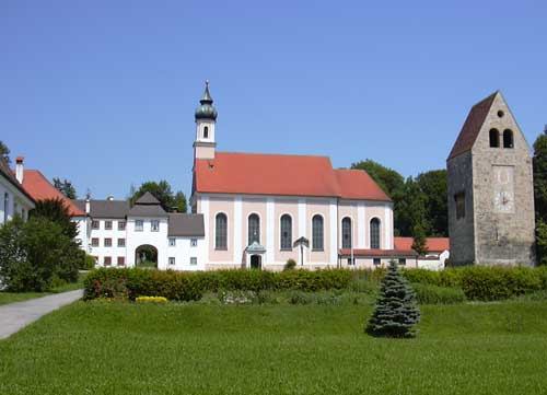
Raisting, located in Bavaria, Germany, offers beautiful hiking opportunities, particularly given its scenic landscapes and proximity to the Ammersee lake. Here are some key points to consider if you plan to hike in Raisting:
Terrain and Trails
- Gentle Terrain: The area around Raisting features mostly gentle hills and flat trails, which makes it suitable for hikers of all skill levels, including families and beginners.
- Marked Trails: There are several well-marked hiking trails that vary in length and difficulty. Popular routes take you through scenic meadows, woodlands, and along the shores of the Ammersee.
- Circular Routes: Many of the trails in the area offer circular routes, allowing you to start and end at the same point without backtracking.
Scenic Views
- Ammersee Lake: Hiking near the lake provides beautiful views, especially at sunset. The lake's reflective waters and surrounding landscape make for picturesque photo opportunities.
- Bavarian Countryside: The trails often include vistas of the charming Bavarian countryside, making for a peaceful and rejuvenating experience.
Wildlife and Flora
- Biodiversity: As you hike, keep an eye out for local wildlife and diverse plant species. The area's natural habitats support various birds, small mammals, and beautiful wildflowers in the spring and summer months.
Accessibility
- Transportation: Raisting is well connected by public transport, making it easy to access trailheads. Local buses or trains can take you to nearby towns with more extensive trail systems if desired.
- Facilities: You will find basic amenities such as rest areas and cafés in Raisting and the surrounding area to refresh yourself after a hike.
Safety and Preparation
- Weather: Always check the weather forecast before setting out, as conditions can change rapidly in this region.
- Gear: Good hiking shoes, weather-appropriate clothing, and enough water and snacks are essential for a comfortable hiking experience.
Conclusion
Hiking in Raisting is a great way to explore the natural beauty of Bavaria. Whether you prefer a leisurely stroll along the Ammersee or a more challenging hike through the hills, there are plenty of routes to choose from. Don't forget to enjoy the local culture and cuisine while visiting!
- Country:

- Postal Code: 82399
- Local Dialing Code: 08807
- Licence Plate Code: WM
- Coordinates: 47° 55' 0" N, 11° 6' 0" E


- GPS tracks (wikiloc): [Link]
- AboveSeaLevel: 553 м m
- Area: 21.98 sq km
- Population: 1541
- Web site: http://www.raisting.eu
- Wikipedia en: wiki(en)
- Wikipedia: wiki(de)
- Wikidata storage: Wikidata: Q538426
- Wikipedia Commons Category: [Link]
- Freebase ID: [/m/02rl96w]
- GeoNames ID: Alt: [6556440]
- VIAF ID: Alt: [246084100]
- OSM relation ID: [936834]
- GND ID: Alt: [2043665-8]
- archINFORM location ID: [13489]
- WOEID: [686690]
- Bavarikon ID: [ODB_A00001412]
- German municipality key: 09190144
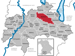
Shares border with regions:


Dießen am Ammersee
- municipality of Germany
Dießen am Ammersee is a picturesque town located in Bavaria, Germany, near the beautiful Ammersee Lake. It offers a variety of hiking opportunities that cater to different skill levels, providing stunning views of the lake, rolling hills, and surrounding countryside. Here are some highlights for hiking in the area:...
- Country:

- Postal Code: 86911
- Local Dialing Code: 08807
- Licence Plate Code: LL
- Coordinates: 47° 57' 3" N, 11° 6' 11" E


- GPS tracks (wikiloc): [Link]
- AboveSeaLevel: 535 м m
- Area: 82.64 sq km
- Population: 10326
- Web site: [Link]


Wielenbach
- municipality of Germany
Wielenbach is a picturesque municipality located in Bavaria, Germany, and it's surrounded by beautiful landscapes that make it a great destination for hiking enthusiasts. Here’s what you can expect when hiking in Wielenbach:...
- Country:

- Postal Code: 82407
- Local Dialing Code: 0881
- Licence Plate Code: WM
- Coordinates: 47° 52' 0" N, 11° 9' 0" E


- GPS tracks (wikiloc): [Link]
- AboveSeaLevel: 547 м m
- Area: 33.01 sq km
- Population: 2573
- Web site: [Link]


Wessobrunn
- municipality in Bavaria, Germany
Wessobrunn is a picturesque village located in Bavaria, Germany, surrounded by beautiful landscapes and offers various hiking opportunities that cater to different skill levels. Here’s an overview of what to expect when hiking in the area:...
- Country:

- Postal Code: 82405
- Local Dialing Code: 08809
- Licence Plate Code: WM
- Coordinates: 47° 53' 0" N, 11° 2' 0" E


- GPS tracks (wikiloc): [Link]
- AboveSeaLevel: 702 м m
- Area: 51.11 sq km
- Population: 1761
- Web site: [Link]


Pähl
- municipality of Germany
Pähl, located in Bavaria, Germany, offers some beautiful opportunities for hiking amidst picturesque landscapes. Here are some highlights and tips for hiking in and around Pähl:...
- Country:

- Postal Code: 82396
- Local Dialing Code: 08808
- Licence Plate Code: WM
- Coordinates: 47° 54' 0" N, 11° 11' 0" E


- GPS tracks (wikiloc): [Link]
- AboveSeaLevel: 590 м m
- Area: 32.04 sq km
- Population: 2374
- Web site: [Link]


Weilheim in Oberbayern
- town in Bavaria, Germany
 Hiking in Weilheim in Oberbayern
Weilheim in Oberbayern is a charming town located in Bavaria, Germany, surrounded by beautiful landscapes that make it a fantastic destination for hiking enthusiasts. The region is characterized by its rolling hills, forests, and proximity to the Alps, offering a variety of trails suitable for different skill levels....
- Country:

- Postal Code: 82362
- Local Dialing Code: 0881
- Licence Plate Code: WM
- Coordinates: 47° 50' 0" N, 11° 8' 0" E


- GPS tracks (wikiloc): [Link]
- AboveSeaLevel: 563 м m
- Area: 55.44 sq km
- Population: 22345
- Web site: [Link]
