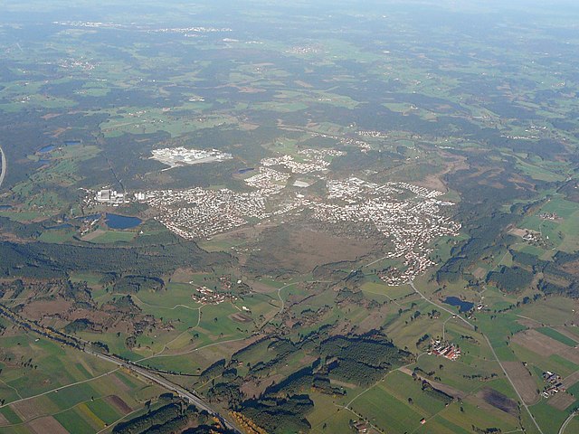
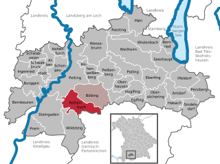
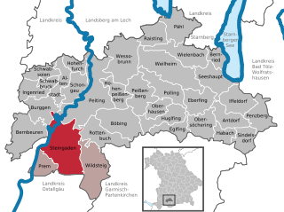
Weilheim-Schongau (Landkreis Weilheim-Schongau)

- district of Bavaria, Germany
 Hiking in Weilheim-Schongau
Weilheim-Schongau, located in Bavaria, Germany, is a fantastic area for hiking enthusiasts. The region is characterized by its stunning landscapes, which include rolling hills, lush forests, and the picturesque foothills of the Alps. Here are some highlights and recommendations for hiking in this beautiful region:
Trails and Routes
-
Ammergebirge Nature Park: This is one of the most popular hiking areas. The park features a range of trails from easy walks to challenging hikes. The trails often lead through scenic woods and offer spectacular mountain views.
-
Murnauer Moos: This is an extensive peat bog area that offers unique flora and fauna. A network of trails allows for easy access to observe the rich biodiversity and learn about the ecosystem.
-
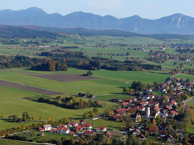
Kochelsee and Walchensee: Both lakes are surrounded by hiking paths that offer stunning views of the water and the mountains. The route around Lake Walchensee is particularly popular for its scenic beauty.
-
Hiking to Mount Herzogstand: For those seeking a challenge, the hike to the Herzogstand offers breathtaking views over the surrounding Alps and lakes. It's a well-marked trail suitable for experienced hikers.
Hike Difficulty
The Weilheim-Schongau region has trails suitable for all hiking levels, from gentle family-friendly walks to more strenuous mountain hikes. Always check the trail difficulty and your physical fitness before setting out.
Safety and Preparedness
- Navigation: Make sure to carry a map or use a suitable app for navigation, as some trails can be remote.
- Weather Conditions: Weather in Bavaria can change rapidly, especially in the mountains. Check forecasts and be prepared with appropriate clothing.
- Wildlife: Respect the local wildlife and stay on marked paths.
Local Tips
- Visitor Centers: Stop by local visitor centers for maps, trail information, and recommendations.
- Accommodation: There are various options ranging from hotels to guesthouses, as well as campsites for those looking to immerse themselves in nature.
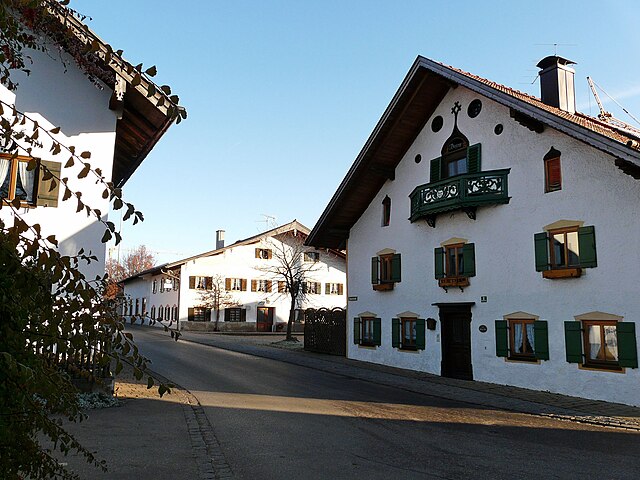
- Cultural Experience: Consider exploring local villages and enjoying Bavarian cuisine after your hike, as the region is known for its hospitality.
Hiking in Weilheim-Schongau is a rewarding experience that combines natural beauty with cultural richness. Whether you're a seasoned hiker or a beginner, you'll find trails that suit your desire for adventure!
- Country:

- Capital: Weilheim in Oberbayern
- Licence Plate Code: SOG; WM
- Coordinates: 47° 49' 48" N, 11° 0' 0" E


- GPS tracks (wikiloc): [Link]
- AboveSeaLevel: 647 м m
- Area: 966.22 sq km
- Population: 106376
- Web site: http://www.weilheim-schongau.de/
- Wikipedia en: wiki(en)
- Wikipedia: wiki(de)
- Wikidata storage: Wikidata: Q10516
- Wikipedia Commons Category: [Link]
- Wikipedia Commons Maps Category: [Link]
- Freebase ID: [/m/02j9sc]
- GeoNames ID: Alt: [3220842]
- VIAF ID: Alt: [438145424618786831484]
- OSM relation ID: [62600]
- GND ID: Alt: [4107882-2]
- archINFORM location ID: [114]
- TGN ID: [7077288]
- Bavarikon ID: [ODB_A00001389]
- NUTS code: [DE21N]
- German district key: 09190
Includes regions:

Penzberg
- town in Bavaria, Germany
Hiking in Penzberg
Penzberg, located in Bavaria, Germany, offers a variety of hiking opportunities that cater to different skill levels and preferences. The region is known for its stunning landscapes, which include rolling hills, forests, and panoramic views of the Alps. Here are some highlights and tips for hiking in Penzberg:...
- Country:
- Postal Code: 82377
- Local Dialing Code: 08856
- Licence Plate Code: WM
- Coordinates: 47° 45' 0" N, 11° 22' 0" E
- GPS tracks (wikiloc): [Link]
- AboveSeaLevel: 596 м m
- Area: 25.73 sq km
- Population: 12949
- Web site: [Link]

Obersöchering
- municipality of Germany
Hiking in Obersöchering
Obersöchering is a quaint village located in Bavaria, Germany, surrounded by beautiful natural landscapes, making it an excellent destination for hiking enthusiasts. The region features a variety of trails that cater to hikers of all skill levels, from leisurely walks to more challenging routes....
- Country:
- Postal Code: 82395
- Local Dialing Code: 08847
- Licence Plate Code: WM
- Coordinates: 47° 44' 0" N, 11° 13' 0" E
- GPS tracks (wikiloc): [Link]
- AboveSeaLevel: 665 м m
- Area: 24.27 sq km
- Population: 1064
- Web site: [Link]


Polling
- municipality in the Weilheim-Schongau district, in Bavaria, Germany.
Hiking in Polling
Polling, located in the Weilheim-Schongau district of Bavaria, Germany, is surrounded by beautiful landscapes that make it a lovely destination for hiking enthusiasts. The area is characterized by rolling hills, lush forests, and picturesque views, making it ideal for various hiking activities....
- Country:
- Postal Code: 82398
- Local Dialing Code: 0881
- Licence Plate Code: WM
- Coordinates: 47° 48' 40" N, 11° 7' 51" E
- GPS tracks (wikiloc): [Link]
- AboveSeaLevel: 567 м m
- Area: 29.2 sq km
- Population: 2629
- Web site: [Link]


Iffeldorf
- municipality of Germany
Hiking in Iffeldorf
Iffeldorf, located in Bavaria, Germany, is surrounded by picturesque landscapes, making it a great destination for hiking enthusiasts. The region features rolling hills, lush forests, and scenic views of the Alps in the distance....
- Country:
- Postal Code: 82393
- Local Dialing Code: 08856
- Licence Plate Code: WM
- Coordinates: 47° 46' 16" N, 11° 19' 10" E
- GPS tracks (wikiloc): [Link]
- AboveSeaLevel: 603 м m
- Area: 27.59 sq km
- Population: 1942
- Web site: [Link]


Habach
- municipality of Germany
Hiking in Habach
Habach, nestled in the stunning landscapes of the Austrian Alps, is a fantastic destination for hikers of all levels. The region is characterized by its scenic beauty, diverse terrain, and a network of well-marked hiking trails that cater to different skill levels....
- Country:
- Postal Code: 82392
- Local Dialing Code: 08847
- Licence Plate Code: WM
- Coordinates: 47° 44' 0" N, 11° 17' 0" E
- GPS tracks (wikiloc): [Link]
- AboveSeaLevel: 652 м m
- Area: 12.15 sq km
- Population: 723
- Web site: [Link]


Wielenbach
- municipality of Germany
Hiking in Wielenbach
Wielenbach is a picturesque municipality located in Bavaria, Germany, and it's surrounded by beautiful landscapes that make it a great destination for hiking enthusiasts. Here’s what you can expect when hiking in Wielenbach:...
- Country:
- Postal Code: 82407
- Local Dialing Code: 0881
- Licence Plate Code: WM
- Coordinates: 47° 52' 0" N, 11° 9' 0" E
- GPS tracks (wikiloc): [Link]
- AboveSeaLevel: 547 м m
- Area: 33.01 sq km
- Population: 2573
- Web site: [Link]


Bernried am Starnberger See
- municipality in Bavaria, Germany
Hiking in Bernried am Starnberger See
Bernried am Starnberger See is a picturesque village located on the shores of Lake Starnberg in Bavaria, Germany. It’s an excellent destination for hiking enthusiasts, offering a blend of scenic views, nature trails, and a tranquil atmosphere. Here are some highlights and considerations for hiking in this area:...
- Country:
- Postal Code: 82347
- Local Dialing Code: 08158
- Licence Plate Code: WM
- Coordinates: 47° 52' 0" N, 11° 18' 0" E
- GPS tracks (wikiloc): [Link]
- AboveSeaLevel: 583 м m
- Area: 13.79 sq km
- Population: 2251
- Web site: [Link]


Eberfing
- municipality of Germany
Hiking in Eberfing
Eberfing is a small municipality located in Bavaria, Germany, known for its picturesque landscapes and outdoor activities, including hiking. The region offers a variety of hiking trails that cater to different skill levels, making it suitable for both beginners and experienced hikers....
- Country:
- Postal Code: 82390
- Local Dialing Code: 08802
- Licence Plate Code: WM
- Coordinates: 47° 48' 0" N, 11° 12' 0" E
- GPS tracks (wikiloc): [Link]
- AboveSeaLevel: 611 м m
- Area: 25.93 sq km
- Population: 872
- Web site: [Link]


Altenstadt
- municipality in Upper Bavaria
Hiking in Altenstadt
Altenstadt, located in Upper Bavaria, is a charming town that serves as an excellent base for various hiking adventures. The region is characterized by its picturesque landscapes, with rolling hills, forests, and a network of well-marked trails. Here are some highlights and tips for hiking in and around Altenstadt:...
- Country:
- Postal Code: 86972
- Local Dialing Code: 08861
- Licence Plate Code: WM
- Coordinates: 47° 49' 0" N, 10° 52' 0" E
- GPS tracks (wikiloc): [Link]
- AboveSeaLevel: 716 м m
- Area: 18.66 sq km
- Population: 2870
- Web site: [Link]


Sindelsdorf
- municipality of Germany
Hiking in Sindelsdorf
Sindelsdorf, a charming village located in Bavaria, Germany, offers stunning landscapes and several hiking opportunities that cater to various skill levels. The surrounding region boasts picturesque scenery, including rolling hills, lush forests, and scenic views of the Alps in the distance....
- Country:
- Postal Code: 82404
- Local Dialing Code: 08856
- Licence Plate Code: WM
- Coordinates: 47° 43' 24" N, 11° 19' 57" E
- GPS tracks (wikiloc): [Link]
- AboveSeaLevel: 609 м m
- Area: 17.5 sq km
- Population: 783
- Web site: [Link]


Schwabsoien
- municipality of Germany
Hiking in Schwabsoien
Schwabsoien is a picturesque village in Bavaria, Germany, surrounded by beautiful landscapes that make it a great destination for hiking enthusiasts. The region offers various trails catering to different skill levels, all of which provide stunning views of the Bavarian countryside, forests, and distant mountains....
- Country:
- Postal Code: 86987
- Local Dialing Code: 08868
- Licence Plate Code: WM
- Coordinates: 47° 50' 0" N, 10° 50' 0" E
- GPS tracks (wikiloc): [Link]
- AboveSeaLevel: 746 м m
- Area: 17.02 sq km
- Population: 1072
- Web site: [Link]


Schwabbruck
- municipality of Germany
Hiking in Schwabbruck
Schwabbruck, located in the picturesque region of Bavaria, Germany, offers a range of hiking opportunities for both novice and experienced hikers. With the stunning backdrop of the Alps and lush green landscapes, Schwabbruck serves as an excellent starting point for exploring the natural beauty of the area....
- Country:
- Postal Code: 86986
- Local Dialing Code: 08868
- Licence Plate Code: WM
- Coordinates: 47° 50' 0" N, 10° 50' 0" E
- GPS tracks (wikiloc): [Link]
- AboveSeaLevel: 733 м m
- Area: 7.34 sq km
- Population: 714
- Web site: [Link]


Bernbeuren
- municipality of Germany
Hiking in Bernbeuren
Bernbeuren, a picturesque village in Bavaria, Germany, offers a variety of hiking opportunities for both novice and experienced hikers. Nestled in the foothills of the Alps, the region is characterized by stunning landscapes, lush valleys, and panoramic mountain views. Here are some highlights and tips for hiking in Bernbeuren:...
- Country:
- Postal Code: 86975
- Local Dialing Code: 08860
- Licence Plate Code: WM
- Coordinates: 47° 44' 17" N, 10° 46' 43" E
- GPS tracks (wikiloc): [Link]
- AboveSeaLevel: 773 м m
- Area: 41.69 sq km
- Population: 1820
- Web site: [Link]


Hohenfurch
- municipality of Germany
Hiking in Hohenfurch
Hohenfurch is a picturesque village located in Bavaria, Germany, surrounded by beautiful landscapes that are ideal for hiking enthusiasts. The area offers a blend of natural beauty, rolling hills, lush forests, and scenic trails, making it a fantastic destination for outdoor activities....
- Country:
- Postal Code: 86978
- Local Dialing Code: 08861
- Licence Plate Code: WM
- Coordinates: 47° 51' 0" N, 10° 54' 0" E
- GPS tracks (wikiloc): [Link]
- AboveSeaLevel: 699 м m
- Area: 12.41 sq km
- Population: 1567
- Web site: [Link]


Ingenried
- municipality of Germany
Hiking in Ingenried
Ingenried is a charming village located in Bavaria, Germany, surrounded by beautiful landscapes that are ideal for hiking enthusiasts. Here are some highlights about hiking in Ingenried and the surrounding areas:...
- Country:
- Postal Code: 86980
- Local Dialing Code: 08868
- Licence Plate Code: WM
- Coordinates: 47° 49' 0" N, 10° 47' 0" E
- GPS tracks (wikiloc): [Link]
- AboveSeaLevel: 664 м m
- Area: 17.45 sq km
- Population: 687
- Web site: [Link]

Eglfing
- municipality of Germany
Hiking in Eglfing
Eglfing, located in Bavaria, Germany, is a lesser-known destination for hiking enthusiasts. While not as popular as some larger Bavarian areas, it offers beautiful landscapes and serene trails that attract those looking for a peaceful outdoor experience....
- Country:
- Postal Code: 82436
- Local Dialing Code: 08847
- Licence Plate Code: WM
- Coordinates: 47° 44' 0" N, 11° 11' 0" E
- GPS tracks (wikiloc): [Link]
- AboveSeaLevel: 652 м m
- Area: 16.16 sq km
- Population: 1049
- Web site: [Link]


Böbing
- municipality of Germany
Hiking in Böbing
Böbing is a picturesque village located in Bavaria, Germany, and is surrounded by beautiful natural landscapes ideal for hiking enthusiasts. The region offers various trails that cater to different skill levels, from easy walks to challenging hikes....
- Country:
- Postal Code: 82389
- Local Dialing Code: 08867
- Licence Plate Code: WM
- Coordinates: 47° 45' 0" N, 10° 59' 0" E
- GPS tracks (wikiloc): [Link]
- AboveSeaLevel: 750 м m
- Area: 40.32 sq km
- Population: 1396
- Web site: [Link]


Huglfing
- municipality of Germany
Hiking in Huglfing
Huglfing is a charming town in Bavaria, Germany, known for its picturesque landscapes and access to beautiful hiking trails. The region offers a mix of scenic countryside, forests, and rolling hills, making it a great destination for outdoor enthusiasts....
- Country:
- Postal Code: 82386
- Local Dialing Code: 08802
- Licence Plate Code: WM
- Coordinates: 47° 46' 0" N, 11° 10' 0" E
- GPS tracks (wikiloc): [Link]
- AboveSeaLevel: 606 м m
- Area: 24.36 sq km
- Population: 1864
- Web site: [Link]


Wildsteig
- municipality of Germany
Hiking in Wildsteig
Wildsteig is a picturesque village located in the Bavarian region of Germany, nestled in the heart of the Ammergebirge Nature Park. Hiking in and around Wildsteig offers a wonderful experience for both beginners and seasoned hikers, featuring a diverse range of trails, stunning natural landscapes, and rich local culture....
- Country:
- Postal Code: 82409
- Local Dialing Code: 08867
- Licence Plate Code: WM
- Coordinates: 47° 42' 0" N, 10° 57' 0" E
- GPS tracks (wikiloc): [Link]
- AboveSeaLevel: 875 м m
- Area: 47.73 sq km
- Population: 1024
- Web site: [Link]


Seeshaupt
- municipality of Germany
Hiking in Seeshaupt
Seeshaupt is a beautiful village located on the southern edge of Lake Starnberg in Bavaria, Germany. It’s a fantastic destination for hiking enthusiasts, offering a variety of trails that showcase the stunning natural beauty of the area. Here are some key points to consider if you're planning a hiking trip in Seeshaupt:...
- Country:
- Postal Code: 82402
- Local Dialing Code: 08801
- Licence Plate Code: WM
- Coordinates: 47° 49' 28" N, 11° 18' 3" E
- GPS tracks (wikiloc): [Link]
- AboveSeaLevel: 497 м m
- Area: 29.97 sq km
- Population: 3108
- Web site: [Link]

Peiting
- municipality of Germany
Hiking in Peiting
Peiting, located in the Bavarian region of Germany, is surrounded by beautiful landscapes that are perfect for hiking enthusiasts. The town itself is situated near the rolling hills of the Ammergebirge Nature Park and is close to the foothills of the Alps, offering a variety of hiking trails suited for different skill levels....
- Country:
- Postal Code: 86971
- Local Dialing Code: 08861
- Licence Plate Code: WM
- Coordinates: 47° 48' 0" N, 10° 56' 0" E
- GPS tracks (wikiloc): [Link]
- AboveSeaLevel: 718 м m
- Area: 75.14 sq km
- Population: 10319
- Web site: [Link]

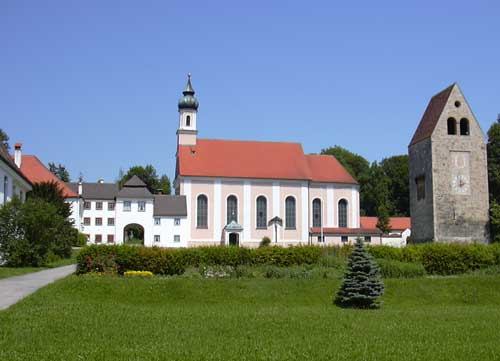
Rottenbuch
- municipality of Germany
Hiking in Rottenbuch
Rottenbuch is a charming village located in Bavaria, Germany, situated at the edge of the beautiful Ammergebirge Nature Park. It offers a variety of hiking opportunities with stunning views of the surrounding landscape, including the Bavarian Alps....
- Country:
- Postal Code: 82401
- Local Dialing Code: 08867
- Licence Plate Code: WM
- Coordinates: 47° 44' 5" N, 10° 58' 0" E
- GPS tracks (wikiloc): [Link]
- AboveSeaLevel: 763 м m
- Area: 31.48 sq km
- Population: 1551
- Web site: [Link]


Schongau
- town in Bavaria, Germany
Hiking in Schongau
Schongau, located in Bavaria, Germany, is a charming town surrounded by beautiful landscapes, making it an excellent destination for hiking enthusiasts. Nestled in the foothills of the Bavarian Alps, the area offers a variety of trails that cater to different skill levels, from leisurely walks to more challenging hikes....
- Country:
- Postal Code: 86956
- Local Dialing Code: 08861
- Coordinates: 47° 49' 0" N, 10° 54' 0" E
- GPS tracks (wikiloc): [Link]
- AboveSeaLevel: 710 м m
- Area: 21.35 sq km
- Population: 10182
- Web site: [Link]

Wessobrunn
- municipality in Bavaria, Germany
Hiking in Wessobrunn
Wessobrunn is a picturesque village located in Bavaria, Germany, surrounded by beautiful landscapes and offers various hiking opportunities that cater to different skill levels. Here’s an overview of what to expect when hiking in the area:...
- Country:
- Postal Code: 82405
- Local Dialing Code: 08809
- Licence Plate Code: WM
- Coordinates: 47° 53' 0" N, 11° 2' 0" E
- GPS tracks (wikiloc): [Link]
- AboveSeaLevel: 702 м m
- Area: 51.11 sq km
- Population: 1761
- Web site: [Link]


Peißenberg
- municipality of Germany
Hiking in Peißenberg
Peißenberg, located in Bavaria, Germany, is surrounded by beautiful landscapes and offers a variety of hiking opportunities for outdoor enthusiasts. Situated near the Ammer Mountains and the foothills of the Alps, hikers can enjoy stunning views, diverse terrains, and a mix of easy to challenging trails. Here are some highlights about hiking in Peißenberg:...
- Country:
- Postal Code: 82380
- Local Dialing Code: 08803
- Licence Plate Code: WM
- Coordinates: 47° 47' 42" N, 11° 3' 37" E
- GPS tracks (wikiloc): [Link]
- AboveSeaLevel: 584 м m
- Area: 32.69 sq km
- Population: 10675
- Web site: [Link]


Prem
- municipality of Germany
Hiking in Prem
Hiking in Prem, Bavaria, offers stunning landscapes and a variety of trails that cater to different skill levels. Here's what you can expect when exploring this beautiful region:...
- Country:
- Postal Code: 86984
- Local Dialing Code: 08862
- Licence Plate Code: WM
- Coordinates: 47° 41' 0" N, 10° 48' 0" E
- GPS tracks (wikiloc): [Link]
- AboveSeaLevel: 733 м m
- Area: 15.91 sq km
- Population: 818
- Web site: [Link]


Pähl
- municipality of Germany
Hiking in Pähl
Pähl, located in Bavaria, Germany, offers some beautiful opportunities for hiking amidst picturesque landscapes. Here are some highlights and tips for hiking in and around Pähl:...
- Country:
- Postal Code: 82396
- Local Dialing Code: 08808
- Licence Plate Code: WM
- Coordinates: 47° 54' 0" N, 11° 11' 0" E
- GPS tracks (wikiloc): [Link]
- AboveSeaLevel: 590 м m
- Area: 32.04 sq km
- Population: 2374
- Web site: [Link]

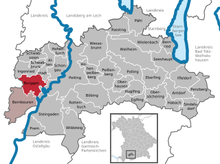
Burggen
- municipality of Germany
Hiking in Burggen
Burggen is a charming area located in Bavaria, Germany, known for its picturesque landscapes and outdoor activities, including hiking. The region offers a variety of trails that cater to different skill levels, from easy walks to more challenging hikes....
- Country:
- Postal Code: 86977
- Local Dialing Code: 08860
- Licence Plate Code: WM
- Coordinates: 47° 47' 0" N, 10° 49' 0" E
- GPS tracks (wikiloc): [Link]
- AboveSeaLevel: 756 м m
- Area: 24.94 sq km
- Population: 1298
- Web site: [Link]


Antdorf
- municipality of Germany
Hiking in Antdorf
Antdorf is a charming village located in Bavaria, Germany, known for its picturesque landscapes and proximity to hiking trails that cater to a variety of outdoor enthusiasts. Here’s what you can expect when hiking in and around Antdorf:...
- Country:
- Postal Code: 82387
- Local Dialing Code: 08856
- Licence Plate Code: WM
- Coordinates: 47° 45' 0" N, 11° 18' 0" E
- GPS tracks (wikiloc): [Link]
- AboveSeaLevel: 631 м m
- Area: 22.37 sq km
- Population: 927
- Web site: [Link]


Oberhausen
- municipality in the district of Weilheim-Schongau, Upper Bavaria, Germany
Hiking in Oberhausen
Oberhausen, located in the Weilheim-Schongau district of Bavaria, Germany, is a great spot for hiking enthusiasts. The region is characterized by its beautiful landscapes, rolling hills, and scenic views of the surrounding mountains, making it an attractive destination for both casual walkers and serious hikers....
- Country:
- Postal Code: 82386
- Local Dialing Code: 08802
- Licence Plate Code: WM
- Coordinates: 47° 47' 0" N, 11° 8' 0" E
- GPS tracks (wikiloc): [Link]
- AboveSeaLevel: 611 м m
- Area: 14.91 sq km
- Population: 1503
- Web site: [Link]
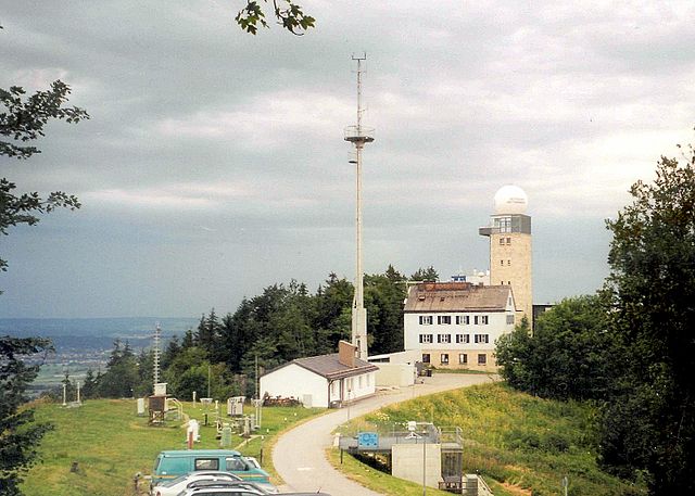

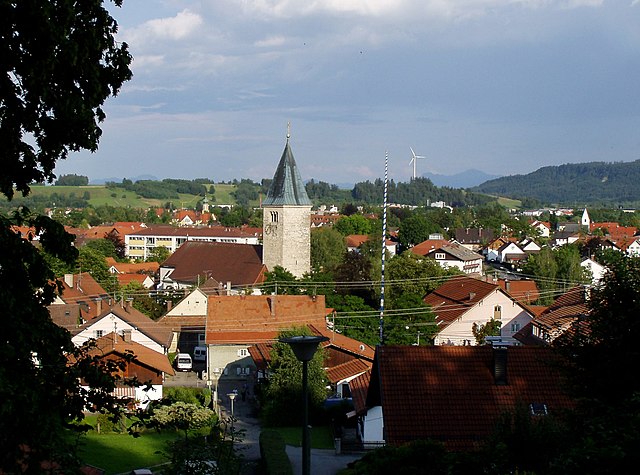
Hohenpeißenberg
- municipality of Germany
Hiking in Hohenpeißenberg
Hohenpeißenberg is a popular hiking destination in Bavaria, Germany, known for its stunning panoramic views and scenic trails. Here’s an overview of hiking in this beautiful area:...
- Country:
- Postal Code: 82383
- Local Dialing Code: 08805
- Licence Plate Code: WM
- Coordinates: 47° 48' 0" N, 11° 0' 0" E
- GPS tracks (wikiloc): [Link]
- AboveSeaLevel: 780 м m
- Area: 20.44 sq km
- Population: 3231
- Web site: [Link]

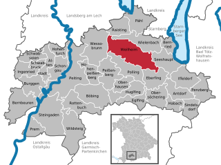
Weilheim in Oberbayern
- town in Bavaria, Germany
Hiking in Weilheim in Oberbayern
Weilheim in Oberbayern is a charming town located in Bavaria, Germany, surrounded by beautiful landscapes that make it a fantastic destination for hiking enthusiasts. The region is characterized by its rolling hills, forests, and proximity to the Alps, offering a variety of trails suitable for different skill levels....
- Country:
- Postal Code: 82362
- Local Dialing Code: 0881
- Licence Plate Code: WM
- Coordinates: 47° 50' 0" N, 11° 8' 0" E
- GPS tracks (wikiloc): [Link]
- AboveSeaLevel: 563 м m
- Area: 55.44 sq km
- Population: 22345
- Web site: [Link]


Raisting
- municipality of Germany
Hiking in Raisting
Raisting, located in Bavaria, Germany, offers beautiful hiking opportunities, particularly given its scenic landscapes and proximity to the Ammersee lake. Here are some key points to consider if you plan to hike in Raisting:...
- Country:
- Postal Code: 82399
- Local Dialing Code: 08807
- Licence Plate Code: WM
- Coordinates: 47° 55' 0" N, 11° 6' 0" E
- GPS tracks (wikiloc): [Link]
- AboveSeaLevel: 553 м m
- Area: 21.98 sq km
- Population: 1541
- Web site: [Link]

Steingaden
- municipality of Germany
Hiking in Steingaden
Steingaden is a picturesque village located in Bavaria, Germany, and is known for its stunning natural landscapes and proximity to the Alps. Hiking in the Steingaden area offers a variety of trails suitable for different skill levels, making it a great destination for both beginners and experienced hikers. Here are some highlights and information about hiking in Steingaden:...
- Country:
- Postal Code: 86989
- Local Dialing Code: 08862
- Licence Plate Code: WM
- Coordinates: 47° 42' 0" N, 10° 52' 0" E
- GPS tracks (wikiloc): [Link]
- AboveSeaLevel: 763 м m
- Area: 64.09 sq km
- Population: 2744
- Web site: [Link]
Shares border with regions:

Ostallgäu
- district in Bavaria, Germany
Hiking in Ostallgäu
Ostallgäu is a picturesque region in Bavaria, Germany, known for its stunning landscapes dominated by the Alps, rolling hills, and charming villages. It's an excellent destination for hiking, offering a variety of trails suitable for different skill levels, from beginner to advanced. Here are some key highlights of hiking in Ostallgäu:...
- Country:
- Capital: Marktoberdorf
- Licence Plate Code: OAL; MOD; FÜS
- Coordinates: 47° 45' 0" N, 10° 34' 48" E
- GPS tracks (wikiloc): [Link]
- AboveSeaLevel: 724 м m
- Area: 1395.00 sq km
- Population: 114547
- Web site: [Link]
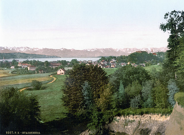
Starnberg
- district of Bavaria, Germany
Hiking in Starnberg
Hiking in the Starnberg district, located in Bavaria, Germany, offers a beautiful blend of scenic landscapes, including lakes, forests, and picturesque villages. Here are some highlights and tips for hiking in the area:...
- Country:
- Capital: Starnberg
- Licence Plate Code: WOR; STA
- Coordinates: 48° 0' 36" N, 11° 16' 48" E
- GPS tracks (wikiloc): [Link]
- AboveSeaLevel: 683 м m
- Area: 488.01 sq km
- Population: 108887
- Web site: [Link]

Landsberg
- district of Bavaria, Germany
Hiking in Landsberg
Landsberg district, located in Bavaria, Germany, is a beautiful area that offers a variety of hiking opportunities amidst stunning natural landscapes. The region is characterized by its rolling hills, lush forests, and picturesque lakes, making it an ideal destination for outdoor enthusiasts. Here are some key points about hiking in Landsberg district:...
- Country:
- Capital: Landsberg am Lech
- Licence Plate Code: LL
- Coordinates: 48° 1' 12" N, 10° 57' 0" E
- GPS tracks (wikiloc): [Link]
- AboveSeaLevel: 636 м m
- Area: 804.00 sq km
- Population: 83612
- Web site: [Link]


Garmisch-Partenkirchen
- district of Bavaria, Germany
Hiking in Garmisch-Partenkirchen
Garmisch-Partenkirchen is a beautiful district located in Bavaria, Germany, and is renowned for its stunning alpine scenery and outdoor recreational activities, making it a popular destination for hikers. Here are some key points about hiking in this picturesque area:...
- Country:
- Capital: Garmisch-Partenkirchen
- Licence Plate Code: GAP
- Coordinates: 47° 34' 48" N, 11° 10' 12" E
- GPS tracks (wikiloc): [Link]
- AboveSeaLevel: 1296 м m
- Area: 1012.00 sq km
- Population: 78782
- Web site: [Link]

Bad Tölz-Wolfratshausen
- district of Bavaria, Germany
Hiking in Bad Tölz-Wolfratshausen
Bad Tölz-Wolfratshausen is a picturesque region in Bavaria, Germany, known for its stunning landscapes and excellent hiking opportunities. Nestled in the foothills of the Alps, this area offers a variety of trails that cater to different skill levels, from gentle walks suitable for families to more challenging hikes for experienced adventurers....
- Country:
- Capital: Bad Tölz
- Licence Plate Code: WOR; TÖL
- Coordinates: 47° 45' 0" N, 11° 34' 48" E
- GPS tracks (wikiloc): [Link]
- AboveSeaLevel: 848 м m
- Area: 1111.00 sq km
- Population: 126572
- Web site: [Link]