Wessobrunn (Wessobrunn)
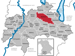
- municipality in Bavaria, Germany
Wessobrunn is a picturesque village located in Bavaria, Germany, surrounded by beautiful landscapes and offers various hiking opportunities that cater to different skill levels. Here’s an overview of what to expect when hiking in the area:
Scenic Trails
Wessobrunn is known for its scenic trails that traverse lush forests, rolling hills, and scenic meadows. The landscape is characterized by its natural beauty, and hikers can enjoy picturesque spots along the way.
Notable Hiking Routes
-
The Wessobrunn Trail: This local route often highlights the village's historical and cultural aspects, taking you past landmarks like the famous Wessobrunn Abbey, known for its Baroque architecture.
-
Nature Trails: There are various nature trails that offer educational insights into the region's flora and fauna. These paths are well-marked and provide a great way for families to explore the area.
-
Long-distance Trails: For more experienced hikers, there are connections to longer regional trails that delve deeper into the Bavarian Forest or the nearby Ammergebirge Nature Park, providing more challenging hikes with stunning panoramic views.
Seasonal Considerations
- Spring and Summer: With blooming wildflowers and pleasant weather, the best time for hiking is during the warmer months. It’s an excellent time for birdwatching and enjoying the lush greenery.
- Autumn: Fall foliage transforms the landscape into a canvas of color, making it a breathtaking time to hike.
- Winter: Snow-covered trails can offer a different kind of beauty, and it's possible to strap on snowshoes for a unique winter hiking experience.
Preparation Tips
- Trail Maps: Always carry a trail map or smartphone app with local hiking routes, as some paths might not be well marked.
- Footwear: Sturdy hiking boots are recommended to tackle various terrains.
- Weather: Check the weather forecast prior to your hike, as conditions can change quickly in the mountains.
Access and Amenities
Wessobrunn is accessible by car and public transport, with nearby towns providing amenities such as restaurants and accommodations. Make sure to hydrate and pack snacks, especially for longer hikes.
Local Culture
Take the time to appreciate the local culture, including regional delicacies and hospitality, at eateries in the village after your hike. Wessobrunn's quiet charm adds to the hiking experience, making it more memorable.
In summary, Wessobrunn offers a delightful mix of natural beauty and cultural heritage, making it a wonderful location for hiking enthusiasts. Whether you're looking for a leisurely walk or an invigorating trek, this area has something to offer.
- Country:

- Postal Code: 82405
- Local Dialing Code: 08809
- Licence Plate Code: WM
- Coordinates: 47° 53' 0" N, 11° 2' 0" E


- GPS tracks (wikiloc): [Link]
- AboveSeaLevel: 702 м m
- Area: 51.11 sq km
- Population: 1761
- Web site: http://www.wessobrunn.de
- Wikipedia en: wiki(en)
- Wikipedia: wiki(de)
- Wikidata storage: Wikidata: Q520922
- Wikipedia Commons Category: [Link]
- Freebase ID: [/m/02pc4kf]
- GeoNames ID: Alt: [6556447]
- VIAF ID: Alt: [135301891]
- OSM relation ID: [936793]
- GND ID: Alt: [4065739-5]
- archINFORM location ID: [8495]
- Library of Congress authority ID: Alt: [nr89017322]
- WOEID: [705641]
- Encyclopædia Britannica Online ID: [place/Wessobrunn]
- Historical Gazetteer (GOV) ID: [object_300615]
- Bavarikon ID: [ODB_A00001421]
- Catholic Encyclopedia ID: [15591a]
- German municipality key: 09190158
Shares border with regions:


Dießen am Ammersee
- municipality of Germany
Dießen am Ammersee is a picturesque town located in Bavaria, Germany, near the beautiful Ammersee Lake. It offers a variety of hiking opportunities that cater to different skill levels, providing stunning views of the lake, rolling hills, and surrounding countryside. Here are some highlights for hiking in the area:...
- Country:

- Postal Code: 86911
- Local Dialing Code: 08807
- Licence Plate Code: LL
- Coordinates: 47° 57' 3" N, 11° 6' 11" E


- GPS tracks (wikiloc): [Link]
- AboveSeaLevel: 535 м m
- Area: 82.64 sq km
- Population: 10326
- Web site: [Link]


Polling
- municipality in the Weilheim-Schongau district, in Bavaria, Germany.
Polling, located in the Weilheim-Schongau district of Bavaria, Germany, is surrounded by beautiful landscapes that make it a lovely destination for hiking enthusiasts. The area is characterized by rolling hills, lush forests, and picturesque views, making it ideal for various hiking activities....
- Country:

- Postal Code: 82398
- Local Dialing Code: 0881
- Licence Plate Code: WM
- Coordinates: 47° 48' 40" N, 11° 7' 51" E


- GPS tracks (wikiloc): [Link]
- AboveSeaLevel: 567 м m
- Area: 29.2 sq km
- Population: 2629
- Web site: [Link]


Rott
- municipality of Germany
Rott, located near Landsberg am Lech in Bavaria, Germany, is a charming area that offers opportunities for hiking amidst beautiful natural scenery. The region is characterized by rolling hills, woodlands, and agricultural landscapes, making it a picturesque setting for outdoor enthusiasts....
- Country:

- Postal Code: 86935
- Local Dialing Code: 08869
- Licence Plate Code: LL
- Coordinates: 47° 54' 0" N, 10° 58' 0" E


- GPS tracks (wikiloc): [Link]
- AboveSeaLevel: 702 м m
- Area: 19.73 sq km
- Population: 1018
- Web site: [Link]


Peiting
- municipality of Germany
Peiting, located in the Bavarian region of Germany, is surrounded by beautiful landscapes that are perfect for hiking enthusiasts. The town itself is situated near the rolling hills of the Ammergebirge Nature Park and is close to the foothills of the Alps, offering a variety of hiking trails suited for different skill levels....
- Country:

- Postal Code: 86971
- Local Dialing Code: 08861
- Licence Plate Code: WM
- Coordinates: 47° 48' 0" N, 10° 56' 0" E


- GPS tracks (wikiloc): [Link]
- AboveSeaLevel: 718 м m
- Area: 75.14 sq km
- Population: 10319
- Web site: [Link]


Peißenberg
- municipality of Germany
Peißenberg, located in Bavaria, Germany, is surrounded by beautiful landscapes and offers a variety of hiking opportunities for outdoor enthusiasts. Situated near the Ammer Mountains and the foothills of the Alps, hikers can enjoy stunning views, diverse terrains, and a mix of easy to challenging trails. Here are some highlights about hiking in Peißenberg:...
- Country:

- Postal Code: 82380
- Local Dialing Code: 08803
- Licence Plate Code: WM
- Coordinates: 47° 47' 42" N, 11° 3' 37" E


- GPS tracks (wikiloc): [Link]
- AboveSeaLevel: 584 м m
- Area: 32.69 sq km
- Population: 10675
- Web site: [Link]


Apfeldorf
- municipality of Germany
Apfeldorf, a small village located in Bavaria, Germany, offers a picturesque setting for hiking enthusiasts. Nestled near the foothills of the Alps, the region is characterized by beautiful landscapes, rolling hills, lush forests, and charming villages....
- Country:

- Postal Code: 86974
- Local Dialing Code: 08869
- Licence Plate Code: LL
- Coordinates: 47° 54' 0" N, 10° 56' 0" E


- GPS tracks (wikiloc): [Link]
- AboveSeaLevel: 665 м m
- Area: 12.31 sq km
- Population: 828
- Web site: [Link]


Hohenpeißenberg
- municipality of Germany
Hohenpeißenberg is a popular hiking destination in Bavaria, Germany, known for its stunning panoramic views and scenic trails. Here’s an overview of hiking in this beautiful area:...
- Country:

- Postal Code: 82383
- Local Dialing Code: 08805
- Licence Plate Code: WM
- Coordinates: 47° 48' 0" N, 11° 0' 0" E


- GPS tracks (wikiloc): [Link]
- AboveSeaLevel: 780 м m
- Area: 20.44 sq km
- Population: 3231
- Web site: [Link]


Weilheim in Oberbayern
- town in Bavaria, Germany
 Hiking in Weilheim in Oberbayern
Weilheim in Oberbayern is a charming town located in Bavaria, Germany, surrounded by beautiful landscapes that make it a fantastic destination for hiking enthusiasts. The region is characterized by its rolling hills, forests, and proximity to the Alps, offering a variety of trails suitable for different skill levels....
- Country:

- Postal Code: 82362
- Local Dialing Code: 0881
- Licence Plate Code: WM
- Coordinates: 47° 50' 0" N, 11° 8' 0" E


- GPS tracks (wikiloc): [Link]
- AboveSeaLevel: 563 м m
- Area: 55.44 sq km
- Population: 22345
- Web site: [Link]


Raisting
- municipality of Germany
Raisting, located in Bavaria, Germany, offers beautiful hiking opportunities, particularly given its scenic landscapes and proximity to the Ammersee lake. Here are some key points to consider if you plan to hike in Raisting:...
- Country:

- Postal Code: 82399
- Local Dialing Code: 08807
- Licence Plate Code: WM
- Coordinates: 47° 55' 0" N, 11° 6' 0" E


- GPS tracks (wikiloc): [Link]
- AboveSeaLevel: 553 м m
- Area: 21.98 sq km
- Population: 1541
- Web site: [Link]
