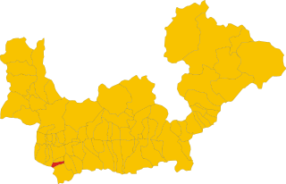
Rasura (Rasura)
- Italian comune
Rasura is a lesser-known but beautiful hiking destination located in the Lombardy region of northern Italy. It offers a unique combination of stunning landscapes, rich history, and cultural experiences. Here’s an overview of what you can expect when hiking in Rasura:
Scenery and Trails:
-
Diverse Terrain: Rasura is surrounded by the dramatic peaks of the Orobie Alps, providing a variety of hiking trails that cater to different skill levels. You can find everything from gentle walks to more challenging treks.
-
Natural Beauty: The area boasts lush forests, picturesque valleys, and stunning mountain views. Hikers can enjoy the peaceful ambiance of the Italian countryside, with opportunities to see local wildlife, wildflowers, and beautiful alpine lakes.
-
Popular Trails:
- Sentiero Dei Roni: A moderate trail that offers great views and is suitable for families.
- Via Alta delle Orobie: A more demanding trek that takes you through high-altitude landscapes, showcasing the best of the Orobie mountains.
Cultural and Historical Attractions:
-
Traditional Villages: While hiking, you may encounter small, charming villages and experience local culture, architecture, and cuisine. This can be a great opportunity to sample regional dishes and interact with local residents.
-
Historical Sites: Rasura is close to several historical sites, including ancient churches and medieval structures. Exploring these can add a rich cultural dimension to your hiking experience.
Practical Considerations:
-
Best Time to Visit: The hiking season generally runs from late spring to early autumn (May to October). Summer months are ideal for hiking, but be mindful of potentially crowded trails.
-
Safety Precautions: As with any hiking adventure, be well prepared. Bring adequate clothing, maps, and supplies, particularly since weather conditions in the mountains can change rapidly.
-
Guided Tours: If you're not familiar with the area, consider joining a guided hiking tour. Local guides can provide valuable insights about the geography, flora, and fauna, as well as ensure a safe experience.
Getting There:
Rasura is accessible by car or public transport from major cities like Milan. It might require some planning to reach trailheads, so it’s advisable to look into transportation options in advance.
Hiking in Rasura can be a rewarding experience, allowing you to connect with nature and immerse yourself in the beauty of the Italian Alps. Happy hiking!
- Country:

- Postal Code: 23010
- Local Dialing Code: 0342
- Licence Plate Code: SO
- Coordinates: 46° 6' 0" N, 9° 33' 0" E


- GPS tracks (wikiloc): [Link]
- AboveSeaLevel: 762 м m
- Area: 6 sq km
- Population: 291
- Web site: http://www.comune.rasura.so.it
- Wikipedia en: wiki(en)
- Wikipedia: wiki(it)
- Wikidata storage: Wikidata: Q39904
- Wikipedia Commons Category: [Link]
- Freebase ID: [/m/0gj3mh]
- GeoNames ID: Alt: [6537103]
- OSM relation ID: [46851]
- WOEID: [721527]
- ISTAT ID: 014055
- Italian cadastre code: H192
Shares border with regions:


Pedesina
- Italian comune
Pedesina is a small and picturesque village located in the Valtellina region of northern Italy, nestled in the Alps. It offers stunning natural beauty and a variety of hiking opportunities for outdoor enthusiasts. Here are some highlights for hiking in and around Pedesina:...
- Country:

- Postal Code: 23010
- Local Dialing Code: 0342
- Licence Plate Code: SO
- Coordinates: 46° 5' 0" N, 9° 33' 0" E


- GPS tracks (wikiloc): [Link]
- AboveSeaLevel: 1032 м m
- Area: 6.3 sq km
- Population: 41
- Web site: [Link]
Bema
- Italian comune
Bema, located in the Lombardy region of Italy, is a beautiful destination for hiking enthusiasts. Nestled in the mountainous area of the Valtellina valley, it offers stunning views, diverse landscapes, and rich flora and fauna. Here are some highlights and tips for hiking in Bema:...
- Country:

- Postal Code: 23010
- Local Dialing Code: 0342
- Licence Plate Code: SO
- Coordinates: 46° 7' 0" N, 9° 34' 0" E


- GPS tracks (wikiloc): [Link]
- AboveSeaLevel: 800 м m
- Area: 19.22 sq km
- Population: 116
- Web site: [Link]


Rogolo
- Italian comune
Hiking in Rogolo, a mountain located in the Lombardy region of northern Italy, offers stunning views and a range of trails suitable for different hiking abilities. The area is known for its beautiful landscapes, rich flora and fauna, and the nearby valleys and peaks of the Orobie Alps....
- Country:

- Postal Code: 23010
- Local Dialing Code: 0342
- Licence Plate Code: SO
- Coordinates: 46° 8' 8" N, 9° 29' 14" E


- GPS tracks (wikiloc): [Link]
- AboveSeaLevel: 216 м m
- Area: 12.83 sq km
- Population: 553
- Web site: [Link]
Cosio Valtellino
- Italian comune
Cosio Valtellino, located in the province of Sondrio in the Valtellina region of northern Italy, is a hidden gem for hikers and nature enthusiasts. This area offers a variety of trails that cater to different skill levels, showcasing stunning landscapes, rich flora and fauna, and traditional alpine culture....
- Country:

- Postal Code: 23013
- Local Dialing Code: 0342
- Licence Plate Code: SO
- Coordinates: 46° 8' 0" N, 9° 32' 0" E


- GPS tracks (wikiloc): [Link]
- AboveSeaLevel: 231 м m
- Area: 23.99 sq km
- Population: 5512
- Web site: [Link]

