Ratières (Ratières)

- commune in Drôme, France
 Hiking in Ratières
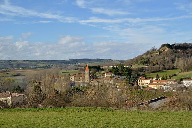
Ratières is a small village located in the Drôme department of the Auvergne-Rhône-Alpes region of France, not far from the Vercors Massif. It offers a peaceful environment surrounded by nature, making it an attractive spot for hiking enthusiasts. Here’s what you can expect when hiking in the area:
Scenery and Trails
- Diverse Landscapes: The region features a mix of rolling hills, forests, pastures, and stunning views of the Vercors mountains. The natural diversity allows for varied hiking experiences, from gentle walks to more challenging hikes.
- Wildlife and Flora: You may encounter various wildlife, including deer and numerous bird species, and you'll see a rich variety of plant life, particularly in the spring and summer.
Hiking Trails
- Local Trails: Ratières has access to several local hiking trails that are relatively less crowded, allowing for a more tranquil experience. Be sure to check local guides or apps for trail maps.
- Vercors Regional Natural Park: Just a short distance away, the park offers numerous well-marked trails ranging in difficulty. It's a great option for day trips with different landscapes and longer hikes.
Tips for Hiking in Ratières
- Seasonal Considerations: The best times to hike in this area are late spring through early fall. Winter hikes may require snow gear if trails are accessible.
- Safety: As with any hiking adventure, always check the weather and trail conditions before heading out. Carry sufficient water, snacks, and a first aid kit.
- Navigation: Use a map or a hiking app to navigate the trails. Some areas may not have extensive signage.
- Respect Nature: Follow Leave No Trace principles: stay on trails, pack out what you pack in, and respect wildlife.
- Local Resources: Consider visiting local tourism offices in nearby towns for maps, advice, and recommendations on the best trails suited to your skill level.
Conclusion
Hiking in Ratières can be a charming experience enveloped in nature, with options for both short walks and longer treks. Whether you are seeking solitude or a family-friendly adventure, this region has something to offer all hiking enthusiasts. Happy trekking!
- Country:

- Postal Code: 26330
- Coordinates: 45° 10' 54" N, 4° 58' 5" E


- GPS tracks (wikiloc): [Link]
- Area: 9.01 sq km
- Population: 268
- Wikipedia en: wiki(en)
- Wikipedia: wiki(fr)
- Wikidata storage: Wikidata: Q932251
- Wikipedia Commons Category: [Link]
- Freebase ID: [/m/03mhjcf]
- GeoNames ID: Alt: [6430184]
- SIREN number: [212602593]
- BnF ID: [15253119n]
- INSEE municipality code: 26259
Shares border with regions:


Saint-Donat-sur-l'Herbasse
- commune in Drôme, France
Hiking in Saint-Donat-sur-l'Herbasse
Saint-Donat-sur-l'Herbasse is a charming commune located in the Drôme department in the Auvergne-Rhône-Alpes region of southeastern France. While it may not be as famous as some of the larger hiking destinations, it offers beautiful landscapes and a variety of trails suitable for hikers of all levels....
- Country:
- Postal Code: 26260
- Coordinates: 45° 7' 23" N, 4° 58' 58" E
- GPS tracks (wikiloc): [Link]
- Area: 19.52 sq km
- Population: 4018


Bathernay
- commune in Drôme, France
Hiking in Bathernay
Bathernay is a charming commune in the Rhône department of France, nestled in the Auvergne-Rhône-Alpes region. While it may not be as widely known as some other hiking destinations, the surrounding areas offer beautiful landscapes and opportunities for outdoor exploration....
- Country:
- Postal Code: 26260
- Coordinates: 45° 10' 46" N, 4° 59' 39" E
- GPS tracks (wikiloc): [Link]
- Area: 5.71 sq km
- Population: 247


Bren
- commune in Drôme, France
Hiking in Bren
Bren is a charming commune located in the Drôme department in southeastern France, known for its stunning landscapes and outdoor activities, including hiking. The Drôme region offers a variety of hiking opportunities with diverse terrains, from gentle hills to more challenging trails through rugged scenery....
- Country:
- Postal Code: 26260
- Coordinates: 45° 8' 7" N, 4° 56' 54" E
- GPS tracks (wikiloc): [Link]
- Area: 11.03 sq km
- Population: 551


Saint-Avit
- commune in Drôme, France
Hiking in Saint-Avit
Saint-Avit, located in the Drôme department in southeastern France, offers a variety of hiking opportunities thanks to its stunning natural landscapes, rolling hills, and charming villages. The area is characterized by its diverse terrain, which includes vineyards, forests, and rocky outcrops, making it ideal for outdoor enthusiasts....
- Country:
- Postal Code: 26330
- Coordinates: 45° 11' 48" N, 4° 58' 11" E
- GPS tracks (wikiloc): [Link]
- Area: 8.94 sq km
- Population: 298
- Web site: [Link]
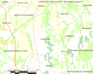
Claveyson
- commune in Drôme, France
Hiking in Claveyson
It seems there might be a misunderstanding with the name "Claveyson," as I couldn't find any specific hiking location by that name in my database. It’s possible you might be referring to a different area, or perhaps it’s a lesser-known trail or region....
- Country:
- Postal Code: 26240
- Coordinates: 45° 10' 50" N, 4° 55' 48" E
- GPS tracks (wikiloc): [Link]
- Area: 16.13 sq km
- Population: 877

Charmes-sur-l'Herbasse
- commune in Drôme, France
Hiking in Charmes-sur-l'Herbasse
Charmes-sur-l'Herbasse is a quaint village located in the Drôme department of southeastern France. It’s a wonderful location for hiking enthusiasts, offering a mix of beautiful landscapes, natural tranquility, and cultural sights. Here are some highlights for hiking in and around Charmes-sur-l'Herbasse:...
- Country:
- Postal Code: 26260
- Coordinates: 45° 8' 54" N, 5° 0' 58" E
- GPS tracks (wikiloc): [Link]
- Area: 12.84 sq km
- Population: 936