canton of Saint-Vallier (canton de Saint-Vallier)

- canton of France in Drôme
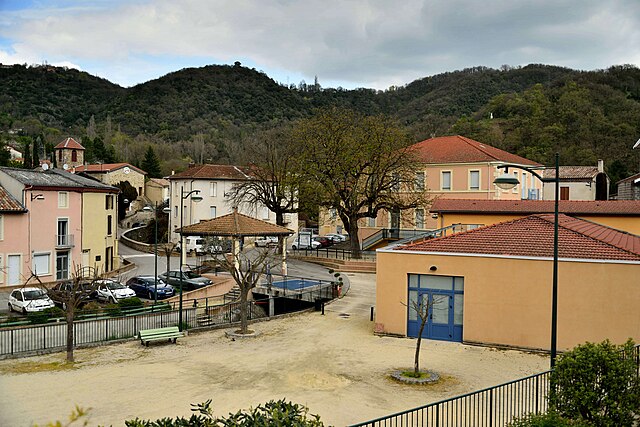
 Hiking in canton of Saint-Vallier
The Canton of Saint-Vallier, located in the Drôme department of France, offers a picturesque setting for hiking enthusiasts. This region is characterized by its rolling hills, vineyards, and charming villages, making it a great destination for both casual walkers and more experienced hikers.
Hiking Highlights in the Canton of Saint-Vallier:
-
Varied Terrain: The terrain in this area includes a mix of gentle slopes, vineyards, and wooded areas. This diversity allows for a range of trails suited to different skill levels.
-
Scenic Views: Many of the trails provide stunning views of the surrounding countryside, including the Rhône Valley and the mountains in the distance. Sunrise and sunset hikes can be particularly rewarding.
-
Cultural Exploration: While hiking, you can also discover local heritage, including traditional stone houses, chapels, and remnants of ancient agricultural practices. Some trails may lead through small villages where you can experience local culture and cuisine.
-
Local Vineyards: The Drôme department is known for its wine production. Hiking in the area provides opportunities to visit local vineyards and wineries, where you can learn about the wine-making process and sample regional wines.
-
Nature Reserves: There are nearby natural parks and reserves that enhance the hiking experience with opportunities to see local flora and fauna, including various bird species and native plants.
Recommended Tips:
-
Trail Maps: Before heading out, obtain a trail map or download hiking apps that provide GPS-based routes for the area to avoid getting lost.
-
Weather Preparedness: Always check the weather forecast before starting a hike and dress in layers, as conditions can change.
-
Hydration and Safety: Bring enough water, snacks, and a first-aid kit. It's important to stay hydrated, especially during warmer months.
-
Respect Nature: Follow Leave No Trace principles: pack out what you pack in, stay on marked trails, and be mindful of wildlife.
Notable Trails:
While specific trails can vary, look for local guides or signposts indicating popular routes in the area. Nearby hiking networks may offer organized hikes if you're interested in exploring with a group.
By exploring the Canton of Saint-Vallier on foot, you'll not only enjoy the physical activity but also the natural beauty and cultural richness of the Drôme region. Happy hiking!
- Country:

- Capital: Saint-Vallier
- Coordinates: 45° 10' 58" N, 4° 52' 39" E


- GPS tracks (wikiloc): [Link]
- Population: 26679
- Wikipedia en: wiki(en)
- Wikipedia: wiki(fr)
- Wikidata storage: Wikidata: Q747323
- INSEE canton code: [2612]
Includes regions:

Ponsas
- commune in Drôme, France
- Country:
- Postal Code: 26240
- Coordinates: 45° 9' 34" N, 4° 50' 14" E
- GPS tracks (wikiloc): [Link]
- Area: 2.71 sq km
- Population: 527

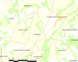
Mureils
- commune in Drôme, France
Hiking in Mureils
It seems like you might be referring to a specific area or hiking location, but "Mureils" doesn't appear to be a widely recognized hiking destination or location as of my last knowledge update in October 2023. It’s possible you meant a different location with a similar name or a less commonly known local site....
- Country:
- Postal Code: 26240
- Coordinates: 45° 12' 32" N, 4° 55' 48" E
- GPS tracks (wikiloc): [Link]
- Area: 5.45 sq km
- Population: 466


La Motte-de-Galaure
- commune in Drôme, France
Hiking in La Motte-de-Galaure
La Motte-de-Galaure is a charming village located in the Drôme department in the Auvergne-Rhône-Alpes region of southeastern France. This area is characterized by its rolling hills, vineyards, and stunning countryside, making it a great location for hiking enthusiasts....
- Country:
- Postal Code: 26240
- Coordinates: 45° 11' 48" N, 4° 54' 20" E
- GPS tracks (wikiloc): [Link]
- Area: 7.73 sq km
- Population: 786

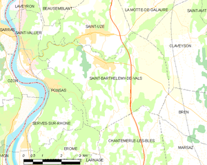
Saint-Barthélemy-de-Vals
- commune in Drôme, France
Hiking in Saint-Barthélemy-de-Vals
Saint-Barthélemy-de-Vals is a charming village located in the Auvergne-Rhône-Alpes region of France, known for its beautiful landscapes, rolling hills, and diverse natural scenery. While it may not be as famous as some hiking destinations, it offers a variety of trails suited to different skill levels, making it a lovely spot for outdoor enthusiasts....
- Country:
- Postal Code: 26240
- Coordinates: 45° 10' 9" N, 4° 52' 19" E
- GPS tracks (wikiloc): [Link]
- Area: 20.27 sq km
- Population: 1873

Saint-Rambert-d'Albon
- commune in Drôme, France
- Country:
- Postal Code: 26140
- Coordinates: 45° 17' 38" N, 4° 49' 1" E
- GPS tracks (wikiloc): [Link]
- Area: 13.41 sq km
- Population: 6313
- Web site: [Link]

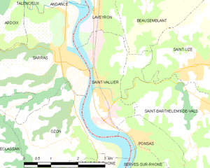
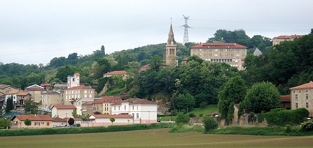
Saint-Vallier
- commune in Drôme, France
- Country:
- Postal Code: 26240
- Coordinates: 45° 10' 43" N, 4° 48' 55" E
- GPS tracks (wikiloc): [Link]
- Area: 5.42 sq km
- Population: 3935
- Web site: [Link]


Saint-Uze
- commune in Drôme, France
Hiking in Saint-Uze
Saint-Uze is a charming village located in the Auvergne-Rhône-Alpes region of France. While it may not be one of the most famous hiking destinations, it does offer opportunities for hiking and enjoying the surrounding natural beauty....
- Country:
- Postal Code: 26240
- Coordinates: 45° 11' 3" N, 4° 51' 40" E
- GPS tracks (wikiloc): [Link]
- Area: 10.1 sq km
- Population: 2025
- Web site: [Link]


Saint-Martin-d'Août
- commune in Drôme, France
Hiking in Saint-Martin-d'Août
Saint-Martin-d'Août is a beautiful location for hiking enthusiasts, situated in the Rhône-Alpes region of France. This village is surrounded by the stunning natural landscapes of the Vercors and the Drôme Provençale, offering a variety of hiking trails that cater to different skill levels....
- Country:
- Postal Code: 26330
- Coordinates: 45° 13' 3" N, 4° 59' 5" E
- GPS tracks (wikiloc): [Link]
- Area: 7.67 sq km
- Population: 381

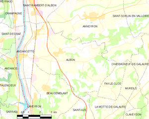
Albon
- commune in Drôme, France
- Country:
- Postal Code: 26140
- Coordinates: 45° 14' 44" N, 4° 50' 56" E
- GPS tracks (wikiloc): [Link]
- Area: 25.62 sq km
- Population: 1879


Andancette
- commune in Drôme, France
- Country:
- Postal Code: 26140
- Coordinates: 45° 14' 31" N, 4° 48' 25" E
- GPS tracks (wikiloc): [Link]
- Area: 5.98 sq km
- Population: 1344
- Web site: [Link]


Saint-Avit
- commune in Drôme, France
Hiking in Saint-Avit
Saint-Avit, located in the Drôme department in southeastern France, offers a variety of hiking opportunities thanks to its stunning natural landscapes, rolling hills, and charming villages. The area is characterized by its diverse terrain, which includes vineyards, forests, and rocky outcrops, making it ideal for outdoor enthusiasts....
- Country:
- Postal Code: 26330
- Coordinates: 45° 11' 48" N, 4° 58' 11" E
- GPS tracks (wikiloc): [Link]
- Area: 8.94 sq km
- Population: 298
- Web site: [Link]

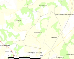
Fay-le-Clos
- commune in Drôme, France
Hiking in Fay-le-Clos
Fay-le-Clos is a charming destination situated in the scenic region of France, known for its natural beauty and peaceful landscapes. While it may not be as widely known as some other hiking spots, it offers a variety of opportunities for outdoor enthusiasts....
- Country:
- Postal Code: 26240
- Coordinates: 45° 12' 48" N, 4° 54' 21" E
- GPS tracks (wikiloc): [Link]
- Area: 4.56 sq km
- Population: 169
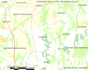
Claveyson
- commune in Drôme, France
Hiking in Claveyson
It seems there might be a misunderstanding with the name "Claveyson," as I couldn't find any specific hiking location by that name in my database. It’s possible you might be referring to a different area, or perhaps it’s a lesser-known trail or region....
- Country:
- Postal Code: 26240
- Coordinates: 45° 10' 50" N, 4° 55' 48" E
- GPS tracks (wikiloc): [Link]
- Area: 16.13 sq km
- Population: 877


Beausemblant
- commune in Drôme, France
- Country:
- Postal Code: 26240
- Coordinates: 45° 13' 1" N, 4° 49' 49" E
- GPS tracks (wikiloc): [Link]
- Area: 11.67 sq km
- Population: 1416

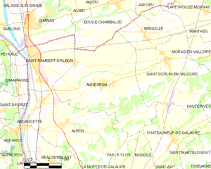
Anneyron
- commune in Drôme, France
Hiking in Anneyron
Anneyron is a charming town located in the Drôme department in southeastern France. Nestled in the Rhône Valley, it's a great starting point for exploring the surrounding natural landscapes. Here are some highlights and tips for hiking in and around Anneyron:...
- Country:
- Postal Code: 26140
- Coordinates: 45° 16' 16" N, 4° 53' 16" E
- GPS tracks (wikiloc): [Link]
- Area: 36.23 sq km
- Population: 3924
- Web site: [Link]

Châteauneuf-de-Galaure
- commune in Drôme, France
Hiking in Châteauneuf-de-Galaure
Châteauneuf-de-Galaure is a charming village located in the Auvergne-Rhône-Alpes region of France, known for its picturesque landscapes and access to hiking trails. Here are some points of interest for hiking in and around Châteauneuf-de-Galaure:...
- Country:
- Postal Code: 26330
- Coordinates: 45° 13' 55" N, 4° 57' 25" E
- GPS tracks (wikiloc): [Link]
- Area: 18.08 sq km
- Population: 1770


Ratières
- commune in Drôme, France
Hiking in Ratières
Ratières is a small village located in the Drôme department of the Auvergne-Rhône-Alpes region of France, not far from the Vercors Massif. It offers a peaceful environment surrounded by nature, making it an attractive spot for hiking enthusiasts. Here’s what you can expect when hiking in the area:...
- Country:
- Postal Code: 26330
- Coordinates: 45° 10' 54" N, 4° 58' 5" E
- GPS tracks (wikiloc): [Link]
- Area: 9.01 sq km
- Population: 268

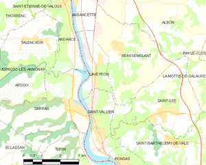
Laveyron
- commune in Drôme, France
- Country:
- Postal Code: 26240
- Coordinates: 45° 12' 0" N, 4° 48' 44" E
- GPS tracks (wikiloc): [Link]
- Area: 5.32 sq km
- Population: 1145