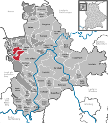
Rechtenbach (Rechtenbach)
- municipality of Germany
Rechtenbach is a charming area that offers various hiking opportunities, especially for those who enjoy nature and picturesque landscapes. While it might not be as widely known as some larger hiking destinations, its natural beauty is certainly worth exploring.
Hiking Trails
The region around Rechtenbach features a mix of trails suitable for all levels of hikers. Here are some general aspects to consider:
-
Difficulty Levels: You can find easy to moderate trails that are family-friendly, as well as more challenging routes for experienced hikers.
-
Scenic Views: Many trails offer breathtaking views of the surrounding countryside, including lush forests, hills, and river valleys. Wildlife sightings are also common.
-
Local Flora and Fauna: Hiking in Rechtenbach provides an opportunity to experience local biodiversity, including various plant species and potentially some wildlife, depending on the season.
-
Access to Nature: The trails often wind through woodlands and meadows, allowing for a peaceful hiking experience and a chance to connect with nature.
Practical Information
-
Maps and Guides: It’s advisable to carry a map or use a reliable mobile app for navigation. Local tourist information centers may have detailed maps and trail guides available.
-
Weather Considerations: The weather can change quickly, so it’s essential to dress in layers, wear suitable footwear, and carry rain gear if necessary.
-
Sustainability: Always follow Leave No Trace principles to keep the environment clean and preserve the natural beauty for future hikers.
Nearby Attractions
If you have time to explore beyond hiking, consider visiting nearby villages or natural parks that may offer additional recreational opportunities, cultural experiences, or historical landmarks.
Before setting out, it's wise to check the latest updates on trail conditions and any potential closures, especially if hiking during off-peak seasons. Enjoy your hiking adventure in Rechtenbach!
- Country:

- Postal Code: 97848
- Local Dialing Code: 09352
- Licence Plate Code: MSP
- Coordinates: 49° 59' 0" N, 9° 30' 0" E


- GPS tracks (wikiloc): [Link]
- AboveSeaLevel: 345 м m
- Area: 2.09 sq km
- Population: 1107
- Web site: https://www.rechtenbach-spessart.de/
- Wikipedia en: wiki(en)
- Wikipedia: wiki(de)
- Wikidata storage: Wikidata: Q508908
- Wikipedia Commons Category: [Link]
- Freebase ID: [/m/02q4jj8]
- GeoNames ID: Alt: [2849710]
- OSM relation ID: [337281]
- GND ID: Alt: [4231474-4]
- Bavarikon ID: [ODB_A00000451]
- German municipality key: 09677172
Shares border with regions:
Forst Lohrerstraße
- unincorporated area in Germany
Forst Lohrerstraße is located in the beautiful region of Bavaria, Germany. While it may not be as widely known as some of the larger national parks or hiking regions, it offers a scenic environment for outdoor enthusiasts. Here are some highlights and tips for hiking in and around Forst Lohrerstraße:...
- Country:

- Coordinates: 49° 58' 17" N, 9° 29' 4" E


- GPS tracks (wikiloc): [Link]


Partensteiner Forst
- unincorporated area in Germany
Partensteiner Forst, located in Bavaria, Germany, is a beautiful area for hiking, characterized by its dense forests, picturesque landscapes, and a variety of trails suitable for different skill levels. Here are some details to help you plan your hiking experience in this region:...
- Country:

- Coordinates: 50° 1' 8" N, 9° 28' 26" E


- GPS tracks (wikiloc): [Link]


Lohr am Main
- town in Bavaria, Germany
Lohr am Main, located in Bavaria, Germany, is a picturesque town that offers beautiful hiking opportunities amid stunning landscapes. The area surrounding Lohr is characterized by its scenic views of the Main River, lush forests, and rolling hills. Here are some highlights for hiking in and around Lohr am Main:...
- Country:

- Postal Code: 97816
- Local Dialing Code: 09352
- Licence Plate Code: MSP
- Coordinates: 49° 59' 37" N, 9° 34' 42" E


- GPS tracks (wikiloc): [Link]
- AboveSeaLevel: 167 м m
- Area: 90.44 sq km
- Population: 15719
- Web site: [Link]

