Regalbuto (Regalbuto)
.svg)
- Italian comune
 Hiking in Regalbuto
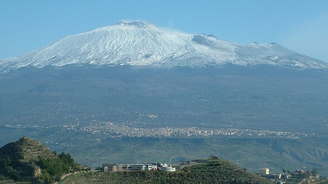
Regalbuto is a charming town located in the heart of Sicily, Italy, known for its beautiful landscapes and rich history. Hiking in and around Regalbuto can offer a variety of experiences, from scenic views to cultural encounters.
Hiking Trails and Areas
-
Sicilian Hills: The surrounding hills of Regalbuto provide numerous trails that vary in difficulty. You'll find paths that offer expansive views of the Sicilian countryside, dotted with olive groves, vineyards, and traditional farms.
-
Lago di Pozzillo: This lake is located a short distance from Regalbuto and provides opportunities for hiking along its shores, offering picturesque views and a chance to enjoy the local flora and fauna.
-
Nature Reserves: The area is near the Nebrodi or Etna Regional Parks, where you can find various trails catering to different skill levels. These parks are filled with unique wildlife and diverse ecosystems.
-
Historical Paths: Some trails lead to historical sites like ancient ruins or old monasteries, where you can combine hiking with a bit of cultural exploration.
Tips for Hiking in Regalbuto
- Check the Weather: Sicilian weather can be quite hot in summer; early mornings or later afternoons are the best times to hike.
- Wear Proper Gear: Good hiking boots and appropriate clothing for the season are essential.
- Stay Hydrated: Carry enough water, especially during warmer months.
- Local Guidance: If you’re unfamiliar with the area, consider hiring a local guide who can provide insights into the trails and help ensure your safety.
- Respect the Environment: Stick to marked trails, and carry your trash out with you to preserve the natural beauty of the area.
Local Culture
While hiking, take the opportunity to interact with locals. Regalbuto has a strong agricultural heritage, and you may encounter traditional farming practices and local crafts.
Conclusion
Hiking in Regalbuto allows you to experience the natural beauty of Sicily while also exploring its rich cultural heritage. Whether you're an experienced hiker or a casual walker, you'll find plenty to enjoy in this picturesque town and its surroundings.
- Country:

- Postal Code: 94017
- Local Dialing Code: 0935
- Licence Plate Code: EN
- Coordinates: 37° 39' 0" N, 14° 38' 0" E


- GPS tracks (wikiloc): [Link]
- AboveSeaLevel: 520 м m
- Area: 170.29 sq km
- Population: 7190
- Web site: http://www.comune.regalbuto.en.it
- Wikipedia en: wiki(en)
- Wikipedia: wiki(it)
- Wikidata storage: Wikidata: Q56210
- Wikipedia Commons Gallery: [Link]
- Wikipedia Commons Category: [Link]
- Freebase ID: [/m/0fcqj_]
- GeoNames ID: Alt: [6537798]
- VIAF ID: Alt: [242328697]
- OSM relation ID: [39293]
- GND ID: Alt: [7585741-8]
- Library of Congress authority ID: Alt: [n2005010345]
- WOEID: [721563]
- TGN ID: [1046254]
- ISTAT ID: 086016
- Italian cadastre code: H221
Shares border with regions:
Adrano
- Italian comune
Hiking in Adrano
Adrano is a charming town located in Sicily, Italy, and is surrounded by the beautiful landscapes of Mount Etna and the Sicilian countryside. Hiking in and around Adrano offers a mix of natural beauty, historical sites, and diverse trails suitable for all skill levels....
- Country:
- Postal Code: 95031
- Local Dialing Code: 095
- Licence Plate Code: CT
- Coordinates: 37° 39' 45" N, 14° 50' 8" E
- GPS tracks (wikiloc): [Link]
- AboveSeaLevel: 560 м m
- Area: 83.22 sq km
- Population: 35633
- Web site: [Link]

Randazzo
- Italian comune
Hiking in Randazzo
Randazzo is a charming town located in Sicily, Italy, nestled at the foot of Mount Etna. It offers a variety of hiking opportunities that cater to different skill levels, allowing hikers to explore beautiful landscapes, historical sites, and the stunning natural scenery of the region....
- Country:
- Postal Code: 95036
- Local Dialing Code: 095
- Licence Plate Code: CT
- Coordinates: 37° 53' 0" N, 14° 57' 0" E
- GPS tracks (wikiloc): [Link]
- AboveSeaLevel: 765 м m
- Area: 205.62 sq km
- Population: 10763
- Web site: [Link]

Agira
- Italian comune
Hiking in Agira
Agira, a charming town in the province of Enna in Sicily, Italy, offers a range of hiking opportunities that blend natural beauty with rich cultural heritage. The area boasts stunning landscapes, with rolling hills, rocky terrains, and panoramic views of the surrounding countryside....
- Country:
- Postal Code: 94011
- Local Dialing Code: 0935
- Licence Plate Code: EN
- Coordinates: 37° 39' 0" N, 14° 31' 0" E
- GPS tracks (wikiloc): [Link]
- AboveSeaLevel: 650 м m
- Area: 164.08 sq km
- Population: 8222
- Web site: [Link]

Catenanuova
- Italian comune
Hiking in Catenanuova
Catenanuova is a small town in Sicily, Italy, surrounded by beautiful landscapes that offer potential for hiking and outdoor activities. While the town itself may not be a well-known hiking destination, the surrounding areas provide opportunities for exploration....
- Country:
- Postal Code: 94010
- Local Dialing Code: 0935
- Licence Plate Code: EN
- Coordinates: 37° 34' 0" N, 14° 41' 0" E
- GPS tracks (wikiloc): [Link]
- AboveSeaLevel: 170 м m
- Area: 11.22 sq km
- Population: 4798
- Web site: [Link]

Centuripe
- Italian comune
Hiking in Centuripe
Centuripe is a charming town located in the heart of Sicily, Italy, known for its rich history, archaeological significance, and stunning landscapes. Hiking in and around Centuripe can offer a unique experience, blending natural beauty with cultural heritage. Here are some key points about hiking in the area:...
- Country:
- Postal Code: 94010
- Local Dialing Code: 0935
- Licence Plate Code: EN
- Coordinates: 37° 37' 24" N, 14° 44' 22" E
- GPS tracks (wikiloc): [Link]
- AboveSeaLevel: 730 м m
- Area: 174.2 sq km
- Population: 5373
- Web site: [Link]

Gagliano Castelferrato
- Italian comune
Hiking in Gagliano Castelferrato
Gagliano Castelferrato is a charming town located in the province of Enna, Sicily, Italy. The area is not only rich in history and culture but is also surrounded by stunning natural landscapes, making it an excellent location for hiking enthusiasts. Here’s what you can expect when hiking in and around Gagliano Castelferrato:...
- Country:
- Postal Code: 94010
- Local Dialing Code: 0935
- Licence Plate Code: EN
- Coordinates: 37° 43' 0" N, 14° 32' 0" E
- GPS tracks (wikiloc): [Link]
- AboveSeaLevel: 651 м m
- Area: 56.24 sq km
- Population: 3532
- Web site: [Link]

Troina
- Italian comune
Hiking in Troina
Troina, a charming town in the province of Enna in Sicily, Italy, is surrounded by beautiful landscapes, making it an excellent destination for hiking enthusiasts. Here are some key highlights about hiking in and around Troina:...
- Country:
- Postal Code: 94018
- Local Dialing Code: 0935
- Licence Plate Code: EN
- Coordinates: 37° 47' 0" N, 14° 36' 0" E
- GPS tracks (wikiloc): [Link]
- AboveSeaLevel: 1121 м m
- Area: 168.28 sq km
- Population: 9202
- Web site: [Link]