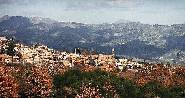
Adrano (Adrano)
.svg)
- Italian comune
 Hiking in Adrano
Adrano is a charming town located in Sicily, Italy, and is surrounded by the beautiful landscapes of Mount Etna and the Sicilian countryside. Hiking in and around Adrano offers a mix of natural beauty, historical sites, and diverse trails suitable for all skill levels.
Hiking Opportunities:
-
Mount Etna:
- As one of the most famous volcanoes in the world, Mount Etna offers numerous hiking routes. The trails vary from easy walks to challenging hikes, allowing you to explore craters, lava fields, and breathtaking views of the surrounding areas.
- Guided tours are available, and it’s advisable to check for volcanic activity before heading out, as routes can be affected by eruptions or other volcanic occurrences.
-
Parco dell'Etna:
- The park encompasses a wide range of trails that allow hikers to experience the unique flora and fauna of the region. Trails in the park may lead you through forests, vineyards, and vineyards, with stunning panoramas of the volcano and the Ionian Sea.
-
Historical Hiking Trails:
- There are several paths that connect Adrano to nearby historical sites such as ancient castles, ruins, and old churches. These trails often offer a chance to explore the rich history of the area while enjoying nature.
-
Natural Reserves:
- The surrounding areas include natural reserves that feature trails through varied terrains, from mountainous regions to valleys. These can provide a more tranquil hiking experience with opportunities for wildlife spotting.
Tips for Hiking in Adrano:
- Gear: Wear sturdy hiking boots and dress in layers, as temperatures can change rapidly in the mountains.
- Hydration: Always carry enough water, especially when hiking on warmer days.
- Navigation: While many trails are marked, having a map or a GPS device can be helpful to navigate less defined paths.
- Safety: Inform someone about your hiking plans, and be aware of the weather conditions, particularly when hiking around Mount Etna.
Best Time to Hike:
The best time for hiking in Adrano is during the spring (March to May) and fall (September to November) when the weather is mild, and the trails are less crowded. Summer months can be hot, especially at lower elevations, while winter can bring snow to higher altitudes on Etna.
Conclusion:
Hiking in Adrano provides a unique blend of natural beauty, adventure, and cultural exploration. Whether you're a novice or an experienced hiker, the trails around this stunning Sicilian town are sure to offer a rewarding outdoor experience. Be sure to take the time to enjoy the gorgeous landscapes and the rich history of the area!
- Country:

- Postal Code: 95031
- Local Dialing Code: 095
- Licence Plate Code: CT
- Coordinates: 37° 39' 45" N, 14° 50' 8" E


- GPS tracks (wikiloc): [Link]
- AboveSeaLevel: 560 м m
- Area: 83.22 sq km
- Population: 35633
- Web site: http://www.comune.adrano.ct.it/
- Wikipedia en: wiki(en)
- Wikipedia: wiki(it)
- Wikidata storage: Wikidata: Q366574
- Wikipedia Commons Gallery: [Link]
- Wikipedia Commons Category: [Link]
- Freebase ID: [/m/0713j8]
- GeoNames ID: Alt: [6537804]
- VIAF ID: Alt: [243499853]
- OSM relation ID: [39338]
- GND ID: Alt: [4212124-3]
- Quora topic ID: [Adrano]
- UN/LOCODE: [ITZCF]
- Encyclopædia Britannica Online ID: [place/Adrano]
- Gran Enciclopèdia Catalana ID: [0000795]
- ISTAT ID: 087006
- Italian cadastre code: A056
Shares border with regions:

Zafferana Etnea
- Italian comune
Hiking in Zafferana Etnea
Zafferana Etnea, located on the eastern slope of Mount Etna in Sicily, Italy, is a beautiful destination for hiking enthusiasts. The region is renowned for its stunning landscapes, rich biodiversity, and unique volcanic terrain. Here are some highlights and tips for hiking in Zafferana Etnea:...
- Country:
- Postal Code: 95019
- Local Dialing Code: 095
- Licence Plate Code: CT
- Coordinates: 37° 41' 0" N, 15° 6' 0" E
- GPS tracks (wikiloc): [Link]
- AboveSeaLevel: 574 м m
- Area: 76.87 sq km
- Population: 9607
- Web site: [Link]
Belpasso
- Italian comune
Hiking in Belpasso
Belpasso, located on the eastern slope of Mount Etna in Sicily, Italy, offers a variety of hiking opportunities that combine stunning natural landscapes, fascinating geological features, and rich local history. Here are some key aspects to consider for a hiking experience in Belpasso:...
- Country:
- Postal Code: 95032
- Local Dialing Code: 095
- Licence Plate Code: CT
- Coordinates: 37° 35' 0" N, 14° 59' 0" E
- GPS tracks (wikiloc): [Link]
- AboveSeaLevel: 551 м m
- Area: 166.33 sq km
- Population: 28126
- Web site: [Link]

Biancavilla
- Italian comune
Hiking in Biancavilla
Biancavilla is a charming town located in the Sicilian region of Italy, nestled on the slopes of Mount Etna, Europe's highest and most active volcano. The surrounding area offers a diverse range of hiking opportunities suitable for various skill levels, with stunning landscapes, rich biodiversity, and unique geological features. Here’s an overview of what you can expect when hiking in Biancavilla:...
- Country:
- Postal Code: 95033
- Local Dialing Code: 095
- Licence Plate Code: CT
- Coordinates: 37° 38' 43" N, 14° 51' 49" E
- GPS tracks (wikiloc): [Link]
- AboveSeaLevel: 513 м m
- Area: 70.28 sq km
- Population: 23948
- Web site: [Link]
Bronte, Sicily
- Italian comune
Hiking in Bronte, Sicily
Bronte, a charming town located in Sicily, Italy, is surrounded by stunning landscapes that are perfect for hiking enthusiasts. Known for its pistachio production, Bronte is situated on the slopes of Mount Etna, one of the most active volcanoes in the world, which offers numerous trails and opportunities for exploration....
- Country:
- Postal Code: 95034
- Local Dialing Code: 095
- Licence Plate Code: CT
- Coordinates: 37° 48' 0" N, 14° 50' 0" E
- GPS tracks (wikiloc): [Link]
- AboveSeaLevel: 760 м m
- Area: 250.86 sq km
- Population: 18963
- Web site: [Link]

Castiglione di Sicilia
- Italian comune
Hiking in Castiglione di Sicilia
Castiglione di Sicilia, located in the Etna region of Sicily, is a delightful destination for hiking enthusiasts. Situated on a hillside overlooking the Alcantara River, this charming medieval town offers breathtaking views and access to a variety of trails that cater to different skill levels. Here are some highlights of hiking in and around Castiglione di Sicilia:...
- Country:
- Postal Code: 95012
- Local Dialing Code: 0942
- Licence Plate Code: CT
- Coordinates: 37° 52' 58" N, 15° 7' 21" E
- GPS tracks (wikiloc): [Link]
- AboveSeaLevel: 621 м m
- Area: 118.9 sq km
- Population: 3129
- Web site: [Link]

Maletto
- Italian comune
Hiking in Maletto
Maletto is a charming town located in the province of Catania in Sicily, Italy. Its position in the Nebrodi National Park makes it a wonderful destination for hiking enthusiasts. Here are some highlights about hiking in and around Maletto:...
- Country:
- Postal Code: 95035
- Local Dialing Code: 095
- Licence Plate Code: CT
- Coordinates: 37° 50' 0" N, 14° 52' 0" E
- GPS tracks (wikiloc): [Link]
- AboveSeaLevel: 960 м m
- Area: 40.96 sq km
- Population: 3818
- Web site: [Link]

Nicolosi
- Italian comune
Hiking in Nicolosi
Nicolosi, located on the eastern slopes of Mount Etna in Sicily, Italy, is a fantastic destination for hiking enthusiasts. The area offers a variety of trails set against a stunning backdrop of volcanic landscapes, lush forests, and panoramic views of the surrounding region....
- Country:
- Postal Code: 95030
- Local Dialing Code: 095
- Licence Plate Code: CT
- Coordinates: 37° 37' 0" N, 15° 1' 0" E
- GPS tracks (wikiloc): [Link]
- AboveSeaLevel: 700 м m
- Area: 42.65 sq km
- Population: 7528
- Web site: [Link]

Randazzo
- Italian comune
Hiking in Randazzo
Randazzo is a charming town located in Sicily, Italy, nestled at the foot of Mount Etna. It offers a variety of hiking opportunities that cater to different skill levels, allowing hikers to explore beautiful landscapes, historical sites, and the stunning natural scenery of the region....
- Country:
- Postal Code: 95036
- Local Dialing Code: 095
- Licence Plate Code: CT
- Coordinates: 37° 53' 0" N, 14° 57' 0" E
- GPS tracks (wikiloc): [Link]
- AboveSeaLevel: 765 м m
- Area: 205.62 sq km
- Population: 10763
- Web site: [Link]
Sant'Alfio
- Italian comune
Hiking in Sant'Alfio
Sant'Alfio is a charming town located on the eastern side of Sicily, Italy, known for its beautiful landscapes, rich history, and proximity to Mount Etna. When it comes to hiking in Sant'Alfio, there are several options that allow you to explore the stunning natural surroundings....
- Country:
- Postal Code: 95010
- Local Dialing Code: 095
- Licence Plate Code: CT
- Coordinates: 37° 45' 0" N, 15° 8' 0" E
- GPS tracks (wikiloc): [Link]
- AboveSeaLevel: 531 м m
- Area: 25.86 sq km
- Population: 1563
- Web site: [Link]

Centuripe
- Italian comune
Hiking in Centuripe
Centuripe is a charming town located in the heart of Sicily, Italy, known for its rich history, archaeological significance, and stunning landscapes. Hiking in and around Centuripe can offer a unique experience, blending natural beauty with cultural heritage. Here are some key points about hiking in the area:...
- Country:
- Postal Code: 94010
- Local Dialing Code: 0935
- Licence Plate Code: EN
- Coordinates: 37° 37' 24" N, 14° 44' 22" E
- GPS tracks (wikiloc): [Link]
- AboveSeaLevel: 730 м m
- Area: 174.2 sq km
- Population: 5373
- Web site: [Link]

Regalbuto
- Italian comune
Hiking in Regalbuto
Regalbuto is a charming town located in the heart of Sicily, Italy, known for its beautiful landscapes and rich history. Hiking in and around Regalbuto can offer a variety of experiences, from scenic views to cultural encounters....
- Country:
- Postal Code: 94017
- Local Dialing Code: 0935
- Licence Plate Code: EN
- Coordinates: 37° 39' 0" N, 14° 38' 0" E
- GPS tracks (wikiloc): [Link]
- AboveSeaLevel: 520 м m
- Area: 170.29 sq km
- Population: 7190
- Web site: [Link]