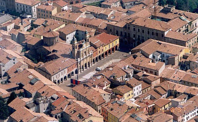
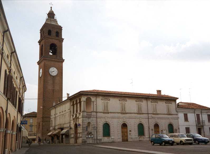
Reggiolo (Reggiolo)
.svg)
- town in the Italian province of Reggio Emilia
 Hiking in Reggiolo
Reggiolo, located in the Emilia-Romagna region of Italy, is not traditionally known as a hiking destination since it is a small town primarily surrounded by agricultural landscapes. However, the surrounding countryside offers some opportunities for walking and enjoying nature.
Hiking Opportunities Near Reggiolo
-
Countryside Trails: You can explore the flat agricultural fields and picturesque rural paths. These trails are typically not maintained as formal hiking routes but provide a chance to enjoy the serene landscape, especially during the spring and fall when the scenery is most vibrant.
-
Po River Park (Parco del Delta del Po): A bit further to the east from Reggiolo, the Po River Park offers numerous biking and walking trails along the river. The park features unique flora and fauna, making it a great spot for nature lovers.
-
Local Parks and Natural Reserves: There may be small parks or nature reserves in the area where you can enjoy short hikes. These tend to be more focused on leisurely walks rather than strenuous hiking.
-
Nearby Hills: If you’re willing to drive a little, heading towards the Apennine Mountains offers more traditional hiking opportunities. Locations like Monte Cimino, Monte Moria, or the trails around Modena provide a variety of hiking experiences ranging from easy trails to more challenging hikes.
Tips for Hiking Around Reggiolo
- Prepare for Weather: The weather can vary, so make sure to dress in layers and check forecasts before heading out.
- Local Maps: Consider obtaining a local map or guidebook for the area. Although trails may not be well-marked, a map can help you navigate.
- Hydration and Snacks: Always bring enough water and snacks, especially if you plan to hike longer distances.
- Wildlife Awareness: Be mindful of local wildlife and respect their habitat.
Overall, while Reggiolo may not be a premier hiking destination, its rural surroundings offer opportunities for leisurely walks. If you are an avid hiker, you may want to explore the more mountainous regions nearby for a greater variety of trails and scenic views.
- Country:

- Postal Code: 42046
- Local Dialing Code: 0522
- Licence Plate Code: RE
- Coordinates: 44° 55' 0" N, 10° 49' 0" E


- GPS tracks (wikiloc): [Link]
- AboveSeaLevel: 20 м m
- Area: 42.68 sq km
- Population: 9110
- Web site: http://www.comune.reggiolo.re.it/
- Wikipedia en: wiki(en)
- Wikipedia: wiki(it)
- Wikidata storage: Wikidata: Q952
- Wikipedia Commons Category: [Link]
- Freebase ID: [/m/0f2l0v]
- GeoNames ID: Alt: [6536721]
- VIAF ID: Alt: [167696762]
- OSM relation ID: [43780]
- MusicBrainz area ID: [2829be4c-2cc2-4cab-8cda-02a857d6c878]
- WOEID: [721569]
- Quora topic ID: [Reggiolo]
- TGN ID: [1046258]
- UN/LOCODE: [ITRGO]
- ISTAT ID: 035032
- Italian cadastre code: H225
Shares border with regions:
Campagnola Emilia
- Italian comune
Hiking in Campagnola Emilia
Campagnola Emilia is a charming town located in the Emilia-Romagna region of Italy, known for its rich agricultural landscape and beautiful countryside. Hiking in this area can be a delightful experience, as you’ll find rolling hills, vineyards, and historic sites to explore....
- Country:
- Postal Code: 42012
- Local Dialing Code: 0522
- Licence Plate Code: RE
- Coordinates: 44° 50' 10" N, 10° 45' 17" E
- GPS tracks (wikiloc): [Link]
- AboveSeaLevel: 22 м m
- Area: 24.39 sq km
- Population: 5639
- Web site: [Link]


Fabbrico
- Italian comune
Hiking in Fabbrico
Fabbrico is a small town in the Emilia-Romagna region of Italy, located in the province of Reggio Emilia. While it may not be widely recognized as a major hiking destination, the surrounding region offers some charming opportunities for hiking and outdoor activities. Here are some highlights and tips for hiking around Fabbrico:...
- Country:
- Postal Code: 42042
- Local Dialing Code: 0522
- Licence Plate Code: RE
- Coordinates: 44° 52' 0" N, 10° 48' 0" E
- GPS tracks (wikiloc): [Link]
- AboveSeaLevel: 25 м m
- Area: 23.63 sq km
- Population: 6609
- Web site: [Link]

Guastalla
- Italian comune
Hiking in Guastalla
Guastalla is a charming town located in the Emilia-Romagna region of Italy, known for its historical significance and beautiful landscapes along the Po River. While Guastalla itself is not a major hiking destination, there are several opportunities for hiking and enjoying nature in and around the area....
- Country:
- Postal Code: 42016
- Local Dialing Code: 0522
- Licence Plate Code: RE
- Coordinates: 44° 55' 17" N, 10° 39' 15" E
- GPS tracks (wikiloc): [Link]
- AboveSeaLevel: 24 м m
- Area: 52.93 sq km
- Population: 15032
- Web site: [Link]


Novellara
- Italian comune
Hiking in Novellara
Novellara is a charming town located in the Reggio Emilia region of Italy. While it may not be a major hiking destination like some of Italy's more mountainous areas, it offers some beautiful landscapes and routes that are suitable for walking and hiking enthusiasts....
- Country:
- Postal Code: 42017
- Local Dialing Code: 0522
- Licence Plate Code: RE
- Coordinates: 44° 51' 0" N, 10° 44' 0" E
- GPS tracks (wikiloc): [Link]
- AboveSeaLevel: 24 м m
- Area: 58.11 sq km
- Population: 13721
- Web site: [Link]


Rolo
- Italian comune
Hiking in Rolo
Rolo, located in the province of Reggio Emilia in the Emilia-Romagna region of Italy, is surrounded by picturesque landscapes and offers opportunities for outdoor activities, including hiking. While it may not be as well-known as other hiking destinations in the region, the area boasts beautiful countryside, rolling hills, and charming villages, making it ideal for scenic walks and exploratory hikes....
- Country:
- Postal Code: 42047
- Local Dialing Code: 0522
- Licence Plate Code: RE
- Coordinates: 44° 53' 0" N, 10° 51' 0" E
- GPS tracks (wikiloc): [Link]
- AboveSeaLevel: 21 м m
- Area: 14.17 sq km
- Population: 4062
- Web site: [Link]


Gonzaga
- Italian comune
Hiking in Gonzaga
Gonzaga, located in the Lombardy region of northern Italy, is not as widely recognized for hiking as some of the more mountainous areas in the region, such as the Alps or the Apennines. However, it does have its own charm and offers a variety of outdoor activities, including hiking....
- Country:
- Postal Code: 46023
- Local Dialing Code: 0376
- Licence Plate Code: MN
- Coordinates: 44° 57' 0" N, 10° 49' 0" E
- GPS tracks (wikiloc): [Link]
- AboveSeaLevel: 22 м m
- Area: 49.89 sq km
- Population: 9103
- Web site: [Link]


Moglia
- Italian comune
Hiking in Moglia
Moglia is a small town located in the Lombardy region of northern Italy, surrounded by beautiful landscapes that can be ideal for hiking. While it may not have extensive or famous hiking trails like those found in the Dolomites or the Aosta Valley, the surrounding countryside features rolling hills, vineyards, and farmland, which can provide a serene hiking experience....
- Country:
- Postal Code: 46024
- Local Dialing Code: 0376
- Licence Plate Code: MN
- Coordinates: 44° 56' 0" N, 10° 55' 0" E
- GPS tracks (wikiloc): [Link]
- AboveSeaLevel: 20 м m
- Area: 31.85 sq km
- Population: 5487
- Web site: [Link]

Luzzara
- Italian comune
Hiking in Luzzara
Luzzara is a charming town located in the Emilia-Romagna region of Italy, known for its picturesque landscape, historic architecture, and the beautiful Po River nearby. While Luzzara itself may not be a widely recognized hiking destination, the surrounding area offers opportunities for outdoor activities, including hiking trails that allow you to explore the natural beauty of the region....
- Country:
- Postal Code: 42045
- Local Dialing Code: 0522
- Licence Plate Code: RE
- Coordinates: 44° 58' 0" N, 10° 41' 0" E
- GPS tracks (wikiloc): [Link]
- AboveSeaLevel: 15 м m
- Area: 38.54 sq km
- Population: 8962
- Web site: [Link]