Rehetobel (Rehetobel)
- municipality in Switzerland
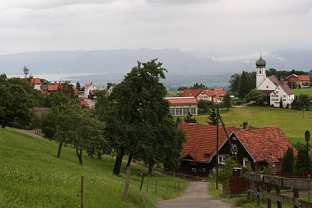
Rehetobel is a scenic area located in the canton of Appenzell in Switzerland, known for its picturesque landscapes and hiking opportunities. Here are some highlights and tips for hiking in Rehetobel:
Scenic Trails
- Nature Trails: Rehetobel offers a variety of marked nature trails that wind through lush meadows, forests, and offer stunning views of the Appenzell region and the surrounding Alps.
- Panoramic Views: Many trails lead to viewpoints that provide breathtaking panoramas of the Appenzellerland and neighboring regions. Don't forget your camera!
Popular Hikes
- Rehetobel to Appenzell: A relatively moderate hike that transitions through beautiful landscapes, allowing you to experience the charm of both Rehetobel and the iconic town of Appenzell.
- Höhenweg Trail: This path offers an easy hike with an elevation gain that’s manageable for most hikers, featuring a mix of forested areas and open pastures.
Hiking Tips
- Duration: Most hikes in the area can range from 1 to 5 hours, so plan according to your fitness level and experience.
- Weather Preparation: The weather in the Appenzell region can change rapidly, so it's advisable to bring layers and be prepared for rain.
- Footwear: Good hiking boots are essential for tackling varied terrain and ensuring stability.
- Navigation: While many trails are well-marked, carrying a map or GPS device can be very helpful, as signal may be sporadic in remote areas.
Local Amenities
- Public Transport: Rehetobel is accessible by public transport, making it easier to reach starting points of various trails without needing a car.
- Accommodations: There are several cozy accommodations available in the area, ranging from guesthouses to hotels, providing a comfortable place to rest after a day of hiking.
Other Activities
In addition to hiking, Rehetobel is great for biking and has areas suitable for picnics, offering ample opportunities to relax and enjoy the natural beauty around you.
Whether you're a seasoned hiker or looking for a leisurely stroll, Rehetobel's trails provide something for everyone amidst Switzerland's stunning landscapes. Just remember to respect nature, keep the trails clean, and enjoy your adventure!
- Country:

- Postal Code: 9038
- Local Dialing Code: 071
- Licence Plate Code: AR
- Coordinates: 47° 25' 40" N, 9° 28' 54" E


- GPS tracks (wikiloc): [Link]
- AboveSeaLevel: 940 м m
- Area: 6.72 sq km
- Population: 1750
- Web site: http://www.rehetobel.ch
- Wikipedia en: wiki(en)
- Wikipedia: wiki(de)
- Wikidata storage: Wikidata: Q67182
- Wikipedia Commons Category: [Link]
- Freebase ID: [/m/01v6cc]
- GeoNames ID: Alt: [7286871]
- VIAF ID: Alt: [242740355]
- OSM relation ID: [1683923]
- HDS ID: [1308]
- Swiss municipality code: [3034]
Shares border with regions:


Eggersriet
- municipality in Switzerland
Eggersriet is a charming little town located in the canton of St. Gallen, Switzerland, nestled amidst beautiful landscapes. Hiking in and around Eggersriet allows you to enjoy breathtaking views of the surrounding hills, forests, and rural scenery....
- Country:

- Postal Code: 9034
- Local Dialing Code: 071
- Licence Plate Code: SG
- Coordinates: 47° 26' 59" N, 9° 27' 59" E


- GPS tracks (wikiloc): [Link]
- AboveSeaLevel: 817 м m
- Area: 8.82 sq km
- Population: 2275
- Web site: [Link]


Speicher
- municipality in Switzerland
Speicher, located in the Appenzell Region of Switzerland, is an ideal destination for hiking enthusiasts. The area offers a picturesque blend of meadows, forests, and stunning mountain views. Here are some key highlights of hiking in Speicher:...
- Country:

- Postal Code: 9042
- Local Dialing Code: 071
- Licence Plate Code: AR
- Coordinates: 47° 24' 38" N, 9° 26' 36" E


- GPS tracks (wikiloc): [Link]
- AboveSeaLevel: 936 м m
- Area: 8.17 sq km
- Population: 4293
- Web site: [Link]


Wald
- municipality in the canton Appenzell Ausserrhoden, Switzerland
Wald, located in the Appenzell Ausserrhoden region of Switzerland, offers beautiful hiking opportunities amidst stunning natural landscapes. The area is characterized by rolling hills, vibrant meadows, and picturesque views of the nearby mountains, making it a fantastic destination for both casual walkers and seasoned hikers....
- Country:

- Postal Code: 9044
- Local Dialing Code: 071
- Licence Plate Code: AR
- Coordinates: 47° 24' 56" N, 9° 29' 25" E


- GPS tracks (wikiloc): [Link]
- AboveSeaLevel: 962 м m
- Area: 6.82 sq km
- Population: 857
- Web site: [Link]


Grub
- municipality in Switzerland
Grub, located in the Appenzell Ausserrhoden region of Switzerland, is known for its stunning scenic beauty and a variety of hiking trails that cater to different skill levels. Here’s a brief overview of what you can expect when hiking in this beautiful area:...
- Country:

- Postal Code: 9035
- Local Dialing Code: 071
- Licence Plate Code: AR
- Coordinates: 47° 26' 53" N, 9° 30' 34" E


- GPS tracks (wikiloc): [Link]
- AboveSeaLevel: 986 м m
- Area: 4.22 sq km
- Population: 1045
- Web site: [Link]


Trogen
- municipality in Switzerland
Trogen is a charming village located in the Appenzell region of Switzerland, surrounded by beautiful landscapes, rolling hills, and stunning views of the Alps. The area is known for its varied hiking trails that cater to all levels of experience, making it an excellent destination for both novice and experienced hikers....
- Country:

- Postal Code: 9043
- Local Dialing Code: 071
- Licence Plate Code: AR
- Coordinates: 47° 24' 27" N, 9° 27' 53" E


- GPS tracks (wikiloc): [Link]
- AboveSeaLevel: 903 м m
- Area: 10.02 sq km
- Population: 1721
- Web site: [Link]


Heiden
- municipality in Switzerland
Heiden is a picturesque village located in the Appenzell region of Switzerland, known for its stunning views of Lake Constance and its surrounding mountains. Hiking in and around Heiden offers a range of scenic trails suitable for different skill levels, making it a delightful destination for outdoor enthusiasts. Here are some highlights:...
- Country:

- Postal Code: 9410
- Local Dialing Code: 071
- Licence Plate Code: AR
- Coordinates: 47° 26' 28" N, 9° 31' 52" E


- GPS tracks (wikiloc): [Link]
- AboveSeaLevel: 802 м m
- Area: 7.5 sq km
- Population: 4192
- Web site: [Link]

