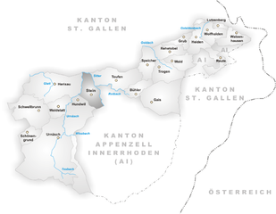
Appenzell Ausserrhoden (Appenzell Ausserrhoden)


- canton of Switzerland
 Hiking in Appenzell Ausserrhoden
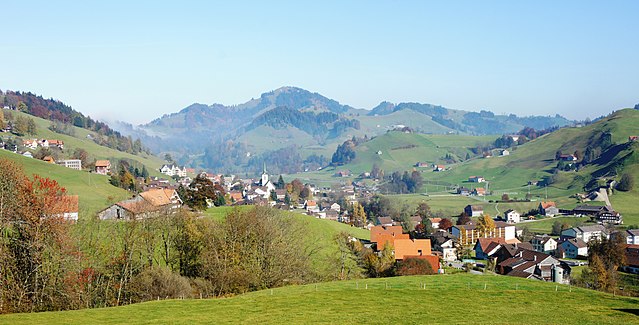
Hiking in the Canton of Appenzell Ausserrhoden offers stunning landscapes, picturesque villages, and well-marked trails that cater to various skill levels. This region in Switzerland is known for its rolling hills, picturesque mountains, and scenic views of the surrounding areas.
Key Highlights:
-
Scenic Trails:
- There are numerous hiking routes ranging from easy walks suitable for families to more challenging paths for experienced hikers. The trails are typically well-maintained and clearly marked.
- Popular hikes include the trails around the Alpstein massif, which offers breathtaking views and the chance to explore local flora and fauna.
-
Cultural Experience:
- Hiking in Appenzell Ausserrhoden often includes charming encounters with local culture. The region is known for its traditional Swiss architecture and vibrant local customs, which can be seen in the villages along the trails.
- Don't miss local cheese and other dairy products, which are a highlight in this agrarian region.
-
Elevation and Scenic Views:
- Higher trails provide access to panoramic views of the Alps on clear days. The Säntis peak is a focal point for many hikers, providing a striking backdrop.
- The region's varied elevation means that hikers can find routes suitable for their preferred intensity level.
-
Accessibility:
- Many trails are easily accessible from the main towns, such as Appenzell or Herisau. There are public transportation options available to help you reach trailheads.
- Consider using local transportation, like postbuses, which are designed to take hikers to remote and scenic trailheads.
-
Safety and Preparedness:
- Always check the weather before heading out, as conditions can change rapidly in the mountains.
- Familiarize yourself with trail maps and recommended gear, such as sturdy hiking boots, water, snacks, and appropriate clothing.
-
Family Friendly:
- There are many family-friendly trails that include playful elements, such as the "Hiking through Fairy Tale Landscapes" trail, which features storytelling stations along the route.
-
Seasonal Considerations:
- Spring and summer are popular times for hiking, but autumn can also be beautiful with stunning fall colors. Winter hiking is possible on certain trails, but check for conditions and safety advice.
Suggested Hikes:
- Appenzeller Höhenweg (Appenzeller High Trail): A stunning multi-stage trail that provides breathtaking scenery and a true taste of the region's landscapes.
- Säntis Trail: For the more adventurous, this trail leads to the summit of Säntis, the highest peak in the region, offering some of the best panoramic views.
- Tüfels Chilen: A shorter hike suitable for families, which is known for its beautiful scenery and well-preserved cultural landmarks.
Conclusion:
Hiking in Appenzell Ausserrhoden offers a unique blend of natural beauty and cultural richness. Whether you're a seasoned hiker or a beginner, the trails around this picturesque canton provide an excellent opportunity to enjoy the great outdoors and experience Swiss culture. Always remember to respect nature and local customs while enjoying your hiking adventure!
- Country:

- Capital: Trogen
- Licence Plate Code: AR
- Coordinates: 47° 3' 0" N, 9° 1' 0" E


- GPS tracks (wikiloc): [Link]
- AboveSeaLevel: 771 м m
- Area: 242.84 sq km
- Web site: http://www.ar.ch/
- Wikipedia en: wiki(en)
- Wikipedia: wiki(de)
- Wikidata storage: Wikidata: Q12079
- Wikipedia Commons Gallery: [Link]
- Wikipedia Commons Category: [Link]
- Freebase ID: [/m/01v5tf]
- GeoNames ID: Alt: [2661739]
- BnF ID: [131770733]
- VIAF ID: Alt: [148933771]
- OSM relation ID: [1686649]
- GND ID: Alt: [4002486-6]
- archINFORM location ID: [2687]
- Library of Congress authority ID: Alt: [n82039929]
- Quora topic ID: [Canton-of-Appenzell-Ausserrhoden]
- TGN ID: [7003743]
- SUDOC authorities ID: [028991753]
- Gran Enciclopèdia Catalana ID: [0004550]
- HDS ID: [7476]
- ISNI: Alt: [0000 0001 2181 5338]
- NUTS code: [CH053]
- STW Thesaurus for Economics ID: [16957-4]
- ISO 3166-2 code: CH-AR
- FIPS 10-4 (countries and regions): SZ02
Includes regions:


Herisau
- municipality in Switzerland
Hiking in Herisau
Herisau is a charming village located in the Appenzell region of Switzerland, surrounded by picturesque landscapes and rolling hills. It's an excellent destination for hiking enthusiasts, offering a variety of trails suitable for different skill levels. Here are some highlights of hiking in Herisau:...
- Country:
- Postal Code: 9100
- Local Dialing Code: 071
- Licence Plate Code: AR
- Coordinates: 47° 23' 6" N, 9° 16' 43" E
- GPS tracks (wikiloc): [Link]
- AboveSeaLevel: 738 м m
- Area: 25.2 sq km
- Population: 15780
- Web site: [Link]


Schönengrund
- municipality in Switzerland
Hiking in Schönengrund
Schönengrund is a picturesque village located in the Appenzell Innerrhoden region of Switzerland, surrounded by stunning landscapes and natural beauty. Hiking in and around Schönengrund offers a variety of trails that cater to different skill levels, making it a fantastic destination for both novice and experienced hikers....
- Country:
- Postal Code: 9105
- Local Dialing Code: 071
- Licence Plate Code: AR
- Coordinates: 47° 19' 15" N, 9° 13' 54" E
- GPS tracks (wikiloc): [Link]
- AboveSeaLevel: 970 м m
- Area: 5.21 sq km
- Population: 518
- Web site: [Link]


Walzenhausen
- municipality in Switzerland
Hiking in Walzenhausen
Walzenhausen, located in Switzerland, is an excellent destination for hiking enthusiasts. Situated in the canton of Appenzell, it offers stunning views of the surrounding landscapes, including the Rhine Valley and the Swiss Alps....
- Country:
- Postal Code: 9428
- Local Dialing Code: 071
- Licence Plate Code: AR
- Coordinates: 47° 26' 37" N, 9° 35' 51" E
- GPS tracks (wikiloc): [Link]
- AboveSeaLevel: 824 м m
- Area: 6.98 sq km
- Population: 1994
- Web site: [Link]


Schwellbrunn
- municipality in Appenzell Ausserrhoden, Switzerland
Hiking in Schwellbrunn
Schwellbrunn is a picturesque village located in the Appenzell region of Switzerland, nestled amidst stunning landscapes that are perfect for hiking enthusiasts. The area is known for its rolling hills, lush forests, and striking mountain views, making it an ideal destination for both casual walkers and experienced hikers....
- Country:
- Postal Code: 9103
- Local Dialing Code: 071
- Licence Plate Code: AR
- Coordinates: 47° 21' 8" N, 9° 14' 56" E
- GPS tracks (wikiloc): [Link]
- AboveSeaLevel: 914 м m
- Area: 17.31 sq km
- Population: 1579
- Web site: [Link]


Wolfhalden
- municipality in Switzerland
Hiking in Wolfhalden
Wolfhalden is a picturesque municipality in the Appenzell Innerrhoden region of Switzerland, surrounded by beautiful landscapes and offering a range of hiking opportunities. Here’s what you need to know about hiking in this area:...
- Country:
- Postal Code: 9427
- Local Dialing Code: 071
- Licence Plate Code: AR
- Coordinates: 47° 26' 59" N, 9° 33' 38" E
- GPS tracks (wikiloc): [Link]
- AboveSeaLevel: 673 м m
- Area: 6.95 sq km
- Population: 1836
- Web site: [Link]


Reute
- municipality in the canton of Aargau, Switzerland
Hiking in Reute
Reute is a beautiful area located in Germany, particularly noted for its picturesque landscapes and hiking opportunities. Here are some key points about hiking in Reute:...
- Country:
- Postal Code: 9411
- Local Dialing Code: 071
- Licence Plate Code: AR
- Coordinates: 47° 25' 10" N, 9° 34' 30" E
- GPS tracks (wikiloc): [Link]
- AboveSeaLevel: 703 м m
- Area: 4.99 sq km
- Population: 690
- Web site: [Link]


Speicher
- municipality in Switzerland
Hiking in Speicher
Speicher, located in the Appenzell Region of Switzerland, is an ideal destination for hiking enthusiasts. The area offers a picturesque blend of meadows, forests, and stunning mountain views. Here are some key highlights of hiking in Speicher:...
- Country:
- Postal Code: 9042
- Local Dialing Code: 071
- Licence Plate Code: AR
- Coordinates: 47° 24' 38" N, 9° 26' 36" E
- GPS tracks (wikiloc): [Link]
- AboveSeaLevel: 936 м m
- Area: 8.17 sq km
- Population: 4293
- Web site: [Link]

Urnäsch
- municipality in Switzerland
Hiking in Urnäsch
Urnäsch is a picturesque village located in the Appenzellerland region of Switzerland, providing a stunning backdrop for hiking enthusiasts. The area is characterized by rolling hills, lush meadows, and stunning views of the surrounding Swiss Alps. Here are some highlights and tips for hiking in Urnäsch:...
- Country:
- Postal Code: 9107
- Local Dialing Code: 071
- Licence Plate Code: AR
- Coordinates: 47° 17' 48" N, 9° 16' 3" E
- GPS tracks (wikiloc): [Link]
- AboveSeaLevel: 866 м m
- Area: 48.3 sq km
- Population: 2315
- Web site: [Link]


Gais
- municipality in Switzerland
Hiking in Gais
Gais, a charming village in the Appenzell Innerrhoden region of Switzerland, offers stunning hiking opportunities suitable for various skill levels. The surrounding landscapes are characterized by rolling hills, lush meadows, and spectacular mountain views, making it a paradise for outdoor enthusiasts....
- Country:
- Postal Code: 9056
- Local Dialing Code: 071
- Licence Plate Code: AR
- Coordinates: 47° 21' 38" N, 9° 27' 4" E
- GPS tracks (wikiloc): [Link]
- AboveSeaLevel: 983 м m
- Area: 21.23 sq km
- Population: 3096
- Web site: [Link]


Wald
- municipality in the canton Appenzell Ausserrhoden, Switzerland
Hiking in Wald
Wald, located in the Appenzell Ausserrhoden region of Switzerland, offers beautiful hiking opportunities amidst stunning natural landscapes. The area is characterized by rolling hills, vibrant meadows, and picturesque views of the nearby mountains, making it a fantastic destination for both casual walkers and seasoned hikers....
- Country:
- Postal Code: 9044
- Local Dialing Code: 071
- Licence Plate Code: AR
- Coordinates: 47° 24' 56" N, 9° 29' 25" E
- GPS tracks (wikiloc): [Link]
- AboveSeaLevel: 962 м m
- Area: 6.82 sq km
- Population: 857
- Web site: [Link]


Lutzenberg
- municipality in Switzerland
Hiking in Lutzenberg
Lutzenberg is a charming community located in the Appenzell District of Switzerland, known for its picturesque landscapes and proximity to the beautiful Appenzell region. Hiking in Lutzenberg offers stunning vistas of rolling hills, lush forests, and scenic views of the Swiss Alps....
- Country:
- Postal Code: 9426
- Local Dialing Code: 071
- Licence Plate Code: AR
- Coordinates: 47° 27' 29" N, 9° 35' 1" E
- GPS tracks (wikiloc): [Link]
- AboveSeaLevel: 523 м m
- Area: 2.26 sq km
- Population: 1253
- Web site: [Link]


Rehetobel
- municipality in Switzerland
Hiking in Rehetobel
Rehetobel is a scenic area located in the canton of Appenzell in Switzerland, known for its picturesque landscapes and hiking opportunities. Here are some highlights and tips for hiking in Rehetobel:...
- Country:
- Postal Code: 9038
- Local Dialing Code: 071
- Licence Plate Code: AR
- Coordinates: 47° 25' 40" N, 9° 28' 54" E
- GPS tracks (wikiloc): [Link]
- AboveSeaLevel: 940 м m
- Area: 6.72 sq km
- Population: 1750
- Web site: [Link]

Stein
- municipality in Switzerland
Hiking in Stein
Hiking in Stein, located in the Appenzell region of Switzerland, offers a fantastic experience surrounded by stunning landscapes, rolling hills, and mountainous terrain. This area is known for its picturesque scenery, vibrant green meadows, and traditional Swiss chalets, making it a perfect destination for outdoor enthusiasts....
- Country:
- Postal Code: 9063
- Local Dialing Code: 071
- Licence Plate Code: AR
- Coordinates: 47° 22' 36" N, 9° 20' 30" E
- GPS tracks (wikiloc): [Link]
- AboveSeaLevel: 800 м m
- Area: 9.37 sq km
- Population: 1423
- Web site: [Link]


Bühler
- municipality in Switzerland
Hiking in Bühler
Bühler is a beautiful area known for its stunning landscapes and hiking opportunities. Whether you're looking for leisurely walks or more challenging trails, Bühler offers a variety of options for outdoor enthusiasts....
- Country:
- Postal Code: 9055
- Local Dialing Code: 071
- Licence Plate Code: AR
- Coordinates: 47° 22' 22" N, 9° 25' 16" E
- GPS tracks (wikiloc): [Link]
- AboveSeaLevel: 824 м m
- Area: 5.61 sq km
- Population: 1766
- Web site: [Link]


Grub
- municipality in Switzerland
Hiking in Grub
Grub, located in the Appenzell Ausserrhoden region of Switzerland, is known for its stunning scenic beauty and a variety of hiking trails that cater to different skill levels. Here’s a brief overview of what you can expect when hiking in this beautiful area:...
- Country:
- Postal Code: 9035
- Local Dialing Code: 071
- Licence Plate Code: AR
- Coordinates: 47° 26' 53" N, 9° 30' 34" E
- GPS tracks (wikiloc): [Link]
- AboveSeaLevel: 986 м m
- Area: 4.22 sq km
- Population: 1045
- Web site: [Link]


Teufen
- municipality in Switzerland
Hiking in Teufen
Teufen, located in Appenzell Ausserrhoden, Switzerland, offers a stunning setting for hiking enthusiasts. The region is characterized by beautiful meadows, rolling hills, and breathtaking views of the Appenzell Alps. Here are some highlights of hiking in this area:...
- Country:
- Postal Code: 9053
- Local Dialing Code: 071
- Licence Plate Code: AR
- Coordinates: 47° 23' 37" N, 9° 23' 19" E
- GPS tracks (wikiloc): [Link]
- AboveSeaLevel: 875 м m
- Area: 15.3 sq km
- Population: 6267
- Web site: [Link]

Trogen
- municipality in Switzerland
Hiking in Trogen
Trogen is a charming village located in the Appenzell region of Switzerland, surrounded by beautiful landscapes, rolling hills, and stunning views of the Alps. The area is known for its varied hiking trails that cater to all levels of experience, making it an excellent destination for both novice and experienced hikers....
- Country:
- Postal Code: 9043
- Local Dialing Code: 071
- Licence Plate Code: AR
- Coordinates: 47° 24' 27" N, 9° 27' 53" E
- GPS tracks (wikiloc): [Link]
- AboveSeaLevel: 903 м m
- Area: 10.02 sq km
- Population: 1721
- Web site: [Link]


Heiden
- municipality in Switzerland
Hiking in Heiden
Heiden is a picturesque village located in the Appenzell region of Switzerland, known for its stunning views of Lake Constance and its surrounding mountains. Hiking in and around Heiden offers a range of scenic trails suitable for different skill levels, making it a delightful destination for outdoor enthusiasts. Here are some highlights:...
- Country:
- Postal Code: 9410
- Local Dialing Code: 071
- Licence Plate Code: AR
- Coordinates: 47° 26' 28" N, 9° 31' 52" E
- GPS tracks (wikiloc): [Link]
- AboveSeaLevel: 802 м m
- Area: 7.5 sq km
- Population: 4192
- Web site: [Link]


Hundwil
- municipality in Switzerland
Hiking in Hundwil
Hundwil is a charming village located in the Appenzell region of Switzerland, surrounded by picturesque landscapes and rolling hills, making it an excellent destination for hiking enthusiasts. The area offers a variety of well-marked trails suitable for different skill levels, from leisurely walks to more challenging hikes....
- Country:
- Postal Code: 9064
- Local Dialing Code: 071
- Licence Plate Code: AR
- Coordinates: 47° 21' 55" N, 9° 19' 10" E
- GPS tracks (wikiloc): [Link]
- AboveSeaLevel: 897 м m
- Area: 23.96 sq km
- Population: 957
- Web site: [Link]


Waldstatt
- municipality in Switzerland
Hiking in Waldstatt
Waldstatt, located in the picturesque region of Appenzell Innerrhoden in Switzerland, offers some delightful hiking opportunities with its stunning landscapes, rolling hills, and serene trails. Here are some highlights and tips for hiking in Waldstatt:...
- Country:
- Postal Code: 9104
- Local Dialing Code: 071
- Licence Plate Code: AR
- Coordinates: 47° 21' 25" N, 9° 17' 4" E
- GPS tracks (wikiloc): [Link]
- AboveSeaLevel: 821 м m
- Area: 6.74 sq km
- Population: 1846
- Web site: [Link]
Shares border with regions:


Appenzell Innerrhoden
- canton of Switzerland
Hiking in Appenzell Innerrhoden
Hiking in the Canton of Appenzell Innerrhoden, located in eastern Switzerland, offers a unique opportunity to explore stunning landscapes, rich culture, and well-maintained trails. Here are some highlights and tips for hiking in this picturesque region:...
- Country:
- Licence Plate Code: AI
- Coordinates: 47° 18' 0" N, 9° 24' 0" E
- GPS tracks (wikiloc): [Link]
- AboveSeaLevel: 780 м m
- Area: 172.48 sq km
- Web site: [Link]


Canton of St. Gallen
- canton of Switzerland
Hiking in Canton of St. Gallen
The Canton of St. Gallen, located in eastern Switzerland, is a fantastic destination for hiking enthusiasts, boasting a diverse range of trails that cater to various skill levels and interests. Here's an overview of what you can expect:...
- Country:
- Capital: St. Gallen
- Licence Plate Code: SG
- Coordinates: 47° 20' 0" N, 9° 10' 0" E
- GPS tracks (wikiloc): [Link]
- AboveSeaLevel: 668 м m
- Area: 2030.75 sq km
- Population: 75538
- Web site: [Link]