Trogen (Trogen)

- municipality in Switzerland
 Hiking in Trogen
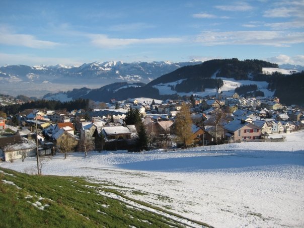
Trogen is a charming village located in the Appenzell region of Switzerland, surrounded by beautiful landscapes, rolling hills, and stunning views of the Alps. The area is known for its varied hiking trails that cater to all levels of experience, making it an excellent destination for both novice and experienced hikers.
Hiking Overview:
-
Trail Varieties:
- There are numerous hiking routes starting from Trogen, ranging from easy walks to more challenging treks. You can find paths that lead through picturesque meadows, dense forests, and up to panoramic viewpoints.
- Some popular routes include the trail to the nearby mountain of "Säntis," which offers breathtaking views, as well as more local paths that explore the quaint surroundings of Trogen itself.
-
Scenic Views:
- Hikers can enjoy stunning views of the Appenzell region, with its characteristic rolling hills, small lakes, and the distant peaks of the Alps, making for memorable photo opportunities.
-
Cultural Experience:
- Trogen is rich in Swiss culture, and hiking gives you a chance to experience traditional Alpine villages, local farms, and perhaps encounter friendly locals along the way.
- Be sure to check out the local architecture, including the charming wooden houses typical of the region.
-
Wildlife and Nature:
- When hiking, keep an eye out for diverse flora and fauna; the region is home to various bird species, wildflowers, and other wildlife.
- The best time to experience nature is during the spring and summer months when wildflowers are in bloom and the weather is generally mild.
-
Gear and Preparation:
- As always, prepare adequately for your hikes. Wear appropriate footwear, carry sufficient water, and pack snacks. A hiking map or a downloaded trail app can be very handy.
- Always check the weather forecast before heading out, as conditions in the mountains can change quickly.
-
Accessibility:
- Trogen is well connected by public transportation to other parts of the Appenzell area, making it easy to start your hike from a variety of nearby points.
Hiking in Trogen allows you to enjoy both the natural beauty and cultural richness of Switzerland, making it a delightful destination for outdoor enthusiasts.
- Country:

- Postal Code: 9043
- Local Dialing Code: 071
- Licence Plate Code: AR
- Coordinates: 47° 24' 27" N, 9° 27' 53" E


- GPS tracks (wikiloc): [Link]
- AboveSeaLevel: 903 м m
- Area: 10.02 sq km
- Population: 1721
- Web site: http://www.trogen.ch
- Wikipedia en: wiki(en)
- Wikipedia: wiki(de)
- Wikidata storage: Wikidata: Q68189
- Wikipedia Commons Category: [Link]
- Freebase ID: [/m/01v698]
- GeoNames ID: Alt: [7287337]
- OSM relation ID: [1683949]
- GND ID: Alt: [4106969-9]
- archINFORM location ID: [1485]
- MusicBrainz area ID: [7fed196e-bd1a-49a0-8801-b06130c833bb]
- HDS ID: [1304]
- Swiss municipality code: [3025]
Shares border with regions:


Speicher
- municipality in Switzerland
Hiking in Speicher
Speicher, located in the Appenzell Region of Switzerland, is an ideal destination for hiking enthusiasts. The area offers a picturesque blend of meadows, forests, and stunning mountain views. Here are some key highlights of hiking in Speicher:...
- Country:
- Postal Code: 9042
- Local Dialing Code: 071
- Licence Plate Code: AR
- Coordinates: 47° 24' 38" N, 9° 26' 36" E
- GPS tracks (wikiloc): [Link]
- AboveSeaLevel: 936 м m
- Area: 8.17 sq km
- Population: 4293
- Web site: [Link]


Gais
- municipality in Switzerland
Hiking in Gais
Gais, a charming village in the Appenzell Innerrhoden region of Switzerland, offers stunning hiking opportunities suitable for various skill levels. The surrounding landscapes are characterized by rolling hills, lush meadows, and spectacular mountain views, making it a paradise for outdoor enthusiasts....
- Country:
- Postal Code: 9056
- Local Dialing Code: 071
- Licence Plate Code: AR
- Coordinates: 47° 21' 38" N, 9° 27' 4" E
- GPS tracks (wikiloc): [Link]
- AboveSeaLevel: 983 м m
- Area: 21.23 sq km
- Population: 3096
- Web site: [Link]


Wald
- municipality in the canton Appenzell Ausserrhoden, Switzerland
Hiking in Wald
Wald, located in the Appenzell Ausserrhoden region of Switzerland, offers beautiful hiking opportunities amidst stunning natural landscapes. The area is characterized by rolling hills, vibrant meadows, and picturesque views of the nearby mountains, making it a fantastic destination for both casual walkers and seasoned hikers....
- Country:
- Postal Code: 9044
- Local Dialing Code: 071
- Licence Plate Code: AR
- Coordinates: 47° 24' 56" N, 9° 29' 25" E
- GPS tracks (wikiloc): [Link]
- AboveSeaLevel: 962 м m
- Area: 6.82 sq km
- Population: 857
- Web site: [Link]


Rehetobel
- municipality in Switzerland
Hiking in Rehetobel
Rehetobel is a scenic area located in the canton of Appenzell in Switzerland, known for its picturesque landscapes and hiking opportunities. Here are some highlights and tips for hiking in Rehetobel:...
- Country:
- Postal Code: 9038
- Local Dialing Code: 071
- Licence Plate Code: AR
- Coordinates: 47° 25' 40" N, 9° 28' 54" E
- GPS tracks (wikiloc): [Link]
- AboveSeaLevel: 940 м m
- Area: 6.72 sq km
- Population: 1750
- Web site: [Link]


Bühler
- municipality in Switzerland
Hiking in Bühler
Bühler is a beautiful area known for its stunning landscapes and hiking opportunities. Whether you're looking for leisurely walks or more challenging trails, Bühler offers a variety of options for outdoor enthusiasts....
- Country:
- Postal Code: 9055
- Local Dialing Code: 071
- Licence Plate Code: AR
- Coordinates: 47° 22' 22" N, 9° 25' 16" E
- GPS tracks (wikiloc): [Link]
- AboveSeaLevel: 824 м m
- Area: 5.61 sq km
- Population: 1766
- Web site: [Link]


Altstätten
- municipality in Switzerland
Hiking in Altstätten
Altstätten, located in the eastern part of Switzerland, is a charming town nestled near the Appenzell region, offering a variety of hiking opportunities that cater to all levels of hikers. The surrounding landscape is characterized by rolling hills, lush forests, and stunning mountain views, making it a fantastic destination for outdoor enthusiasts....
- Country:
- Postal Code: 9450
- Local Dialing Code: 071
- Licence Plate Code: SG
- Coordinates: 47° 22' 41" N, 9° 32' 56" E
- GPS tracks (wikiloc): [Link]
- AboveSeaLevel: 465 м m
- Area: 39.11 sq km
- Population: 11549
- Web site: [Link]
Oberegg
- municipality in Switzerland
Hiking in Oberegg
Hiking in the Oberegg District, located in the canton of Appenzell Innerrhoden in Switzerland, offers a beautiful blend of scenic landscapes, cultural experiences, and varied terrains. This area is characterized by rolling hills, lush fields, and magnificent views of the surrounding mountains, making it a perfect destination for both novice and experienced hikers....
- Country:
- Postal Code: 9413
- Local Dialing Code: 071
- Licence Plate Code: AI
- Coordinates: 47° 25' 1" N, 9° 33' 27" E
- GPS tracks (wikiloc): [Link]
- AboveSeaLevel: 885 м m
- Area: 14.7 sq km
- Population: 1907
- Web site: [Link]