Reilhac (Reilhac)

- commune in Cantal, France
- Country:

- Postal Code: 15250
- Coordinates: 44° 58' 25" N, 2° 25' 16" E


- GPS tracks (wikiloc): [Link]
- Area: 8.89 sq km
- Population: 1093
- Wikipedia en: wiki(en)
- Wikipedia: wiki(fr)
- Wikidata storage: Wikidata: Q270472
- Wikipedia Commons Category: [Link]
- Freebase ID: [/m/03mb9l2]
- GeoNames ID: Alt: [6613604]
- SIREN number: [211502919]
- BnF ID: [15248330q]
- INSEE municipality code: 15160
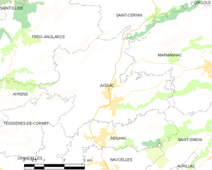
Shares border with regions:


Naucelles
- commune in Cantal, France
- Country:
- Postal Code: 15000
- Coordinates: 44° 57' 32" N, 2° 25' 8" E
- GPS tracks (wikiloc): [Link]
- Area: 11.69 sq km
- Population: 1968
- Web site: [Link]


Saint-Simon
- commune in Cantal, France
- Country:
- Postal Code: 15130
- Coordinates: 44° 57' 47" N, 2° 29' 24" E
- GPS tracks (wikiloc): [Link]
- Area: 27.27 sq km
- Population: 1166
- Web site: [Link]

Jussac
- commune in Cantal, France
- Country:
- Postal Code: 15250
- Coordinates: 44° 59' 15" N, 2° 25' 23" E
- GPS tracks (wikiloc): [Link]
- Area: 18.43 sq km
- Population: 2015
- Web site: [Link]
Crandelles
- commune in Cantal, France
- Country:
- Postal Code: 15250
- Coordinates: 44° 57' 31" N, 2° 20' 58" E
- GPS tracks (wikiloc): [Link]
- AboveSeaLevel: 620 м m
- Area: 12.46 sq km
- Population: 818