Jussac (Jussac)

- commune in Cantal, France
- Country:

- Postal Code: 15250
- Coordinates: 44° 59' 15" N, 2° 25' 23" E


- GPS tracks (wikiloc): [Link]
- Area: 18.43 sq km
- Population: 2015
- Web site: http://www.jussac.fr
- Wikipedia en: wiki(en)
- Wikipedia: wiki(fr)
- Wikidata storage: Wikidata: Q547456
- Wikipedia Commons Category: [Link]
- Freebase ID: [/m/03mb7hr]
- GeoNames ID: Alt: [6613603]
- SIREN number: [211500830]
- BnF ID: [152482533]
- INSEE municipality code: 15083
Shares border with regions:
Freix-Anglards
- commune in Cantal, France
- Country:
- Postal Code: 15310
- Coordinates: 45° 1' 17" N, 2° 23' 10" E
- GPS tracks (wikiloc): [Link]
- AboveSeaLevel: 800 м m
- Area: 17.69 sq km
- Population: 210


Saint-Simon
- commune in Cantal, France
- Country:
- Postal Code: 15130
- Coordinates: 44° 57' 47" N, 2° 29' 24" E
- GPS tracks (wikiloc): [Link]
- Area: 27.27 sq km
- Population: 1166
- Web site: [Link]


Reilhac
- commune in Cantal, France
- Country:
- Postal Code: 15250
- Coordinates: 44° 58' 25" N, 2° 25' 16" E
- GPS tracks (wikiloc): [Link]
- Area: 8.89 sq km
- Population: 1093

Ayrens
- commune in Cantal, France
- Country:
- Postal Code: 15250
- Coordinates: 44° 59' 5" N, 2° 19' 37" E
- GPS tracks (wikiloc): [Link]
- Area: 25.5 sq km
- Population: 654


Marmanhac
- commune in Cantal, France
- Country:
- Postal Code: 15250
- Coordinates: 45° 0' 13" N, 2° 28' 56" E
- GPS tracks (wikiloc): [Link]
- Area: 24.24 sq km
- Population: 712

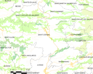
Saint-Cernin
- commune in Cantal, France
- Country:
- Postal Code: 15310
- Coordinates: 45° 3' 31" N, 2° 25' 15" E
- GPS tracks (wikiloc): [Link]
- Area: 46.75 sq km
- Population: 1087
- Web site: [Link]
Teissières-de-Cornet
- commune in Cantal, France
- Country:
- Postal Code: 15250
- Coordinates: 44° 58' 13" N, 2° 21' 19" E
- GPS tracks (wikiloc): [Link]
- Area: 9.32 sq km
- Population: 285
Crandelles
- commune in Cantal, France
- Country:
- Postal Code: 15250
- Coordinates: 44° 57' 31" N, 2° 20' 58" E
- GPS tracks (wikiloc): [Link]
- AboveSeaLevel: 620 м m
- Area: 12.46 sq km
- Population: 818