Remoncourt (Remoncourt)

- commune in Vosges, France
- Country:

- Postal Code: 88800
- Coordinates: 48° 13' 46" N, 6° 3' 6" E


- GPS tracks (wikiloc): [Link]
- Area: 14.52 sq km
- Population: 627
- Wikipedia en: wiki(en)
- Wikipedia: wiki(fr)
- Wikidata storage: Wikidata: Q1455570
- Wikipedia Commons Category: [Link]
- Freebase ID: [/m/03qhfls]
- Freebase ID: [/m/03qhfls]
- GeoNames ID: Alt: [6614903]
- GeoNames ID: Alt: [6614903]
- SIREN number: [218803856]
- SIREN number: [218803856]
- BnF ID: [152793072]
- BnF ID: [152793072]
- INSEE municipality code: 88385
- INSEE municipality code: 88385
Shares border with regions:

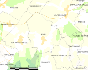
Esley
- commune in Vosges, France
- Country:
- Postal Code: 88260
- Coordinates: 48° 10' 10" N, 6° 3' 28" E
- GPS tracks (wikiloc): [Link]
- Area: 11 sq km
- Population: 182


Estrennes
- commune in Vosges, France
- Country:
- Postal Code: 88500
- Coordinates: 48° 15' 30" N, 6° 3' 0" E
- GPS tracks (wikiloc): [Link]
- Area: 5.99 sq km
- Population: 92


Domèvre-sous-Montfort
- commune in Vosges, France
- Country:
- Postal Code: 88500
- Coordinates: 48° 15' 1" N, 6° 4' 3" E
- GPS tracks (wikiloc): [Link]
- Area: 3.28 sq km
- Population: 58


La Neuveville-sous-Montfort
- commune in Vosges, France
- Country:
- Postal Code: 88800
- Coordinates: 48° 13' 28" N, 6° 1' 6" E
- GPS tracks (wikiloc): [Link]
- Area: 10.21 sq km
- Population: 176

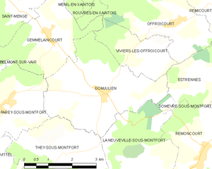
Domjulien
- commune in Vosges, France
- Country:
- Postal Code: 88800
- Coordinates: 48° 15' 9" N, 5° 59' 49" E
- GPS tracks (wikiloc): [Link]
- Area: 11.94 sq km
- Population: 183

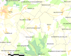
Monthureux-le-Sec
- commune in Vosges, France
- Country:
- Postal Code: 88800
- Coordinates: 48° 10' 17" N, 6° 1' 32" E
- GPS tracks (wikiloc): [Link]
- Area: 11.36 sq km
- Population: 162


Valfroicourt
- commune in Vosges, France
- Country:
- Postal Code: 88270
- Coordinates: 48° 11' 52" N, 6° 5' 41" E
- GPS tracks (wikiloc): [Link]
- Area: 13.8 sq km
- Population: 246

Haréville
- commune in Vosges, France
- Country:
- Postal Code: 88800
- Coordinates: 48° 12' 21" N, 6° 0' 1" E
- GPS tracks (wikiloc): [Link]
- Area: 6.56 sq km
- Population: 484


Rozerotte
- commune in Vosges, France
- Country:
- Postal Code: 88500
- Coordinates: 48° 14' 30" N, 6° 4' 53" E
- GPS tracks (wikiloc): [Link]
- Area: 6.46 sq km
- Population: 194