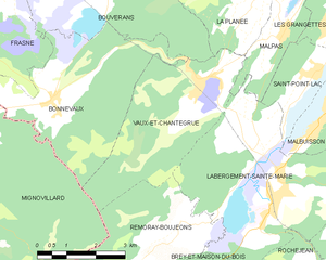
Remoray-Boujeons (Remoray-Boujeons)

- commune in Doubs, France
 Hiking in Remoray-Boujeons
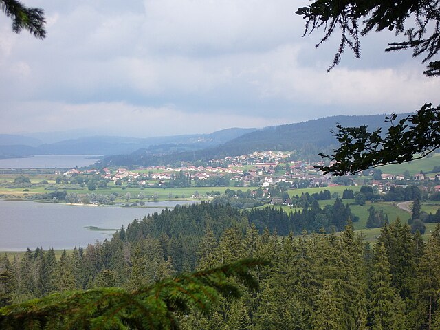
Remoray-Boujeons, located in the Jura Mountains of France, offers a variety of hiking opportunities that are perfect for outdoor enthusiasts of all levels. This region is known for its beautiful landscapes, rich biodiversity, and serene lakes. Here are some key points to consider when planning a hike in the area:
Highlights of Hiking in Remoray-Boujeons:
-
Scenic Trails: The area boasts a network of well-marked hiking trails that wind through forests, pastures, and along the shores of the picturesque Remoray Lake. The trails vary in difficulty, making it suitable for families, casual walkers, and more experienced hikers.
-
Stunning Views: The Jura Mountains provide breathtaking panoramic views of the surrounding landscape. Many trails offer scenic overlooks where you can take in the beauty of the rolling hills and the tranquility of the natural surroundings.
-
LGBT-Friendly Areas: The region is known for its welcoming atmosphere and has designated areas that are particularly inclusive for LGBTQ+ travelers.
-
Flora and Fauna: As you hike, you'll encounter diverse plant and animal life. Keep an eye out for local wildlife, including deer, foxes, and an array of bird species. The region is also home to unique flora, including rare plant species.
-
Cultural Heritage: Along the hiking routes, you may discover small villages and historical sites that reflect the cultural heritage of the Jura region, providing a deeper understanding of the area's history and traditions.
Hiking Tips:
-
Preparation: Make sure to check the weather conditions before you set out, as they can change quickly in the mountains. Wear appropriate footwear and clothing for varying terrain and weather.
-
Maps and Guides: It's a good idea to have a detailed map of the hiking trails or consider using a hiking app. Local tourist offices often provide resources and can help you choose the best trails based on your experience level and interests.
-
Stay Hydrated and Snack: Bring enough water and snacks to keep your energy levels up throughout your hike.
-
Respect Nature: Follow Leave No Trace principles to preserve the natural beauty of the area. Stay on marked trails, and be mindful of wildlife.
-
Safety: If you're hiking alone, inform someone of your plans and expected return time. Mobile service can be spotty, so having a whistle or a basic first-aid kit is advisable.
Hiking in Remoray-Boujeons can be a fulfilling experience with the perfect blend of nature, adventure, and culture. Enjoy your hike!
- Country:

- Postal Code: 25160
- Coordinates: 46° 46' 3" N, 6° 14' 20" E


- GPS tracks (wikiloc): [Link]
- Area: 15.15 sq km
- Population: 412
- Wikipedia en: wiki(en)
- Wikipedia: wiki(fr)
- Wikidata storage: Wikidata: Q909926
- Wikipedia Commons Category: [Link]
- Freebase ID: [/m/03mhc92]
- Freebase ID: [/m/03mhc92]
- GeoNames ID: Alt: [6616231]
- GeoNames ID: Alt: [6616231]
- SIREN number: [212504864]
- SIREN number: [212504864]
- BnF ID: [15252712n]
- BnF ID: [15252712n]
- INSEE municipality code: 25486
- INSEE municipality code: 25486
Shares border with regions:


Mignovillard
- former commune in Jura, France
Hiking in Mignovillard
Mignovillard, located in the Jura department of France, is a charming destination for hiking enthusiasts. Nestled in the foothills of the Jura Mountains, it offers a variety of trails that cater to different skill levels, from leisurely walks to more challenging hikes....
- Country:
- Postal Code: 39250
- Coordinates: 46° 47' 29" N, 6° 7' 33" E
- GPS tracks (wikiloc): [Link]
- Area: 49.81 sq km
- Population: 743
- Web site: [Link]


Rondefontaine
- commune in Doubs, France
Hiking in Rondefontaine
Rondefontaine, located in the French region of Auvergne-Rhône-Alpes, offers a beautiful setting for hiking enthusiasts. This area is known for its stunning landscapes, diverse flora and fauna, and numerous trails that cater to different skill levels. Here are some key points to consider when hiking in Rondefontaine:...
- Country:
- Postal Code: 25240
- Coordinates: 46° 44' 0" N, 6° 10' 57" E
- GPS tracks (wikiloc): [Link]
- Area: 2.72 sq km
- Population: 30

Vaux-et-Chantegrue
- commune in Doubs, France
Hiking in Vaux-et-Chantegrue
Vaux-et-Chantegrue is a charming village in the Jura region of France, known for its picturesque landscapes, rolling hills, and tranquil natural surroundings. The area offers several hiking opportunities that allow you to explore its beauty....
- Country:
- Postal Code: 25160
- Coordinates: 46° 48' 39" N, 6° 14' 59" E
- GPS tracks (wikiloc): [Link]
- Area: 13.98 sq km
- Population: 544


Brey-et-Maison-du-Bois
- commune in Doubs, France
Hiking in Brey-et-Maison-du-Bois
Brey-et-Maison-du-Bois is a charming village located in the Jura region of France, known for its beautiful natural landscapes and tranquil hiking trails. The area is characterized by lush forests, rolling hills, and picturesque vistas, making it a great destination for outdoor enthusiasts....
- Country:
- Postal Code: 25240
- Coordinates: 46° 44' 39" N, 6° 15' 6" E
- GPS tracks (wikiloc): [Link]
- Area: 6.18 sq km
- Population: 104


Sarrageois
- commune in Doubs, France
Hiking in Sarrageois
Sarrageois, located in the Jura mountains of France, is known for its stunning natural beauty and diverse hiking trails. The region offers a mix of landscapes, from lush forests and rolling hills to dramatic cliffs and serene lakes, making it an ideal destination for outdoor enthusiasts....
- Country:
- Postal Code: 25240
- Coordinates: 46° 43' 31" N, 6° 12' 59" E
- GPS tracks (wikiloc): [Link]
- Area: 13.22 sq km
- Population: 191

Labergement-Sainte-Marie
- commune in Doubs, France
Hiking in Labergement-Sainte-Marie
Labergement-Sainte-Marie is a charming village located in the Doubs department of the Bourgogne-Franche-Comté region in eastern France. Nestled in the heart of the Jura Mountains, it offers beautiful landscapes, rich flora and fauna, and a variety of hiking opportunities suitable for different skill levels....
- Country:
- Postal Code: 25160
- Coordinates: 46° 46' 29" N, 6° 16' 50" E
- GPS tracks (wikiloc): [Link]
- Area: 22.12 sq km
- Population: 1160

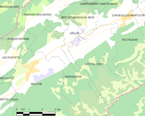
Gellin
- commune in Doubs, France
Hiking in Gellin
It seems there may be a misunderstanding, as "Gellin" does not correspond to a widely recognized hiking destination. If you meant a specific area, state, or country, please clarify the name so I can provide you with accurate information....
- Country:
- Postal Code: 25240
- Coordinates: 46° 43' 56" N, 6° 14' 17" E
- GPS tracks (wikiloc): [Link]
- Area: 4.87 sq km
- Population: 238