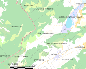
Rondefontaine (Rondefontaine)

- commune in Doubs, France
 Hiking in Rondefontaine
Rondefontaine, located in the French region of Auvergne-Rhône-Alpes, offers a beautiful setting for hiking enthusiasts. This area is known for its stunning landscapes, diverse flora and fauna, and numerous trails that cater to different skill levels. Here are some key points to consider when hiking in Rondefontaine:
-
Trails: The region boasts a variety of hiking trails ranging from easy walks suitable for families to challenging routes for experienced hikers. It is advisable to check local maps or online resources for trail conditions and lengths.
-
Scenic Views: The hikes often lead through picturesque forests, rolling hills, and along rivers, allowing for breathtaking views of the surrounding landscape. Be sure to bring a camera to capture the scenery.
-
Wildlife: Rondefontaine is home to diverse wildlife. Keep an eye out for various species of birds, deer, and other woodland creatures. Early morning hikes can offer the best chances for wildlife sightings.
-
Preparation: As with any hiking adventure, it’s essential to wear proper footwear and clothing suitable for the weather. Always bring plenty of water, snacks, and a first-aid kit. If you're hiking in more remote areas, consider informing someone of your plans.
-
Maps and Guides: Look for local hiking guides or maps that can provide information on the best trails and points of interest. Many local tourism offices can provide resources, or you can find them online.
-
Respect Nature: Make sure to follow the Leave No Trace principles. Stay on designated trails, avoid disturbing wildlife, and pack out any trash.
-
Weather: Check the weather forecast before heading out, as conditions can change rapidly in mountainous areas. Always be prepared for sudden changes in weather.
Whether you're a seasoned hiker or just looking for a leisurely stroll in nature, Rondefontaine has something to offer everyone. Enjoy your hike!
- Country:

- Postal Code: 25240
- Coordinates: 46° 44' 0" N, 6° 10' 57" E


- GPS tracks (wikiloc): [Link]
- Area: 2.72 sq km
- Population: 30
- Wikipedia en: wiki(en)
- Wikipedia: wiki(fr)
- Wikidata storage: Wikidata: Q596987
- Wikipedia Commons Category: [Link]
- Freebase ID: [/m/03mhcfk]
- Freebase ID: [/m/03mhcfk]
- GeoNames ID: Alt: [6429966]
- GeoNames ID: Alt: [6429966]
- SIREN number: [212505010]
- SIREN number: [212505010]
- BnF ID: [15252727p]
- BnF ID: [15252727p]
- INSEE municipality code: 25501
- INSEE municipality code: 25501
Shares border with regions:


Mignovillard
- former commune in Jura, France
Hiking in Mignovillard
Mignovillard, located in the Jura department of France, is a charming destination for hiking enthusiasts. Nestled in the foothills of the Jura Mountains, it offers a variety of trails that cater to different skill levels, from leisurely walks to more challenging hikes....
- Country:
- Postal Code: 39250
- Coordinates: 46° 47' 29" N, 6° 7' 33" E
- GPS tracks (wikiloc): [Link]
- Area: 49.81 sq km
- Population: 743
- Web site: [Link]


Mouthe
- commune in Doubs, France
Hiking in Mouthe
Mouthe, located in the Jura region of France, is known for its stunning natural landscapes and rich biodiversity, making it an excellent destination for hikers. Here are some key aspects to consider when hiking in Mouthe:...
- Country:
- Postal Code: 25240
- Coordinates: 46° 42' 38" N, 6° 11' 37" E
- GPS tracks (wikiloc): [Link]
- Area: 38.73 sq km
- Population: 1055
- Web site: [Link]


Les Pontets
- commune in Doubs, France
Hiking in Les Pontets
Les Pontets is a fantastic area for hiking, located in the picturesque surroundings of the French Alps, near the border of Switzerland. This region is known for its stunning landscapes, including lush valleys, majestic mountain peaks, and picturesque lakes. Here are some highlights about hiking in and around Les Pontets:...
- Country:
- Postal Code: 25240
- Coordinates: 46° 43' 9" N, 6° 10' 18" E
- GPS tracks (wikiloc): [Link]
- Area: 6.36 sq km
- Population: 142


Sarrageois
- commune in Doubs, France
Hiking in Sarrageois
Sarrageois, located in the Jura mountains of France, is known for its stunning natural beauty and diverse hiking trails. The region offers a mix of landscapes, from lush forests and rolling hills to dramatic cliffs and serene lakes, making it an ideal destination for outdoor enthusiasts....
- Country:
- Postal Code: 25240
- Coordinates: 46° 43' 31" N, 6° 12' 59" E
- GPS tracks (wikiloc): [Link]
- Area: 13.22 sq km
- Population: 191

Remoray-Boujeons
- commune in Doubs, France
Hiking in Remoray-Boujeons
Remoray-Boujeons, located in the Jura Mountains of France, offers a variety of hiking opportunities that are perfect for outdoor enthusiasts of all levels. This region is known for its beautiful landscapes, rich biodiversity, and serene lakes. Here are some key points to consider when planning a hike in the area:...
- Country:
- Postal Code: 25160
- Coordinates: 46° 46' 3" N, 6° 14' 20" E
- GPS tracks (wikiloc): [Link]
- Area: 15.15 sq km
- Population: 412