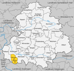
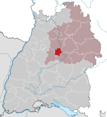
Rems-Murr (Rems-Murr-Kreis)

- district in Baden-Wurttemberg, Germany
 Hiking in Rems-Murr
Rems-Murr-Kreis, located in the Baden-Württemberg region of Germany, offers a diverse landscape for hiking enthusiasts. The area is characterized by rolling hills, vineyards, forests, and picturesque villages, making it an attractive destination for hikers of all skill levels. Here are some highlights and tips for hiking in Rems-Murr-Kreis:
Hiking Trails
-
Remstal Panoramaweg: This scenic trail runs along the Rems River and provides beautiful views of the valley, vineyards, and surrounding hills. It stretches over 140 kilometers and can be completed in sections.
-
Schurwald: The Schurwald region offers various trails that wind through dense forests and past scenic viewpoints. The terrain varies from gentle slopes to more challenging paths, catering to both casual walkers and seasoned hikers.
-
Mainhardt Forest (Mainhardtwald): This area features numerous trails through lush woodland, perfect for nature enthusiasts. It's ideal for longer hikes, and you may come across wildlife and various plant species.
-
Nature Park Swabian Jura: While a bit farther, this park is accessible and offers trails that showcase the unique geology and flora of the region. It’s known for its limestone cliffs and beautiful landscapes.
Points of Interest
-
Vineyards: Much of the terrain in Rems-Murr-Kreis is agricultural, particularly known for wine production. Some trails pass through vineyards, where you can stop and taste local wines in small wineries.
-
Historic Towns: Hiking through charming towns like Waiblingen, Backnang, or Fellbach can add cultural immersion to your outdoor adventures. Each town has its own unique history and architecture.
Preparing for Your Hike
-
Maps and Markers: Ensure you have up-to-date maps or a reliable GPS app, as some trails can be less marked.
-
Weather Considerations: The weather can change quickly, so dress in layers and be prepared for rain. Spring and autumn are particularly beautiful times to hike due to milder temperatures and stunning scenery.
-
Safety: Always let someone know your hiking plans. Carry enough water, snacks, and a small first-aid kit. Most trails are well-marked, but it's good to have a backup plan.
Best Practices
-
Respect nature and follow Leave No Trace principles by staying on marked paths, not disturbing wildlife, and disposing of waste properly.
-
Consider joining local hiking groups or guided tours if you're new to the area or want to explore specific trails with expert guidance.
Hiking in Rems-Murr-Kreis offers a rich combination of nature, culture, and history. Whether you’re looking for a leisurely stroll or an adventurous hike, you’ll find plenty of opportunities to explore this beautiful part of Germany.
- Country:

- Capital: Waiblingen
- Licence Plate Code: WN
- Coordinates: 48° 55' 0" N, 9° 32' 0" E


- GPS tracks (wikiloc): [Link]
- AboveSeaLevel: 481 м m
- Area: 858.14 sq km
- Population: 419456
- Web site: http://www.rems-murr-kreis.de/
- Wikipedia en: wiki(en)
- Wikipedia: wiki(de)
- Wikidata storage: Wikidata: Q8528
- Wikipedia Commons Category: [Link]
- Freebase ID: [/m/01kvqt]
- GeoNames ID: Alt: [3220783]
- BnF ID: [124419689]
- VIAF ID: Alt: [139586873]
- OSM relation ID: [62412]
- GND ID: Alt: [4049449-4]
- archINFORM location ID: [2581]
- Library of Congress authority ID: Alt: [n82262631]
- TGN ID: [7077333]
- ISNI: Alt: [0000 0004 0565 5057]
- NUTS code: [DE116]
- German district key: 08119
Includes regions:

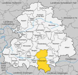
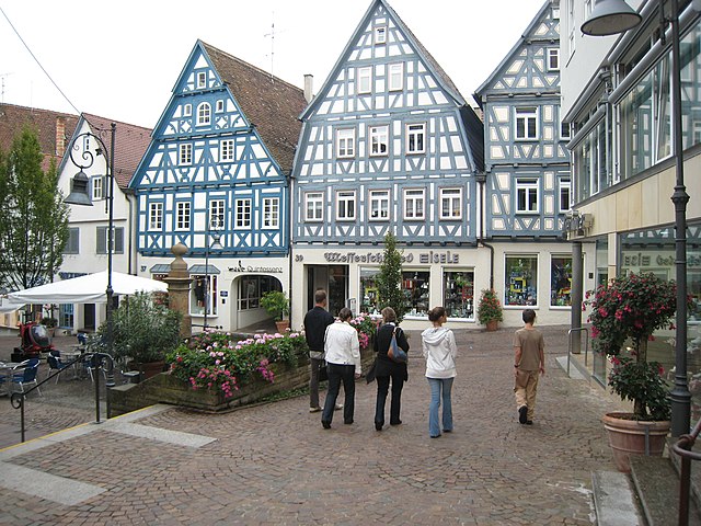
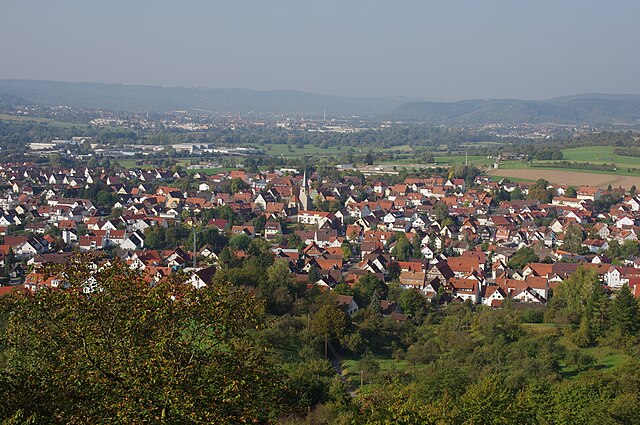
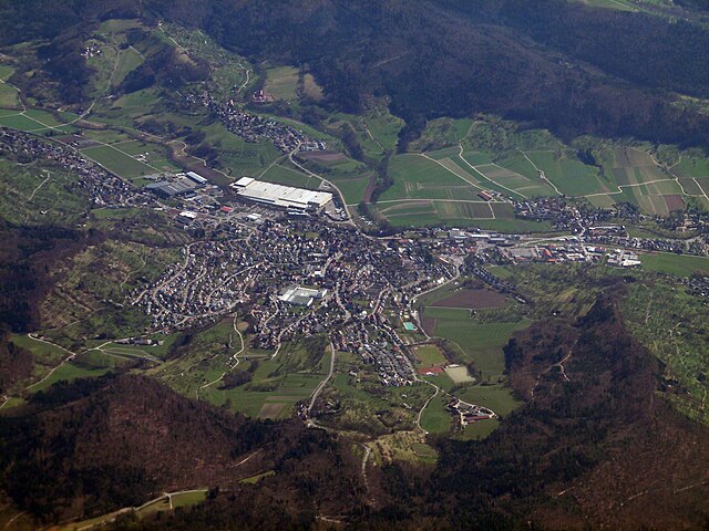
Schorndorf
- town in Baden-Württemberg, Germany
Hiking in Schorndorf
Schorndorf, located in the Baden-Württemberg region of Germany, is surrounded by beautiful landscapes that provide numerous hiking opportunities. The area is characterized by its rolling hills, lush forests, and scenic vineyards, making it an ideal destination for both novice and experienced hikers....
- Country:
- Postal Code: 73614
- Local Dialing Code: 07181
- Coordinates: 48° 48' 0" N, 9° 32' 0" E
- GPS tracks (wikiloc): [Link]
- AboveSeaLevel: 256 м m
- Area: 56.84 sq km
- Population: 38178
- Web site: [Link]


Backnang
- town in Baden-Württemberg, Germany
Hiking in Backnang
Backnang is a picturesque town located in the state of Baden-Württemberg, Germany, surrounded by beautiful nature and ideal for hiking enthusiasts. Here’s what you can expect when hiking in and around Backnang:...
- Country:
- Postal Code: 71522
- Local Dialing Code: 07191
- Coordinates: 48° 56' 47" N, 9° 25' 50" E
- GPS tracks (wikiloc): [Link]
- AboveSeaLevel: 271 м m
- Area: 39.4 sq km
- Population: 35368
- Web site: [Link]

Waiblingen
- town in Baden-Württemberg, Germany
Hiking in Waiblingen
Waiblingen, located in the state of Baden-Württemberg, Germany, offers scenic hiking opportunities that showcase the beauty of the surrounding landscapes. This area is characterized by a mix of nature trails, vineyards, and picturesque views along the Rems River....
- Country:
- Postal Code: 71336; 71334; 71332
- Local Dialing Code: 07146; 07151
- Licence Plate Code: WN
- Coordinates: 48° 49' 49" N, 9° 19' 1" E
- GPS tracks (wikiloc): [Link]
- AboveSeaLevel: 230 м m
- Area: 42.76 sq km
- Population: 53407
- Web site: [Link]


Fellbach
- city in Germany
Hiking in Fellbach
Fellbach, located in the state of Baden-Württemberg, Germany, offers various hiking options that cater to different skill levels and preferences. Here are some key points about hiking in the area:...
- Country:
- Postal Code: 70736; 70734
- Local Dialing Code: 0711
- Licence Plate Code: WN
- Coordinates: 48° 48' 31" N, 9° 16' 33" E
- GPS tracks (wikiloc): [Link]
- AboveSeaLevel: 287 м m
- Area: 27.7 sq km
- Population: 45147
- Web site: [Link]


Burgstetten
- municipality in Germany
Hiking in Burgstetten
Burgstetten is a small municipality located in the Rems-Murr-Kreis district in Baden-Württemberg, Germany. This area offers beautiful natural landscapes, making it a great destination for hiking enthusiasts....
- Country:
- Postal Code: 71576
- Local Dialing Code: 07191
- Licence Plate Code: WN
- Coordinates: 48° 55' 41" N, 9° 22' 21" E
- GPS tracks (wikiloc): [Link]
- AboveSeaLevel: 255 м m
- Area: 10.29 sq km
- Population: 3572
- Web site: [Link]


Althütte
- municipality in Germany
Hiking in Althütte
Althütte, located in the beautiful region of Baden-Württemberg, Germany, offers a variety of hiking trails suitable for different skill levels, from leisurely walks to more challenging hikes. The area is known for its picturesque landscapes, including lush forests, rolling hills, and scenic views....
- Country:
- Postal Code: 71566
- Local Dialing Code: 07183
- Licence Plate Code: WN
- Coordinates: 48° 54' 47" N, 9° 34' 19" E
- GPS tracks (wikiloc): [Link]
- AboveSeaLevel: 497 м m
- Area: 18.15 sq km
- Population: 4041
- Web site: [Link]


Großerlach
- municipality in Germany
Hiking in Großerlach
Großerlach, located in the state of Baden-Württemberg, Germany, is a picturesque area ideal for hiking enthusiasts. The landscape features a mix of rolling hills, dense forests, and serene meadows, making it a great destination for outdoor activities....
- Country:
- Postal Code: 71560; 71577
- Local Dialing Code: 07903
- Licence Plate Code: WN
- Coordinates: 49° 3' 12" N, 9° 30' 52" E
- GPS tracks (wikiloc): [Link]
- AboveSeaLevel: 522 м m
- Area: 27.14 sq km
- Population: 2446
- Web site: [Link]


Kaisersbach
- municipality in Germany
Hiking in Kaisersbach
Kaisersbach, located in Baden-Württemberg, Germany, is a beautiful area for hiking enthusiasts. Nestled in the Schwäbisch Hall district, it offers a variety of scenic trails that cater to different skill levels. Here are some highlights of hiking in Kaisersbach:...
- Country:
- Postal Code: 73667
- Local Dialing Code: 07184
- Licence Plate Code: WN
- Coordinates: 48° 55' 49" N, 9° 38' 20" E
- GPS tracks (wikiloc): [Link]
- AboveSeaLevel: 569 м m
- Area: 27.94 sq km
- Population: 2487
- Web site: [Link]


Kirchberg an der Murr
- municipality in Germany
Hiking in Kirchberg an der Murr
Kirchberg an der Murr is a picturesque village located in the Baden-Württemberg region of Germany. It's surrounded by beautiful landscapes, making it an excellent destination for hiking enthusiasts. Here are some highlights and tips for hiking in this area:...
- Country:
- Postal Code: 71736–71737
- Local Dialing Code: 07144
- Licence Plate Code: WN
- Coordinates: 48° 56' 35" N, 9° 20' 27" E
- GPS tracks (wikiloc): [Link]
- AboveSeaLevel: 284 м m
- Area: 13.22 sq km
- Population: 3715
- Web site: [Link]

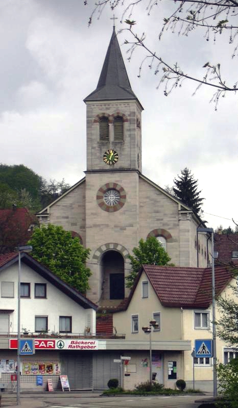
Urbach
- municipality in Baden-Württemberg, Germany
Hiking in Urbach
Urbach, located in Baden-Württemberg, Germany, is surrounded by scenic landscapes and offers a variety of hiking opportunities. The region is characterized by rolling hills, forests, and picturesque views, which make it an attractive destination for both casual walkers and avid hikers. Here are some key points about hiking in Urbach:...
- Country:
- Postal Code: 73656–73660
- Local Dialing Code: 07181
- Licence Plate Code: WN
- Coordinates: 48° 48' 48" N, 9° 34' 44" E
- GPS tracks (wikiloc): [Link]
- AboveSeaLevel: 275 м m
- Area: 20.76 sq km
- Population: 8744
- Web site: [Link]

Rudersberg
- municipality in Germany
Hiking in Rudersberg
Rudersberg, located in the Rems-Murr district of Baden-Württemberg, Germany, offers a variety of hiking opportunities in a picturesque landscape characterized by rolling hills, forests, and charming villages. The area is part of the Swabian Jura, which features many well-marked trails and scenic viewpoints....
- Country:
- Postal Code: 73635
- Local Dialing Code: 07183
- Licence Plate Code: WN
- Coordinates: 48° 53' 7" N, 9° 31' 45" E
- GPS tracks (wikiloc): [Link]
- AboveSeaLevel: 280 м m
- Area: 39.37 sq km
- Population: 11113
- Web site: [Link]

Kernen im Remstal
- municipality in Germany
Hiking in Kernen im Remstal
Kernen is a lovely destination for hiking, surrounded by beautiful landscapes and a variety of trails suitable for different skill levels. Located near the Swabian Jura in Germany, it offers scenic views, wooded areas, and gentle hills, making it ideal for both casual walkers and more experienced hikers....
- Country:
- Postal Code: 71394
- Local Dialing Code: 07151
- Licence Plate Code: WN; BK
- Coordinates: 48° 47' 20" N, 9° 20' 29" E
- GPS tracks (wikiloc): [Link]
- AboveSeaLevel: 291 м m
- Area: 15.05 sq km
- Population: 15041
- Web site: [Link]

Spiegelberg
- municipality in Germany
Hiking in Spiegelberg
Spiegelberg is a charming area located in the state of Baden-Württemberg, Germany, known for its scenic landscapes and outdoor recreational opportunities. Hiking in Spiegelberg offers a variety of trails suitable for different skill levels, from easy walks to more challenging hikes....
- Country:
- Postal Code: 71579
- Local Dialing Code: 07194
- Licence Plate Code: WN
- Coordinates: 49° 2' 15" N, 9° 26' 45" E
- GPS tracks (wikiloc): [Link]
- AboveSeaLevel: 383 м m
- Area: 28.22 sq km
- Population: 2136
- Web site: [Link]
Leutenbach
- municipality in Germany
Hiking in Leutenbach
Leutenbach, located in Baden-Württemberg, Germany, offers various hiking opportunities for outdoor enthusiasts. The area is characterized by picturesque landscapes, rolling hills, lush forests, and tranquil rural settings....
- Country:
- Postal Code: 71397
- Local Dialing Code: 07195
- Licence Plate Code: WN
- Coordinates: 48° 53' 18" N, 9° 23' 29" E
- GPS tracks (wikiloc): [Link]
- AboveSeaLevel: 277 м m
- Area: 14.73 sq km
- Population: 11095
- Web site: [Link]


Schwaikheim
- municipality in Germany
Hiking in Schwaikheim
Schwaikheim is a small town located in the state of Baden-Württemberg, Germany, not too far from cities like Stuttgart. While it may not be the most famous hiking destination, it does offer some pleasant outdoor experiences and nature trails for hiking enthusiasts....
- Country:
- Postal Code: 71409
- Local Dialing Code: 07195
- Licence Plate Code: WN
- Coordinates: 48° 52' 38" N, 9° 20' 58" E
- GPS tracks (wikiloc): [Link]
- AboveSeaLevel: 267 м m
- Area: 9.22 sq km
- Population: 9465
- Web site: [Link]


Aspach
- municipality in Germany
Hiking in Aspach
Aspach, located in Baden-Württemberg, Germany, offers several wonderful hiking opportunities. Known for its picturesque landscapes, rolling hills, and lush forests, hiking in this region allows you to experience the beauty of the Swabian region....
- Country:
- Postal Code: 71546
- Local Dialing Code: 07191; 07148
- Licence Plate Code: WN
- Coordinates: 48° 58' 0" N, 9° 23' 51" E
- GPS tracks (wikiloc): [Link]
- AboveSeaLevel: 295 м m
- Area: 35.46 sq km
- Population: 7950
- Web site: [Link]


Allmersbach
- municipality in Germany
Hiking in Allmersbach
Allmersbach is a charming locality located in the district of Rems-Murr-Kreis in Baden-Württemberg, Germany. It offers a range of scenic hiking opportunities that cater to both beginners and experienced hikers. Here are some highlights about hiking in and around Allmersbach:...
- Country:
- Postal Code: 71573
- Local Dialing Code: 07191
- Licence Plate Code: WN
- Coordinates: 48° 54' 24" N, 9° 28' 5" E
- GPS tracks (wikiloc): [Link]
- AboveSeaLevel: 287 м m
- Area: 7.95 sq km
- Population: 4792
- Web site: [Link]


Murrhardt
- municipality in Germany
Hiking in Murrhardt
Murrhardt is a lovely town located in the Baden-Württemberg region of Germany, surrounded by picturesque nature that is perfect for hiking enthusiasts. Here are some key points about hiking in and around Murrhardt:...
- Country:
- Postal Code: 71540
- Local Dialing Code: 07192
- Coordinates: 48° 58' 46" N, 9° 34' 42" E
- GPS tracks (wikiloc): [Link]
- AboveSeaLevel: 291 м m
- Area: 71.13 sq km
- Population: 14006
- Web site: [Link]


Alfdorf
- municipality in Germany
Hiking in Alfdorf
Alfdorf, located in the Swabian Jura region of Germany, offers a variety of hiking opportunities for outdoor enthusiasts. The area is characterized by its picturesque landscapes, rolling hills, lush forests, and scenic views. Here are some highlights of hiking in and around Alfdorf:...
- Country:
- Postal Code: 73655; 73553
- Local Dialing Code: 07172
- Licence Plate Code: WN
- Coordinates: 48° 50' 43" N, 9° 43' 8" E
- GPS tracks (wikiloc): [Link]
- AboveSeaLevel: 487 м m
- Area: 68.52 sq km
- Population: 7053
- Web site: [Link]


Welzheim
- municipality in Germany
Hiking in Welzheim
Welzheim, located in the beautiful Swabian region of Germany, is a fantastic destination for hiking enthusiasts. Surrounded by the lush landscapes of the Swabian Forest, the area offers a variety of trails and stunning natural scenery. Here are some highlights and tips for hiking in Welzheim:...
- Country:
- Postal Code: 73642
- Local Dialing Code: 07182
- Licence Plate Code: WN
- Coordinates: 48° 52' 29" N, 9° 38' 4" E
- GPS tracks (wikiloc): [Link]
- AboveSeaLevel: 503 м m
- Area: 37.99 sq km
- Population: 11133
- Web site: [Link]


Winnenden
- municipality in Germany
Hiking in Winnenden
Winnenden, located in the state of Baden-Württemberg, Germany, offers a variety of picturesque hiking opportunities that cater to different skill levels. The surrounding landscape is characterized by rolling hills, forests, and vineyards, making it a beautiful area for outdoor activities....
- Country:
- Postal Code: 71349–71364
- Local Dialing Code: 07195
- Licence Plate Code: WN
- Coordinates: 48° 52' 35" N, 9° 23' 52" E
- GPS tracks (wikiloc): [Link]
- AboveSeaLevel: 292 м m
- Area: 28.05 sq km
- Population: 27932
- Web site: [Link]


Winterbach
- municipality in Baden-Württemberg, Germany
Hiking in Winterbach
Winterbach, located in Baden-Württemberg, Germany, is a charming area that offers beautiful natural landscapes ideal for hiking. Here’s a guide to hiking in Winterbach:...
- Country:
- Postal Code: 73650
- Local Dialing Code: 07181
- Licence Plate Code: WN
- Coordinates: 48° 47' 57" N, 9° 28' 48" E
- GPS tracks (wikiloc): [Link]
- AboveSeaLevel: 258 м m
- Area: 17.13 sq km
- Population: 7532
- Web site: [Link]


Weinstadt
- city in Baden-Württemberg, Germany
Hiking in Weinstadt
Weinstadt, located in the Baden-Württemberg region of Germany, is known for its beautiful landscapes and extensive vineyards, making it a fantastic location for hiking enthusiasts. Here are some key points about hiking in Weinstadt:...
- Country:
- Postal Code: 71365–71384
- Local Dialing Code: 07151
- Licence Plate Code: WN
- Coordinates: 48° 48' 40" N, 9° 21' 56" E
- GPS tracks (wikiloc): [Link]
- AboveSeaLevel: 241 м m
- Area: 31.71 sq km
- Population: 26685
- Web site: [Link]


Sulzbach an der Murr
- municipality in Germany
Hiking in Sulzbach an der Murr
Sulzbach an der Murr is a lovely town in the Baden-Württemberg region of Germany, surrounded by picturesque landscapes that make it an appealing location for hiking enthusiasts. The area boasts a mix of natural beauty, rich cultural history, and well-marked trails suitable for various skill levels....
- Country:
- Postal Code: 71560
- Local Dialing Code: 07193
- Licence Plate Code: WN
- Coordinates: 49° 0' 11" N, 9° 30' 1" E
- GPS tracks (wikiloc): [Link]
- AboveSeaLevel: 273 м m
- Area: 40.11 sq km
- Population: 5285
- Web site: [Link]

Remshalden
- municipality in Germany
Hiking in Remshalden
Remshalden, located in the Baden-Württemberg region of Germany, is a delightful destination for hiking enthusiasts. The area is set against a backdrop of beautiful landscapes, including the scenic hills and valleys of the Rems River Valley. Here are some highlights and tips for hiking in Remshalden:...
- Country:
- Postal Code: 73625–73630
- Local Dialing Code: 07181; 07151
- Licence Plate Code: WN
- Coordinates: 48° 48' 52" N, 9° 25' 15" E
- GPS tracks (wikiloc): [Link]
- AboveSeaLevel: 271 м m
- Area: 15.15 sq km
- Population: 13630
- Web site: [Link]


Auenwald
- municipality in Germany
Hiking in Auenwald
Auenwald, also known as riparian forest or floodplain forest, is typically characterized by its unique ecosystems along rivers and wetlands. While it may not be a specific, well-known hiking destination like national parks or mountain ranges, hiking in areas with Auenwald can offer a beautiful blend of nature, biodiversity, and peaceful surroundings....
- Country:
- Postal Code: 71549
- Local Dialing Code: 07191
- Licence Plate Code: WN
- Coordinates: 48° 56' 13" N, 9° 30' 3" E
- GPS tracks (wikiloc): [Link]
- AboveSeaLevel: 280 м m
- Area: 19.76 sq km
- Population: 6767
- Web site: [Link]
Berglen
- municipality in Germany
Hiking in Berglen
Berglen, located in the German state of Baden-Württemberg, is known for its beautiful landscapes and hiking opportunities. The region is characterized by rolling hills, forests, and scenic views, making it a great destination for outdoor enthusiasts. Here’s what you can expect when hiking in Berglen:...
- Country:
- Postal Code: 73663
- Local Dialing Code: 07183; 07181; 07195
- Licence Plate Code: WN
- Coordinates: 48° 51' 41" N, 9° 28' 10" E
- GPS tracks (wikiloc): [Link]
- AboveSeaLevel: 309 м m
- Area: 25.87 sq km
- Population: 6317
- Web site: [Link]

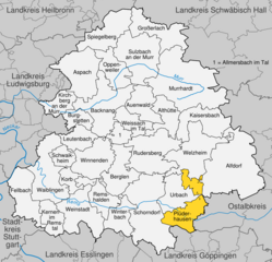
Plüderhausen
- municipality in Germany
Hiking in Plüderhausen
Plüderhausen, located in the Rems-Murr-Kreis district of Baden-Württemberg, Germany, offers various hiking opportunities characterized by scenic landscapes, lush greenery, and a blend of nature and culture. Here are some highlights for hiking in the area:...
- Country:
- Postal Code: 73655
- Local Dialing Code: 07181
- Licence Plate Code: WN
- Coordinates: 48° 47' 42" N, 9° 36' 4" E
- GPS tracks (wikiloc): [Link]
- AboveSeaLevel: 274 м m
- Area: 26.13 sq km
- Population: 9252
- Web site: [Link]

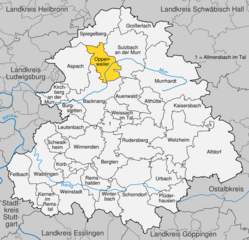
Oppenweiler
- municipality in Germany
Hiking in Oppenweiler
Oppenweiler is a quaint village located in Baden-Württemberg, Germany, which is surrounded by beautiful countryside and offers some lovely hiking opportunities. While the area may not be as well-known as larger hiking destinations, it provides a charming experience for those looking to explore nature in a serene setting....
- Country:
- Postal Code: 71570
- Local Dialing Code: 07191
- Coordinates: 48° 58' 58" N, 9° 27' 31" E
- GPS tracks (wikiloc): [Link]
- AboveSeaLevel: 264 м m
- Area: 19.81 sq km
- Population: 4103
- Web site: [Link]


Korb
- municipality in Germany
Hiking in Korb
Korb, located in the Baden-Württemberg region of Germany, offers a variety of hiking opportunities set against a backdrop of beautiful landscapes, vineyards, and forests. Here's an overview of hiking in and around Korb:...
- Country:
- Postal Code: 71404
- Local Dialing Code: 07151
- Licence Plate Code: WN
- Coordinates: 48° 50' 30" N, 9° 21' 40" E
- GPS tracks (wikiloc): [Link]
- AboveSeaLevel: 296 м m
- Area: 8.45 sq km
- Population: 10305
- Web site: [Link]

Weissach im Tal
- municipality in Germany
Hiking in Weissach im Tal
Weissach im Tal, located in the Rems-Murr-Kreis district of Baden-Württemberg, Germany, offers picturesque landscapes and a peaceful environment for hiking enthusiasts. The region is characterized by its rolling hills, lush forests, and beautiful meadows, making it an appealing destination for both casual walkers and experienced hikers....
- Country:
- Postal Code: 71554
- Local Dialing Code: 07191
- Licence Plate Code: WN
- Coordinates: 48° 55' 46" N, 9° 28' 43" E
- GPS tracks (wikiloc): [Link]
- AboveSeaLevel: 265 м m
- Area: 14.13 sq km
- Population: 7259
- Web site: [Link]
Shares border with regions:

Stuttgart
- capital city of German federated state Baden-Württemberg
Hiking in Stuttgart
Hiking in Stuttgart offers a fantastic blend of urban and natural experiences. The city is surrounded by beautiful landscapes, vineyards, and wooded hills, making it an excellent base for outdoor enthusiasts. Here are some highlights and popular hiking areas around Stuttgart:...
- Country:
- Postal Code: 70619; 70599; 70597; 70569; 70567; 70565; 70563; 70499; 70469; 70376; 70439; 70437; 70435; 70378; 70374; 70372; 70329; 70327; 70199; 70197; 70195; 70193; 70192; 70191; 70190; 70188; 70186; 70184; 70182; 70180; 70178; 70176; 70174; 70173
- Local Dialing Code: 711
- Licence Plate Code: S
- Coordinates: 48° 46' 34" N, 9° 10' 39" E
- GPS tracks (wikiloc): [Link]
- AboveSeaLevel: 247 м m
- Area: 207.33 sq km
- Population: 632743
- Web site: [Link]


Ludwigsburg
- district in Baden-Württemberg, Germany
Hiking in Ludwigsburg
Ludwigsburg is a district located in the state of Baden-Württemberg, Germany, and is known for its picturesque landscapes and rich cultural heritage. While the area itself may not be as prominent as some of the larger mountain ranges in Germany, it offers several beautiful hiking opportunities that cater to different skill levels....
- Country:
- Capital: Ludwigsburg
- Licence Plate Code: LB
- Coordinates: 48° 54' 0" N, 9° 12' 0" E
- GPS tracks (wikiloc): [Link]
- AboveSeaLevel: 266 м m
- Area: 686.83 sq km
- Population: 534074
- Web site: [Link]