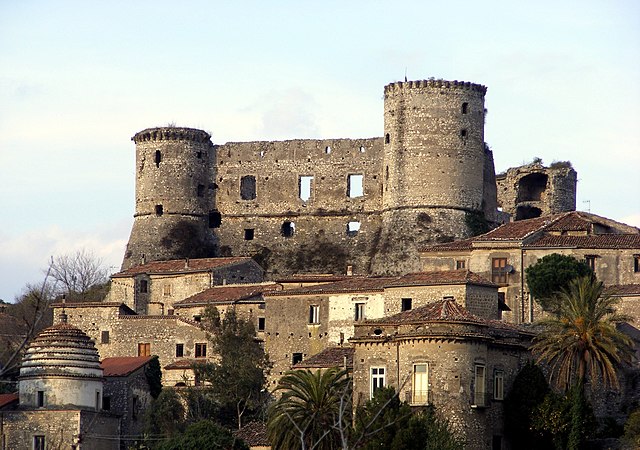
Riardo (Riardo)
.svg)
- Italian comune
 Hiking in Riardo
Riardo is a charming town in the Campania region of Italy, nestled in an area that offers some beautiful hiking opportunities. While it might not be as well-known as some of the larger national parks in Italy, Riardo's surroundings provide a mix of scenic landscapes, historical sites, and local culture that can enhance your hiking experience. Here are a few key points to consider for hiking in and around Riardo:
1.
- The area around Riardo features various trails that lead through lush greenery, rolling hills, and picturesque countryside. The terrain can vary from easy walks to more challenging hikes, making it suitable for hikers of all skill levels.
2.
- The region boasts a rich natural environment, including diverse flora and fauna. Keep an eye out for local wildlife and enjoy the beauty of Mediterranean vegetation along the trails.
3.
- When hiking in Riardo, you may come across historical landmarks, such as old churches and ruins. These spots offer a glimpse into the local history and can make your hike more enriching.
4.
- Consider hiring a local guide who is familiar with the trails and can provide insight into the area's natural and cultural significance. They can also help with navigation and ensure a safe trekking experience.
5.
- The best time to hike in the area is typically from spring to early autumn when the weather is mild and enjoyable. Be sure to check the weather forecast before setting out to ensure safe hiking conditions.
6.
- Bring plenty of water, wear sturdy hiking boots, and dress in layers, as temperatures can vary throughout the day. A good map or GPS device can also be helpful in navigating the trails.
7.
- After your hike, indulge in local cuisine. The Campania region is famous for its delicious food, including fresh produce and local dishes, offering a delightful way to replenish your energy.
Hiking in Riardo can be a rewarding experience, combining nature, exercise, and cultural discovery. Just take the necessary precautions, respect nature, and enjoy the stunning landscapes that this beautiful area has to offer!
- Country:

- Postal Code: 81053
- Local Dialing Code: 0823
- Licence Plate Code: CE
- Coordinates: 41° 16' 0" N, 14° 9' 0" E


- GPS tracks (wikiloc): [Link]
- AboveSeaLevel: 192 м m
- Area: 16.48 sq km
- Population: 2319
- Web site: http://www.comune.riardo.ce.it
- Wikipedia en: wiki(en)
- Wikipedia: wiki(it)
- Wikidata storage: Wikidata: Q58807
- Wikipedia Commons Category: [Link]
- Freebase ID: [/m/0gm_9c]
- GeoNames ID: Alt: [6538726]
- VIAF ID: Alt: [236160149]
- OSM relation ID: [41186]
- GND ID: Alt: [7676530-1]
- UN/LOCODE: [ITRID]
- Trismegistos Geo ID: [32555]
- ISTAT ID: 061068
- Italian cadastre code: H268
Shares border with regions:
Pietramelara
- Italian comune
Hiking in Pietramelara
Pietramelara, located in the region of Campania in Italy, offers several hiking opportunities amidst its beautiful natural landscapes. The area is characterized by rolling hills, lush forests, and stunning views of the surrounding countryside. Here are some highlights and tips for hiking in Pietramelara:...
- Country:
- Postal Code: 81051
- Local Dialing Code: 0823
- Licence Plate Code: CE
- Coordinates: 41° 16' 0" N, 14° 11' 0" E
- GPS tracks (wikiloc): [Link]
- AboveSeaLevel: 132 м m
- Area: 23.93 sq km
- Population: 4692
- Web site: [Link]
Pietravairano
- Italian comune
Hiking in Pietravairano
Pietravairano is a charming town located in the province of Caserta, in the Campania region of Italy. Surrounded by the beautiful Apennine mountains, it offers several hiking opportunities for outdoor enthusiasts. Here’s what you need to know about hiking in and around Pietravairano:...
- Country:
- Postal Code: 81050
- Local Dialing Code: 0823
- Licence Plate Code: CE
- Coordinates: 41° 20' 0" N, 14° 10' 0" E
- GPS tracks (wikiloc): [Link]
- AboveSeaLevel: 258 м m
- Area: 33.49 sq km
- Population: 2965
- Web site: [Link]

Rocchetta e Croce
- Italian comune
Hiking in Rocchetta e Croce
Rocchetta e Croce is a picturesque hiking destination located in the Apennine Mountains of Italy, particularly in the region of Abruzzo. Known for its stunning landscapes, diverse flora and fauna, and rich cultural history, it provides a variety of trails suitable for hikers of all levels....
- Country:
- Postal Code: 81050
- Local Dialing Code: 0823
- Licence Plate Code: CE
- Coordinates: 41° 14' 14" N, 14° 9' 28" E
- GPS tracks (wikiloc): [Link]
- AboveSeaLevel: 459 м m
- Area: 13.01 sq km
- Population: 446
- Web site: [Link]

Teano
- Italian comune
Hiking in Teano
Teano, located in the Campania region of Italy, is surrounded by beautiful landscapes that make it a great destination for hiking enthusiasts. The area is characterized by its rolling hills, lush greenery, and scenic views, offering a variety of trails suitable for different skill levels....
- Country:
- Postal Code: 81057
- Local Dialing Code: 0823
- Licence Plate Code: CE
- Coordinates: 41° 15' 0" N, 14° 4' 0" E
- GPS tracks (wikiloc): [Link]
- AboveSeaLevel: 196 м m
- Area: 89.43 sq km
- Population: 12303
- Web site: [Link]
Vairano Patenora
- Italian comune
Hiking in Vairano Patenora
Vairano Patenora, located in the province of Caserta in the Campania region of Italy, offers a rich experience for hiking enthusiasts. The area is known for its diverse landscapes, including rolling hills, lush forests, and scenic views of the surrounding countryside....
- Country:
- Postal Code: 81058
- Local Dialing Code: 0823
- Licence Plate Code: CE
- Coordinates: 41° 20' 0" N, 14° 8' 0" E
- GPS tracks (wikiloc): [Link]
- AboveSeaLevel: 168 м m
- Area: 43.52 sq km
- Population: 6515
- Web site: [Link]